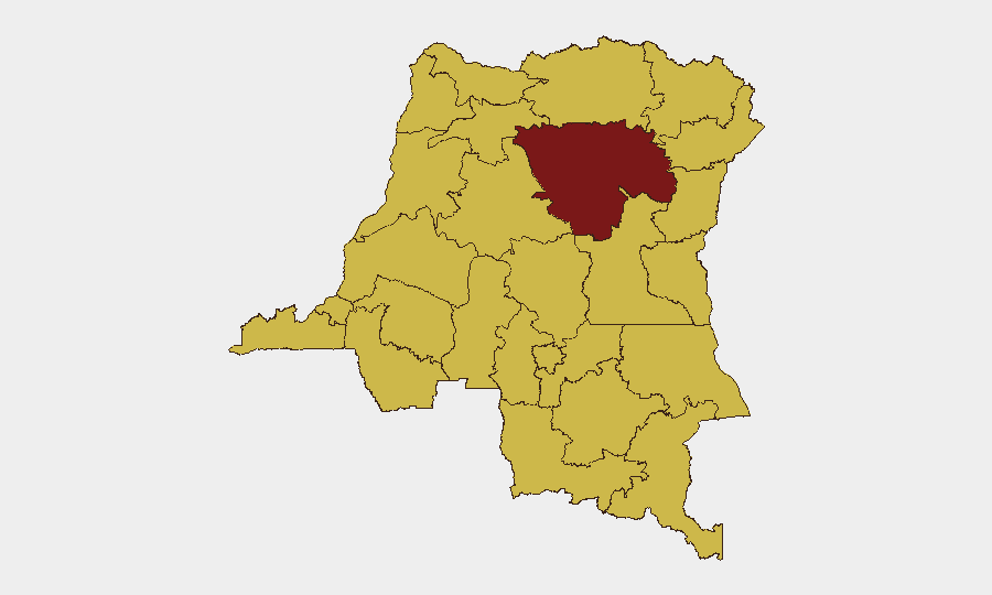
Situation Summary
DR Congo remains classified at global threat rank #13 (composite score 97), driven primarily by active armed conflict in the eastern provinces and sustained political tension in Kinshasa. The security environment is bifurcated: eastern conflict zones (Tshopo, North Kivu, South Kivu, Ituri) show ongoing heavy fighting between M23/AFC and FARDC-aligned forces with reported Rwandan involvement, while Kinshasa faces volatile protest mobilization around a contested constitutional referendum. Over the past 48 hours, the threat profile has remained acute with no material de-escalation in either theater.
Key Developments
- Kinshasa – heightened protest volatility (early–mid July, ongoing): Opposition coalition C64 maintains active mobilization in Gombe district and around Palais du Peuple despite postponement of nationwide protests from 8 July. Authorities warn of short-notice violence and elevated risk to N'Djili airport routes after dark; new mass protests are planned for 22 July.
- North Kivu – M23 troop reinforcements consolidating (reported through 10 July, persisting): M23 has deployed additional forces and weapons to villages along the RN2 corridor in southern Lubero (Kitsombiro, Alimbongo, Bingi) and eastern Walikale (Buleusa, Kateku), raising risks of road ambushes and civilian movement restrictions.
- South Kivu – fluid control changes and reprisal risk (early July, unresolved): M23-aligned Twirwaneho fighters and Wazalendo pro-government forces are contesting control of Kipupu and adjacent highlands with recent reported withdrawals and counterattacks; no stabilization evident in past 48 hours.
- North Kivu – sustained heavy fighting at Rubaya and Rutshuru (early July, active): Continued clashes between M23/AFC and FARDC units in key coltan mining areas have restricted humanitarian access and imposed road-movement constraints across Masisi–Rutshuru axes; drone use reported.
- South Kivu – ongoing Minembwe plateau clashes (early July, active): UN briefings confirm sustained intense fighting between AFC/M23 and FARDC/Wazalendo/FDLR-aligned forces for control of Minembwe and surrounding strategic terrain, with reported infrastructure damage and civilian-safety impacts.
- UN escalation warning (issued past several days, July 2026): UN Human Rights Commissioner has issued urgent calls for ceasefire, citing uptick in M23–FARDC clashes in South Kivu and grave human-rights violations; statement directly reflects current violence trajectory and calls for Rwandan troop withdrawal.
Highest-Risk Areas
Tshopo province carries the highest sub-national risk score (97.6) and is the primary driver of DR Congo's global ranking, reflecting the intensity and scale of eastern armed conflict. The next tier—Maniema, Sud-Ubangi, Équateur, Nord-Ubangi, Mongala, Lower Uele, Tshuapa, Upper Uele, Ituri, North Kivu, and Lualaba—all register 67.6, indicating widespread conflict and instability across the eastern and northern regions. This clustering reflects the geographic spread of M23/AFC operations, FARDC counter-operations, and localized militia activity; Kinshasa's political unrest, while acute, does not yet materially elevate the capital's sub-national ranking above these conflict zones.
How GeoBit Would Assist
Corporate security teams operating in DR Congo should employ AOI Monitoring & Early Warning on Kinshasa (Gombe, Palais du Peuple, N'Djili approaches) to track protest mobilization and obtain advance notice of road closures or curfews. Battle mapping and force-structure tracking in North and South Kivu (Minembwe, Rubaya, Rutshuru, Kipupu) provides real-time clarity on frontline positions and M23/FARDC disposition, enabling routing and network analysis to identify safe transit corridors and avoid ambush zones. OSINT fusion and multi-language search across conflict-monitoring feeds and local media yields early warning of control shifts and reprisal risks that may not appear in headline sources within 24–48 hours.
7-Day Outlook
Eastern conflict intensity is expected to remain high through mid-to-late July, with continued M23 consolidation and FARDC counter-operations creating fluid frontlines and humanitarian access constraints. In Kinshasa, political tension will likely spike in the week leading to the 22 July planned mass protests, increasing localized disruption and security incident risk. No major de-escalation is anticipated absent external diplomatic intervention or ceasefire enforcement.
Highest-Risk Areas — Ranked
| # | State / Region | Risk |
|---|---|---|
| 1 | Tshopo | 97.6 |
| 2 | Maniema | 67.6 |
| 3 | Sud-Ubangi | 67.6 |
| 4 | Équateur | 67.6 |
| 5 | Nord-Ubangi | 67.6 |
| 6 | Mongala | 67.6 |
| 7 | Lower Uele | 67.6 |
| 8 | Tshuapa | 67.6 |
| 9 | Upper Uele | 67.6 |
| 10 | Ituri | 67.6 |
| 11 | North Kivu | 67.6 |
| 12 | Lualaba | 67.6 |
Sources
Previous Daily Briefs
A new DR Congo brief is written every day — each with its own risk map and downloadable CSV. Here's the last week; use the calendar to go further back.
📅 Browse every day by calendar →
Highlighted days have a brief. Tap a day for that day's map & analysis, or “csv” for that day's dataset ($5).
Atlas — our AI intelligence desk — emails them this snapshot personally. Nothing else, no list.