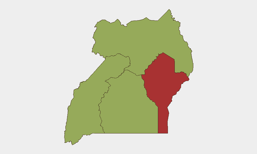
Situation Summary
Uganda remains a moderate-risk operating environment (#23 globally) characterized by concurrent political tension, aggressive law-enforcement operations, and residual health and border security hazards. Over the past 48 hours, the security picture has been defined by high-profile official statements defending recent detention campaigns, ongoing police operations in the north, and unconfirmed protest activity linked to parliamentary and activist concerns. The government's posture—signaled by President Museveni's July 28 defense of 1,711 arrests made between July 13–26—indicates sustained pressure on perceived dissent and criminality, creating operational friction in Kampala and secondary cities.
Key Developments
- Kampala CBD, Natete Cell (Nakasero 3 Ward) – 2026-07-20, statement released 2026-07-27/28: Uganda Police released clarification and video confirming armed officers discharged shots into the air around Kiseka Market at approximately 18:00 on July 20 while responding to a crowd obstructing an arrest operation. Two suspects were apprehended; traders reported prolonged disruption and civilian flight along Aga Khan Road and surrounding commercial arcades.
- Nationwide – 2026-07-28: President Museveni issued a public statement defending security operations conducted July 13–26, announcing 1,711 suspect detentions and calling for escalated action against "impunity," signaling continued aggressive policing and military deployment across regions.
- Northern Uganda, Madi Okolo District – operation 2026-07-25, reported 2026-07-27: Uganda Police confirmed a joint operation against illegal charcoal trade, resulting in large charcoal seizures and at least eight arrests as part of an enforcement response to a regional production and trade ban.
- Nationwide – 2026-07-25: Concurrent protest rallies against Parliament, activist arrests, and university public statements were recorded, flagged in security assessments as escalating political mobilization and government detention activity; specific casualty and location data remain preliminary.
- Uganda–South Sudan Border, Arua District – 2026-07-24 decision: Ugandan and South Sudanese authorities agreed following their 6th Joint Border Meeting to reactivate joint border security committees and re-mark the 470 km shared border by 2027, aiming to reduce banditry and improve migration management.
- Nationwide – Health Sector – 2026-07-25: Japan's International Federation of Red Cross provided a US$500,000 emergency grant to support Uganda's ongoing Ebola response, confirming the outbreak remains active and continues to affect travel and health risk assessments.
- Political – Ongoing Case: Human Rights Watch reiterated concerns about opposition politician Muwanga Kivumbi, detained by armed soldiers on July 10 near Kampala, with habeas corpus proceedings active—case cited as indicator of heightened political-repression perception.
Highest-Risk Areas
Eastern Uganda (risk 77.2) and Central Uganda (risk 57.9) drive the country's composite threat ranking, with Eastern Region significantly elevated due to ongoing armed group activity, cross-border dynamics, and banditry linked to the South Sudan frontier and broader regional instability. Central Region, encompassing Kampala and surrounding districts, faces elevated risk from political tension, law-enforcement friction with civilians, detention-related activism, and urban crime. Western and Northern Regions (50 and 49.3 respectively) remain secondary concern areas, though Northern Region's proximity to South Sudan and ongoing charcoal-trade operations warrant sustained attention.
How GeoBit Would Assist
Corporate security teams would deploy AOI Monitoring & Early Warning on Kampala CBD, Eastern Region border zones, and protest-activity hotspots to detect operational friction or escalation in real time. Network & Actor Analysis combined with Intel Sweep (X/Twitter, Telegram, YouTube OSINT) would track emerging political-mobilization narratives, detention announcements, and activist response, enabling predictive duty-of-care planning. GIS & Spatial Analysis integrated with conflict mapping would support alternative-routing planning for supply chains and personnel movement away from active police/military operations in Northern Uganda and high-friction urban zones.
7-Day Outlook
Near-term trajectory suggests continued official enforcement intensity, with further detention announcements and police operations likely in northern and central zones as the government sustains its "impunity" crackdown. Political mobilization is expected to persist or escalate, particularly around parliamentary activity and activist networks, generating localized friction points in Kampala. Health and border risks (Ebola, South Sudan frontier banditry) will remain stable but operationally relevant to corporate mobility and supply planning.
Highest-Risk Areas — Ranked
| # | State / Region | Risk |
|---|---|---|
| 1 | Eastern Region | 77.2 |
| 2 | Central Region | 57.9 |
| 3 | Western Region | 50 |
| 4 | Northern Region | 49.3 |
Sources
Previous Daily Briefs
A new Uganda brief is written every day — each with its own risk map and downloadable CSV. Here's the last week; use the calendar to go further back.
📅 Browse every day by calendar →
Highlighted days have a brief. Tap a day for that day's map & analysis, or “csv” for that day's dataset ($5).
Atlas — our AI intelligence desk — emails them this snapshot personally. Nothing else, no list.