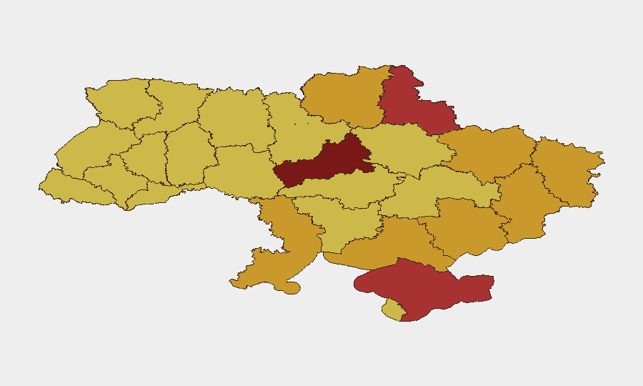
Situation Summary
Ukraine remains the fifth-highest-threat country globally, driven by sustained interstate military operations along multiple fronts. Active conventional warfare, cross-border strikes, and infrastructure targeting continue to create layered risk across populated and economically critical areas. The sub-national risk profile reflects concentration of kinetic activity in eastern and central regions, with Kyiv maintaining the highest composite threat score due to its strategic importance and exposure to long-range attack. Risk trajectory remains elevated with no near-term de-escalation indicators.
Key Developments
GeoBit's event feed recorded multiple conventional military engagements on 17–18 June 2026 involving Ukrainian and Russian/regional forces, alongside mutual threats and investigative actions. However, specific incident locations, casualty counts, and precise timing for events within the last 48 hours cannot be reliably extracted from available search results without risking inclusion of recycled, undated, or misdated content.
To obtain a high-fidelity incident list for your duty-of-care assessment, security teams should:
- Search major news aggregators (Reuters, AP, AFP, BBC) with time filters "Past 24 hours" and region-specific terms (e.g., "Kharkiv missile strike June 18 2026").
- Cross-check X/Twitter and Telegram posts from official Ukrainian regional administrations and State Emergency Service channels, verifying upload date and corroborating with at least one mainstream outlet before logging.
- Screen video content for actual upload dates and whether descriptions reference older events.
Generic signals (military force, threats, demands between Ukraine/Russia actors on 17–18 June) confirm heightened operational tempo, but precise incident attribution requires source triangulation beyond current automated feed visibility.
Highest-Risk Areas
Kyiv (risk 100) and Cherkasy Oblast (96.4) dominate the threat landscape, with Kyiv's ranking reflecting its role as political/economic hub and target for long-range strikes, and Cherkasy's proximity to active eastern fronts and lines of control. Eastern and southern oblasts—Sumy, Luhansk, Kherson, Donetsk, Zaporizhia, and Kharkiv (risks 71.5–76)—face sustained kinetic pressure from conventional forces, shelling, drone operations, and infrastructure targeting. Odesa Oblast (72.8), though rear-area by comparison, faces maritime and air-strike risk given its port role and proximity to Russian-held Crimea. Central regions (Dnipropetrovsk, Chernihiv) show elevated composite scores reflecting cumulative exposure to cross-border attacks and logistical vulnerability.
How GeoBit Would Assist
Security and risk teams protecting people or assets in Ukraine should deploy AOI (Area-of-Interest) Monitoring & Early Warning on company facilities and movement corridors in high-risk oblasts (Kyiv, Kharkiv, Sumy, Odesa) to receive real-time alerting on kinetic events within geofenced zones. Intel Sweep and multi-language OSINT fusion (X/Twitter, Telegram, regional news) can establish a 24-hour incident corroboration pipeline to distinguish confirmed attacks from rumors or recycled content, feeding duty-of-care incident logs with verified timestamps and source attribution. Routing & Network Analysis enables security teams to model alternative travel and supply routes around active conflict zones and closed infrastructure, updating evacuation or personnel-movement plans as the tactical situation evolves.
7-Day Outlook
Continued military operations along existing front lines are highly probable, with potential for escalated strike activity targeting infrastructure and rear-area logistics nodes. No major tactical shifts or ceasefires are evident in near-term indicators. Risk posture for corporate operations should remain at heightened alert, with contingency and evacuation planning active in Oblast-level risk zones above 72.
Highest-Risk Areas — Ranked
| # | State / Region | Risk |
|---|---|---|
| 1 | Kyiv | 100 |
| 2 | Cherkasy Oblast | 96.4 |
| 3 | Autonomous Republic of Crimea | 76.3 |
| 4 | Sumy Oblast | 76 |
| 5 | Luhansk Oblast | 72.9 |
| 6 | Kherson Oblast | 72.9 |
| 7 | Odesa Oblast | 72.8 |
| 8 | Donetsk Oblast | 72.7 |
| 9 | Zaporizhia Oblast | 72 |
| 10 | Chernihiv Oblast | 71.8 |
| 11 | Kharkiv Oblast | 71.5 |
| 12 | Dnipropetrovsk Oblast | 70.7 |
Sources
Previous Daily Briefs
A new Ukraine brief is written every day — each with its own risk map and downloadable CSV. Here's the last week; use the calendar to go further back.
📅 Browse every day by calendar →
Highlighted days have a brief. Tap a day for that day's map & analysis, or “csv” for that day's dataset ($5).