Situation Summary
Venezuela faces a compounded security crisis following twin earthquakes (magnitude 7.2 and 7.5) on June 24 that have killed at least 920–1,430 people and damaged critical infrastructure across the coastal corridor. Military-imposed access restrictions to affected zones, combined with severe shortages of water, food, fuel, and medical supplies, are driving civilian anger and increasing risks of resource-based civil unrest and confrontations at checkpoints. An active state of emergency overlaid on the existing "State of External Commotion" is enabling broad militarization of disaster zones and heightening the risk of arbitrary detention and heavy-handed crowd control. The security trajectory is deteriorating as humanitarian conditions worsen and public frustration with the official response deepens.
Key Developments
- Caracas & coastal states (June 27): Military cordons blocking civilian access to earthquake-devastated zones are generating confrontations at checkpoints as families search for missing relatives and volunteers attempt independent rescue efforts. Multiple social and news sources document mounting public anger over authorities impeding community-led aid.
- Simón Bolívar International Airport, Vargas state (June 26–27): The main international gateway serving Caracas remains closed indefinitely due to structural damage and loss of power and communications. Suspension of train service in Caracas further constrains movement in and out of the capital, complicating evacuations and aid delivery.
- Coastal earthquake zone (June 26–27): Continuing aftershocks along the affected coastal corridor pose ongoing risks to rescue operations, displaced populations, and already-compromised infrastructure, with seismological agencies warning of potential for additional damage.
- Earthquake-affected urban neighborhoods, coastal belt cities (June 26–27): Severe deficits in water, food, fuel, and medical supplies are driving residents to conduct informal rubble clearance and establish ad hoc distribution points. Humanitarian accounts document limited official presence and heightened short-term risks of crime and resource-competition violence.
- National emergency framework (June 26–27): Authorities have activated a nationwide state of emergency layered onto the pre-existing "State of External Commotion," substantially broadening executive power over security, economic, and political decisions and increasing the risk of arbitrary detention and disproportionate law-enforcement responses.
- Venezuela–Guyana border (June 26–27): Updated travel guidance reiterates that the territorial dispute zone remains volatile; tensions could escalate rapidly despite the domestic earthquake focus, creating a parallel conflict hotspot independent of disaster operations.
Highest-Risk Areas
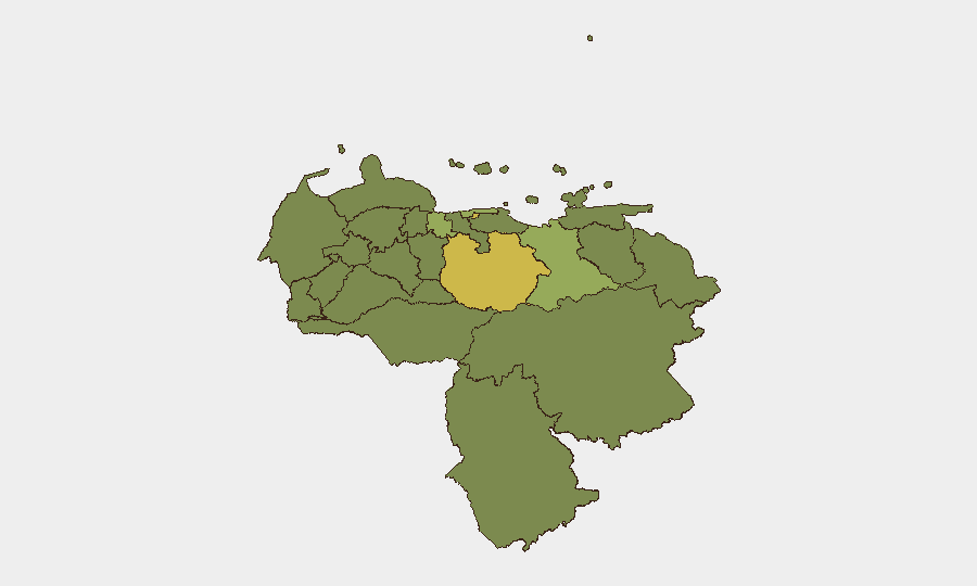
The Federal District (risk 66) and Guarico State (risk 62) are driving overall national risk, with the coastal belt states—Vargas (50.1), Anzoategui (47.2), and Carabobo (41.1)—presenting elevated threat from earthquake-related infrastructure collapse, resource scarcity, and civil unrest. Vargas, which hosts the closed international airport and major urban centers, faces compounded dangers from aftershock risk, militarized access control, and potential humanitarian crisis escalation. The geographic concentration of high-risk states in the northern and central regions reflects both seismic damage and the political concentration of enforcement activity in and around Caracas.
How GeoBit Would Assist
Security teams with people or assets in Venezuela should deploy AOI Monitoring & Early Warning to track checkpoint activity, protest movements, and resource-distribution flashpoints in real time across the Federal District, Vargas, and Anzoategui states. OSINT fusion and sentiment analysis (X/Twitter, Telegram, YouTube) can provide early detection of escalating civil anger, unauthorized rescue operations, or confrontations before they require response. Routing & Network Analysis enables identification of alternative movement corridors and safe passages around militarized zones and damaged infrastructure for personnel evacuation or resupply.
7-Day Outlook
Conditions in quake-affected zones are likely to deteriorate over the next week as supply shortages deepen and body-recovery operations continue, increasing the probability of larger civilian assemblies at military checkpoints and a heightened law-enforcement response. The risk of secondary incidents—looting, informal armed groups exploiting chaos, or politically motivated detention—will remain elevated throughout the emergency period. International evacuation demand will surge if airport reopening is further delayed or if humanitarian conditions in Caracas deteriorate markedly.
Highest-Risk Areas — Ranked
| # | State / Region | Risk |
|---|---|---|
| 1 | Federal District | 66 |
| 2 | Guarico State | 62 |
| 3 | Vargas State | 50.1 |
| 4 | Anzoategui State | 47.2 |
| 5 | Carabobo State | 41.1 |
| 6 | Amazonas State | 37.7 |
| 7 | Lara State | 36.9 |
| 8 | Miranda State | 36.7 |
| 9 | Aragua State | 36.6 |
| 10 | Barinas State | 36.4 |
| 11 | Tachira State | 36.3 |
| 12 | Merida State | 36.1 |
Sources
Previous Daily Briefs
A new Venezuela brief is written every day — each with its own risk map and downloadable CSV. Here's the last week; use the calendar to go further back.
📅 Browse every day by calendar →
Highlighted days have a brief. Tap a day for that day's map & analysis, or “csv” for that day's dataset ($5).