Situation Summary
Cyprus remains a low-threat environment with no major security incidents, civil unrest, or infrastructure disruptions reported in the last 24–48 hours. Recent activity centers on routine law-enforcement operations, a politically charged but contained anniversary protest at the Nicosia buffer-zone crossing, and minor inter-personal violence in Paphos. The security picture is stable, though heightened sensitivities around the 20 July anniversary and ongoing regional maritime exposure warrant continued monitoring of border areas and information-operations vectors.
Key Developments
- Nicosia, Metehan/Agios Dometios checkpoint – 20 July 2026
Greek Cypriot protesters gathered on the Republic side, chanting anti-Turkey slogans ahead of the 20 July anniversary. Security forces from both communities contained tensions without reported injuries; Turkey conducted an Air Force training flight in international airspace south of the island in response. No escalation observed.
- Republic of Cyprus, multiple locations – 19–20 July 2026
Police reported nine arrests during preventive operations targeting illegal stay, drug possession, vehicle theft, and illegal entry. Activity reflects routine but ongoing criminality; no organized crime or terrorism nexus indicated in reporting.
- Paphos district, rural field near Paphos town – 20 July 2026
Approximately ten young men of Syrian origin engaged in a fight with sticks; incident was localized and monitored by police. No wider civil unrest or communal escalation reported.
- Nicosia – 20 July 2026
An independent investigator alleged that a video produced by an Israeli private intelligence firm alleging Cypriot government corruption may constitute a hybrid attack on the state. No physical security impact; raises information-operations and reputational-risk concerns.
- Dubai/Cyprus – recent notification (within current week)
Cypriot authorities were informed of the arrest in Dubai of alleged organized-crime figure "Edik" on an international warrant. Nicosia is seeking clarification on warrant execution and implications for local investigation; no on-island security impact.
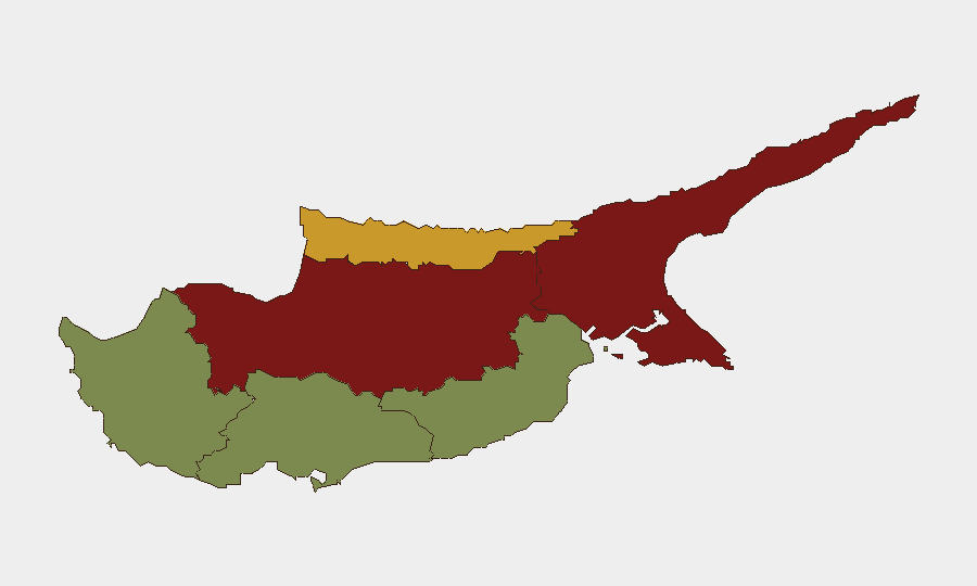
Highest-Risk Areas
Nicosia and Famagusta dominate the sub-national risk ranking (92 and 88 respectively), reflecting their status as divided cities straddling the buffer zone, exposure to symbolic anniversaries (20 July), cross-community tensions, and ongoing political investigations. Kyrenia (72) carries elevated risk tied to maritime exposure and historical sensitivities. By contrast, Larnaca, Limassol, and Paphos (28, 22, and 18) remain substantially lower-risk and are suitable for routine operations with standard duty-of-care measures.
How GeoBit Would Assist
Corporate security teams should deploy AOI Monitoring & Early Warning on Nicosia's checkpoint areas and Famagusta to track protest activity, cross-border movements, and security-force posture in real time. OSINT Fusion (X/Twitter, Telegram, local media) combined with Sentiment & Temporal Analysis enables early detection of anniversary-driven tension spikes or disinformation campaigns. Network & Actor Analysis supports financial-crime and organized-crime due diligence in relation to the Dubai arrest and its Cypriot connections, while Intel Sweep and multi-language search capture hybrid-attack vectors (video sting, media narratives) that may affect corporate reputation or governance risk.
7-Day Outlook
The 20 July anniversary window is entering its latter stages; contained protest activity and routine police operations suggest no imminent escalation. Regional sensitivities will persist through the week, particularly at crossing points and in media narratives. Barring unexpected political developments or cross-border incidents, Cyprus is expected to remain a stable, low-threat operating environment for corporate assets and personnel.
Highest-Risk Areas — Ranked
| # | State / Region | Risk |
|---|---|---|
| 1 | Nicosia | 92 |
| 2 | Famagusta | 88 |
| 3 | Kyrenia | 72 |
| 4 | Larnaca | 28 |
| 5 | Limassol | 22 |
| 6 | Paphos | 18 |
Sources
Previous Daily Briefs
A new Cyprus brief is written every day — each with its own risk map and downloadable CSV. Here's the last week; use the calendar to go further back.
📅 Browse every day by calendar →
Highlighted days have a brief. Tap a day for that day's map & analysis, or “csv” for that day's dataset ($5).
Atlas — our AI intelligence desk — emails them this snapshot personally. Nothing else, no list.