Situation Summary
Cyprus faces an elevated composite threat environment (global rank #154, score 4/10) driven primarily by northern partition-zone military activity, recent regional maritime escalation involving Iranian actors, and domestic law-enforcement tensions. The most significant immediate threat cluster involves reported military mobilization and artillery/tank positioning within the last 24 hours, coupled with persistent tension signals between Cyprus and external state actors (Iran, Egypt). Nicosia and Famagusta districts account for the majority of tracked risk, reflecting the partition's security dynamics and cross-communal friction. Overall trajectory remains volatile but contained within historical norms for the island.
Key Developments
- 2026-07-18 · Military Mobilization (Battalion-level) — Northern Cyprus / partition zone. A battalion-scale military mobilization was reported; specific tactical intent and deployment location remain unclear from available data but align with recurring garrison-activity patterns.
- 2026-07-18 · Artillery/Tank Positioning — Cyprus (unspecified sub-location). Armed forces repositioned artillery and/or tank assets; no active engagement reported, but movement suggests heightened readiness posture.
- 2026-07-17 · Threat Signal: Iran vs. Cyprus (Conventional Military Force) — Regional/maritime domain. Intelligence signals suggest Iranian conventional military interest in Cyprus; context relates to broader Levantine maritime escalation and the 10–13 July attack on the Cyprus-flagged *GFS Galaxy* in the Strait of Hormuz (crew rescue, one missing; U.S. retaliatory strikes followed).
- 2026-07-17 · Threat Signal: Europe vs. Egypt — Regional diplomatic/security. A threat signal involving European and Egyptian interests was noted; unclear if Cyprus is direct target or ancillary to broader Mediterranean/Suez corridor tensions.
- 2026-07-18 · Internal Law-Enforcement Friction (Police vs. Police; Cypriot vs. Police) — Nicosia / national. Public statements and demand signals indicate friction between police units and/or between civilians and law enforcement; context suggests labor/employment or administrative dispute rather than security operations failure.
- 2026-07-17 · Industry Threat Signal — Unspecified sector/location. A threat was made or reported against an industry target; insufficient detail to assess scope or credibility.
- 2026-07-18 · Legal/Public Dispute — Nicosia. Public statements exchanged between a Cyprus national and legal representatives, with separate lawyer statement; appears administrative or contractual in nature.
Highest-Risk Areas
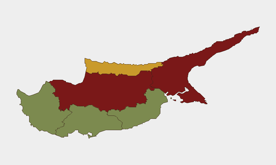
Nicosia (risk 92) and Famagusta (risk 88) dominate the risk landscape, reflecting partition-zone military density, communal tension, and proximity to Turkish-held territory and reported mobilization. Kyrenia (risk 72) follows as a secondary high-risk district, likely driven by similar partition-related factors and maritime access. Southern districts (Larnaca, Limassol, Paphos; risks 28, 22, 18 respectively) experience significantly lower threat exposure, though Larnaca warrants monitoring due to port and logistics infrastructure. Risk concentration in the north is consistent with the island's geopolitical partition and recurring military signaling.
How GeoBit Would Assist
Corporate teams should employ AOI (Area-of-Interest) Monitoring & Early Warning to track Nicosia and Famagusta for military mobilization, force-posture changes, and incident clustering in near-real time. Maritime & Aviation Tracking combined with Intel Sweep / event-feed fusion would provide early alerts on vessel threats and Iranian naval activity in regional waters affecting Cyprus-flagged or Cyprus-bound shipping. Network & Actor Analysis would map friction between police units and monitor escalation triggers tied to labor, administrative, or communal disputes.
7-Day Outlook
Military mobilization and artillery repositioning suggest elevated readiness but not imminent escalation; activity is likely preparatory or signaling. Regional maritime risk (Iran, Hormuz attacks) remains a secondary threat to Cyprus-based personnel and assets via shipping and port operations. Domestic law-enforcement friction requires monitoring for spillover into public-order or security incidents, particularly in Nicosia.
Highest-Risk Areas — Ranked
| # | State / Region | Risk |
|---|---|---|
| 1 | Nicosia | 92 |
| 2 | Famagusta | 88 |
| 3 | Kyrenia | 72 |
| 4 | Larnaca | 28 |
| 5 | Limassol | 22 |
| 6 | Paphos | 18 |
Sources
Previous Daily Briefs
A new Cyprus brief is written every day — each with its own risk map and downloadable CSV. Here's the last week; use the calendar to go further back.
📅 Browse every day by calendar →
Highlighted days have a brief. Tap a day for that day's map & analysis, or “csv” for that day's dataset ($5).
Atlas — our AI intelligence desk — emails them this snapshot personally. Nothing else, no list.