Situation Summary
Angola remains a moderate-risk environment (global rank #53) with composite threat score of 44, driven primarily by resource-extraction vulnerabilities, persistent insurgent activity in border provinces, and environmental hazards. The current 24-hour threat landscape is characterized by wildfire activity across multiple regions, which compounds logistics disruption and creates secondary humanitarian concerns. No major security incidents (armed clashes, mass protests, infrastructure attacks) have been verified in the last 24–48 hours; the threat picture remains consistent with established patterns in Cabinda, Lunda Norte/Sul, and Cuando Cubango provinces.
Key Developments
- Wildfire Activity (Multiple Locations, Ongoing) – At least 12 distinct wildfire events have been tracked across Angola in recent days (event IDs 1029075, 1029123, 1029100, 1029124, 1029082, 1029103, 1029126, 1029105, 1029104, 1029130, 1029134, 1028991). Specific locations and containment status require verification against regional fire-management authorities and local media; impact on transport corridors and mining operations should be monitored.
- No Verified Armed or Crime Incidents (Last 48h) – Web and open-source searches have not yielded independent confirmation of specific attacks, kidnappings, or major security breaches in the last 24–48 hours. Absence of reporting does not indicate safety; rather, communications and media coverage in remote/conflict-affected zones remain limited.
Highest-Risk Areas
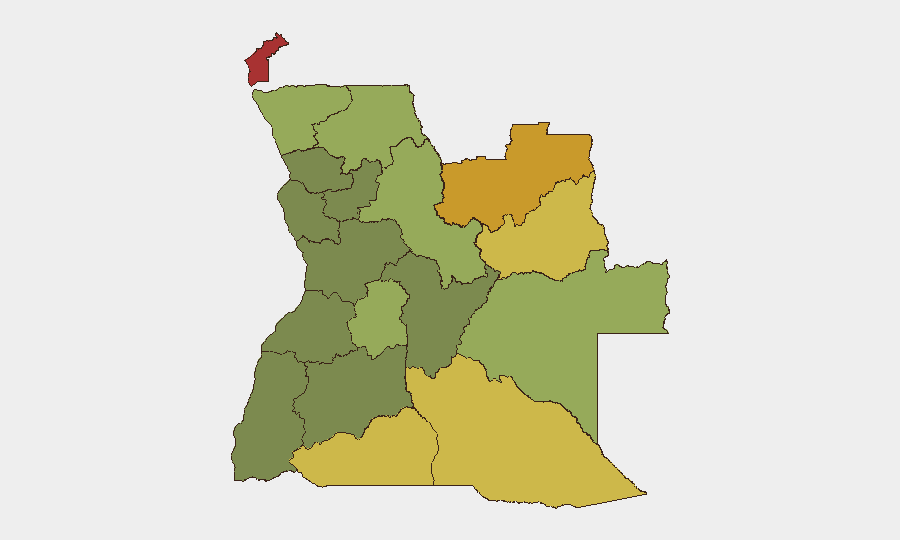
Cabinda Province (risk 78) and Lunda Norte Province (risk 72) remain the primary drivers of Angola's overall threat score, reflecting decades of resource-competition conflict, armed group presence, and weak state control in diamond and oil extraction zones. Lunda Sul (68), Cuando Cubango (64), and Cunene (62) extend this high-risk corridor across Angola's southeastern and southern borders, where cross-border criminal networks, displaced populations, and informal armed activity persist. By contrast, central provinces (Huambo, Uíge, Malanje) and southern regions (Bié, Huíla) present lower but still material risk; corporate and NGO operations in any of the top five provinces require heightened duty-of-care protocols, supply-chain redundancy, and real-time situational awareness.
How GeoBit Would Assist
Security teams should employ AOI (Area-of-Interest) Monitoring & Early Warning on Cabinda, Lunda Norte/Sul, and key transport/logistics corridors to detect armed activity, protest formation, or infrastructure threats in near-real time. Conflict & Military tracking and Network & Actor Analysis enable identification of active armed groups, force posture changes, and leadership movements that may signal escalation. Routing & Network Analysis can identify safe and alternate supply-chain pathways around high-risk provinces; Environmental & Health monitoring (including satellite and imagery analysis) tracks wildfire progression, infrastructure exposure, and secondary humanitarian risk that may trigger staffing or asset evacuation decisions.
7-Day Outlook
Wildfire activity is expected to persist given seasonal conditions; containment and air-quality impacts should be monitored daily against regional meteorological and fire-management updates. Armed group activity and resource-extraction competition in Cabinda and Lunda Norte remain at baseline elevated levels with no imminent flashpoint indicators detected, but the absence of 24-hour reporting should not be mistaken for stability. Personnel and asset security posture in the top five risk provinces should remain in heightened readiness, with supply-chain contingencies and evacuation routes pre-validated.
Highest-Risk Areas — Ranked
| # | State / Region | Risk |
|---|---|---|
| 1 | Cabinda Province | 78 |
| 2 | Lunda Norte Province | 72 |
| 3 | Lunda Sul Province | 68 |
| 4 | Cuando Cubango Province | 64 |
| 5 | Cunene Province | 62 |
| 6 | Moxico Province | 58 |
| 7 | Zaire Province | 54 |
| 8 | Huambo Province | 50 |
| 9 | Uíge Province | 48 |
| 10 | Malanje Province | 42 |
| 11 | Bié Province | 35 |
| 12 | Huíla Province | 32 |
Previous Daily Briefs
A new Angola brief is written every day — each with its own risk map and downloadable CSV. Here's the last week; use the calendar to go further back.
📅 Browse every day by calendar →
Highlighted days have a brief. Tap a day for that day's map & analysis, or “csv” for that day's dataset ($5).