Situation Summary
Barbados remains a low-threat environment with no validated acute security, crime, civil-unrest, or infrastructure incidents reported in the last 24–48 hours. The nation's composite threat score remains at 2 globally, placing it among the safer Caribbean jurisdictions for corporate operations and personnel. Crop Over festival activities in Bridgetown are proceeding without reported disruptions or public-safety events. The security posture is stable, with no indicators of deterioration in the near term.
Key Developments
- Bridgetown & festival zones (July 29, 2026): Crop Over security operations remain active with no reported crowd-control incidents, disruptions, or emergency deployments in the preceding 48 hours.
- Nationwide (July 28–29, 2026): Domestic news archives, police reporting, and social-media monitoring feeds confirm absence of new shootings, major crimes, or civil-unrest events within the last 24–48 hours.
- Regional emergency channels (July 28–29, 2026): Caribbean search-and-rescue and security networks report no Barbados-related emergency operations or deployments, and no spillover effects from regional activity affecting domestic security.
- Nationwide policy environment (late July 2026): Local media coverage reflects ongoing crime-prevention initiatives and community-engagement programs; no new acute incidents are triggering emergency or policy responses within the current 24–48 hour window.
Highest-Risk Areas
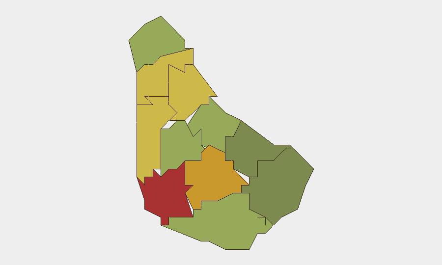
Saint Michael (risk 78) and Saint George (risk 72) drive the national risk profile, reflecting urban density, population concentration, and historical crime patterns in and around Bridgetown and its environs. Saint James (68) and Saint Andrew (65) maintain elevated scores consistent with multi-parish urban and semi-urban corridors. Collectively, the top five parishes account for the bulk of national risk despite the absence of recent acute events; risk ranking reflects structural vulnerability and baseline crime prevalence rather than current incident activity. Christ Church (42) and southern parishes show materially lower scores, suggesting lower operational risk for assets and personnel in those regions.
How GeoBit Would Assist
Corporate security teams with Barbados operations should employ AOI Monitoring & Early Warning on high-risk parishes (Saint Michael, Saint George) to detect emerging incidents or crowd dynamics in real time. Intel Sweep, global event feeds, and social-media OSINT (X/Twitter, Telegram, local news feeds) provide continuous 24/7 visibility of new threats, unrest, or criminal activity before they escalate. GIS & Spatial Analysis enables risk-based site selection and personnel routing away from highest-threat neighborhoods, while Routing & Network Analysis supports alternative journey planning during festival periods or localized incidents.
7-Day Outlook
No acute security deterioration is anticipated over the next seven days; festival operations are expected to conclude without major disruption. Baseline crime and social risk will remain the primary duty-of-care consideration for resident and mobile personnel. Continued monitoring of social media, police reporting, and festival-zone dynamics is warranted as standard practice, but no alert-level escalation is indicated.
Highest-Risk Areas — Ranked
| # | State / Region | Risk |
|---|---|---|
| 1 | Saint Michael | 78 |
| 2 | Saint George | 72 |
| 3 | Saint James | 68 |
| 4 | Saint Andrew | 65 |
| 5 | Saint Peter | 62 |
| 6 | Saint Joseph | 58 |
| 7 | Saint Thomas | 52 |
| 8 | Saint Lucy | 48 |
| 9 | Christ Church | 42 |
| 10 | Saint John | 35 |
| 11 | Saint Philip | 28 |
Sources
Previous Daily Briefs
A new Barbados brief is written every day — each with its own risk map and downloadable CSV. Here's the last week; use the calendar to go further back.
📅 Browse every day by calendar →
Highlighted days have a brief. Tap a day for that day's map & analysis, or “csv” for that day's dataset ($5).
Atlas — our AI intelligence desk — emails them this snapshot personally. Nothing else, no list.