Situation Summary
Belarus remains a transit zone and proxy staging area amid the Russia–Ukraine conflict, with elevated risks concentrated in border regions and the capital. Over the past 48 hours, a drone strike on a civilian bus near the Belarus–Russia border, discovery of a migrant tunnel under the Lithuania border, and military exercises near Ukraine have compounded an already strained security environment. Economic sanctions targeting key infrastructure and ongoing militarization of southern and eastern Belarus are driving corporate and duty-of-care exposure upward.
Key Developments
- Belarus–Russia border (Bryansk region), 29–30 July 2026: A drone strike on a civilian passenger bus carrying Belarusian citizens injured three people near the border. Belarus's Security Council secretary characterized the attack as "accidental" and publicly advised Belarusian nationals to avoid travel to Russia until the conflict ends, directly elevating cross-border ground-transport risk. Attribution remains contested (Russia blames Ukraine).
- Lazdijai district, Lithuania–Belarus border, 29–30 July 2026: Lithuanian border guards detected and partially excavated an unfinished 11-meter tunnel intended to facilitate irregular migration from Belarus into the EU near Pertakas village; approximately 20 foreign nationals fled back into Belarusian territory. The discovery underscores Belarus's role as a staging area for migration pressure and highlights sustained border-security volatility.
- Minsk, 30 July 2026: Belarusian meteorological authorities (Belhydromet) declared a red danger level for severe weather and infrastructure disruption, affecting transport and essential services in the capital region.
- Eastern Belarus (Krychaw–6 airfield), late July 2026 (reported 30–31 July): Opposition and monitoring sources report Russian Oreshnik ballistic missiles may be stationed at Krychaw–6, raising potential strike-launch and overflight risk in eastern Belarus.
- Belarus–Ukraine border districts, 29–30 July 2026: Belarusian territorial troops conducted military training exercises with concurrent tightened security measures, signaling continued militarization and potential travel restrictions in southern border areas.
- EU sanctions expansion, 23–30 July 2026: The EU's 21st sanctions package extended asset freezes to Mozyr Oil Refinery and European Trading Company LLC, introducing secondary economic and logistics disruption risk for fuel supply and industrial operations tied to these entities.
Highest-Risk Areas
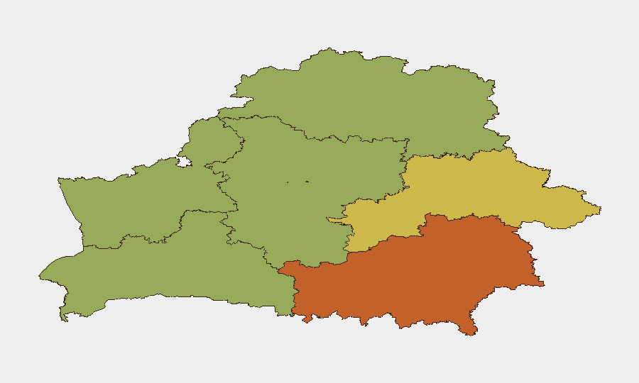
Homyel Region (risk 75) and Minsk (risk 68) dominate the sub-national ranking, with Homyel's proximity to the Russia–Ukraine conflict zone and Russian military staging areas driving acute exposure. Minsk itself faces dual pressure: capital-city infrastructure vulnerability (weather, services, security incidents) and concentration of diplomatic/commercial assets. Mahilyow Region (62) and Brest Region (55) follow, both bordering Ukraine and hosting military activity; Hrodna and Minsk Region remain elevated due to Lithuanian border exposure and irregular-migration corridors. Northern and western border districts carry sustained cross-border volatility.
How GeoBit Would Assist
Corporate teams operating in Belarus should employ AOI Monitoring & Early Warning to track Minsk, border crossings, and key infrastructure sites for real-time incident alerts. Routing & Network Analysis capabilities would support alternative travel planning away from cross-border routes and militarized zones. Conflict & Military tracking (force structure, weapons positioning) and OSINT fusion (Telegram, local incident reporting, opposition sources) enable early detection of escalation, exercise activity, and drone/strike risk before media saturation.
7-Day Outlook
Border volatility and drone-strike risk along the Russia–Belarus frontier are expected to persist through early August as regional conflict dynamics remain fluid. Weather disruptions in Minsk may compound service outages and transport delays. Travel advisories between Belarus and Russia will likely remain in effect; migration pressure and tunnel-digging activity suggest sustained irregular-crossing attempts along the Lithuania frontier.
Highest-Risk Areas — Ranked
| # | State / Region | Risk |
|---|---|---|
| 1 | Homyel Region | 75 |
| 2 | Minsk | 68 |
| 3 | Mahilyow Region | 62 |
| 4 | Brest Region | 55 |
| 5 | Hrodna Region | 52 |
| 6 | Minsk Region | 48 |
| 7 | Vitsebsk Region | 45 |
Sources
Previous Daily Briefs
A new Belarus brief is written every day — each with its own risk map and downloadable CSV. Here's the last week; use the calendar to go further back.
📅 Browse every day by calendar →
Highlighted days have a brief. Tap a day for that day's map & analysis, or “csv” for that day's dataset ($5).
Atlas — our AI intelligence desk — emails them this snapshot personally. Nothing else, no list.