Situation Summary
Belize remains a mid-tier crime-driven security concern (global rank #102, composite threat score 14), with gang and organized-crime violence concentrated in urban centers. Recent event signals from 2026-08-07 indicate ongoing street-level violence, including shootings with civilian casualties and fatalities in Belize City and Cayo District. The country's risk profile is heavily skewed toward its northern and central districts; however, no systemic escalation or organized conflict activity is currently assessed.
Key Developments
- Bullet Tree Road, Cayo District (2026-08-07): A shooting near the Puma gas station resulted in injuries to Carlton McKoy and a baby; McKoy reported in critical condition. Circumstances suggest targeted or opportunistic street violence.
- Swift Hall, Belize City (2026-08-07): A male fatality reported in an alleged robbery-related shooting. Police investigation ongoing; limited additional detail available.
- Belize River communities (2026-08-07): Department of the Environment issued an advisory following a mass fish kill affecting river communities and local trade. Origin and scope of environmental incident under investigation; potential secondary livelihood impact for downstream populations.
Highest-Risk Areas
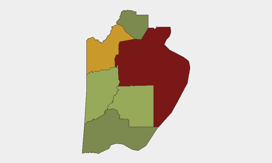
Belize District (risk score 95) and Orange Walk District (risk score 72) dominate the threat landscape, driven primarily by gang-affiliated violence, narcotics trafficking, and street crime. Cayo District (score 58) is emerging as a secondary hotspot, as evidenced by the recent Bullet Tree Road incident; its position along inland trafficking routes and proximity to Guatemala border crossings elevates exposure. Stann Creek, Toledo, and Corozal districts present substantially lower risk profiles and remain suitable for standard corporate operations with routine due diligence. The concentration of incidents and risk scores in the north and central zones suggests that security teams should prioritize heightened alerting and movement restrictions for personnel in Belize City, Orange Walk Town, and San Ignacio corridors.
How GeoBit Would Assist
Security teams should employ AOI Monitoring & Early Warning focused on Belize District, Orange Walk, and Cayo districts to generate real-time alerts on shooting incidents, gang activity, and roadblock activity. Intel Sweep and X/Twitter OSINT can provide continuous situational awareness of emerging gang tensions, roadway safety reports, and local law-enforcement action, filling gaps where official channels are slow. Routing & Network Analysis allows duty-of-care teams to model safer transit corridors in and around Belize City and between coastal and inland assets, accounting for recent incident clusters and district-level risk volatility.
7-Day Outlook
Street-level violence is likely to remain sporadic and localized over the next week, with no indicators of organized escalation or systemic instability. Personnel movement to and from Belize City and central Cayo should be treated as elevated-risk; standard crime-prevention measures (convoy protocols, daylight transit, low profile) are advised. Environmental conditions (fish kill advisory) may create secondary civil unrest if attribution or cleanup measures trigger local grievances, warranting continued monitoring of social media and community channels in affected river zones.
Highest-Risk Areas — Ranked
| # | State / Region | Risk |
|---|---|---|
| 1 | Belize District | 95 |
| 2 | Orange Walk District | 72 |
| 3 | Cayo District | 58 |
| 4 | Stann Creek District | 48 |
| 5 | Toledo District | 35 |
| 6 | Corozal District | 22 |
Sources
Previous Daily Briefs
A new Belize brief is written every day — each with its own risk map and downloadable CSV. Here's the last week; use the calendar to go further back.
📅 Browse every day by calendar →
Highlighted days have a brief. Tap a day for that day's map & analysis, or “csv” for that day's dataset ($5).
Atlas — our AI intelligence desk — emails them this snapshot personally. Nothing else, no list.