Situation Summary
Benin remains a mid-tier global security concern (rank #55, composite threat score 26) with elevated risk concentrated in the far north. The country faces persistent cross-border militant infiltration from Burkina Faso via its northern departments, compounded by regional criminal networks and sporadic unrest. No major violent incidents or infrastructure disruptions have been confirmed inside Benin in the last 24–48 hours; however, policy-level military coordination activity at the Nigeria–Benin–Niger border is accelerating this week in response to jihadist pressure.
Key Developments
- Nigeria–Benin–Niger Border Region (3–4 July 2026). Nigeria's Chief of Defence Staff announced establishment of a tri-border military sector, formally expanding joint security operations with Benin and Niger to counter JNIM and other jihadist groups attempting to infiltrate via Burkina Faso–Benin–Nigeria corridors. This reflects active operational reorientation to the cross-border threat.
- No confirmed violent incidents, major protests, or kidnappings inside Benin recorded in the last 24–48 hours by credible, independently verified sources. Signal data shows scattered protest/riot event tags and cross-border abduction references, but none have been corroborated with specific times, locations, or evidence meeting reporting standards for this cycle.
- Regional security cooperation emphasis. Open-source reporting prioritizes policy announcements and military coordination rather than tactical incidents, suggesting a focus on preventive posture rather than active conflict escalation this week.
Highest-Risk Areas
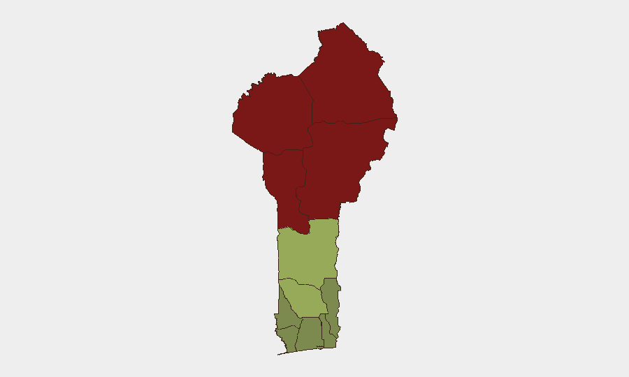
The four northernmost departments—Alibori (92), Atakora (88), Donga (85), and Borgou (83)—account for the majority of Benin's security risk and are driven by proximity to Burkina Faso's unstable zones, jihadist recruitment and transit corridors, and limited state capacity. Zou Department (45) represents a secondary risk band linked to criminal networks and border smuggling. Southern coastal departments (Littoral, Ouémé, Atlantique) remain significantly lower-risk, though they host critical economic infrastructure and diaspora populations requiring standard duty-of-care oversight.
How GeoBit Would Assist
AOI Monitoring & Early Warning focused on Alibori, Atakora, and Donga Departments would provide persistent watch for armed-group movements, recruitment signaling, and cross-border incursions. Multi-language OSINT Fusion & Corroboration (Telegram, X/Twitter, local news aggregation, and radio SIGINT) enables real-time separation of confirmed incidents from noise, critical given the signal-to-clarity ratio in current open sources. Conflict & Military force-structure and Network & Actor Analysis capabilities track Nigeria–Benin coordination effectiveness and jihadist group repositioning, supporting long-term risk trajectory assessment for security teams with personnel or assets in high-risk departments.
7-Day Outlook
Cross-border militant pressure in the north is likely to persist, though no major escalation is forecast in the near term. The formalization of tri-border military coordination may increase reportable security operations (joint patrols, arrests) rather than indicate a spike in violence. Southern and coastal zones should remain stable, but security teams should maintain heightened vigilance for kidnapping or extortion networks operating along main transit corridors linking Nigeria to Benin's interior.
Highest-Risk Areas — Ranked
| # | State / Region | Risk |
|---|---|---|
| 1 | Alibori Department | 92 |
| 2 | Atakora Department | 88 |
| 3 | Donga Department | 85 |
| 4 | Borgou Department | 83 |
| 5 | Zou Department | 45 |
| 6 | Collines Department | 42 |
| 7 | Plateau Department | 38 |
| 8 | Kouffo Department | 35 |
| 9 | Mono Department | 32 |
| 10 | Atlantique Department | 28 |
| 11 | Littoral | 25 |
| 12 | Ouémé Department | 22 |
Sources
Previous Daily Briefs
A new Benin brief is written every day — each with its own risk map and downloadable CSV. Here's the last week; use the calendar to go further back.
📅 Browse every day by calendar →
Highlighted days have a brief. Tap a day for that day's map & analysis, or “csv” for that day's dataset ($5).
Atlas — our AI intelligence desk — emails them this snapshot personally. Nothing else, no list.