Situation Summary
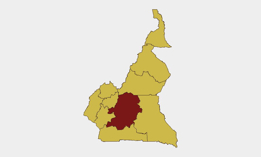
Cameroon remains a composite-threat environment (global rank #19, score 99) with elevated risk concentrated in the Centre region and secondary concerns across the Northwest, Southwest, West, Littoral, and Adamawa zones. Recent activity (22–23 June 2026) reflects institutional challenges—human trafficking, infrastructure decay, and power-sector mismanagement—rather than acute armed conflict or mass civil unrest. The threat trajectory is one of structural fragility rather than destabilization, but operating-environment hazards for corporate personnel remain material.
Key Developments
- Douala (Littoral), 23 June 2026 – Gendarmerie announced dismantling of a major international human-trafficking and fraud network operating under guise of network-marketing firms (Qnet, Ignite, Unimec). Over 6,000 young Cameroonians identified as victims; several coordinators arrested. Signals organized crime and predatory recruitment targeting vulnerable populations.
- Yaoundé (Centre), 23 June 2026 – Severe road degradation at Nkoabang crossroads reported; potholes creating significant traffic disruption and elevated accident risk. Infrastructure condition directly affects circulation safety for corporate road travel in capital region.
- Nationwide, 23 June 2026 – Electricity scandal renewed in public discourse; continued controversy over Globeleq–Eneo mismanagement (100 billion FCFA) and endemic power cuts. Reflects ongoing reliability crisis in critical infrastructure affecting business continuity and duty-of-care operations.
- Douala–Bangui corridor, 23 June 2026 – World Bank approval of 641 billion FCFA for phased rehabilitation of 1,400 km transport route to Central African Republic. Multi-year project intended to improve road safety and transit reliability; near-term construction activity may affect corridor travel and logistics.
- Nationwide (health sector), 23 June 2026 – Continued strain in public health services following USAID funding withdrawal; HIV, TB, and malaria response capacity degraded. Represents evolving health-security risk for expatriate populations and supply-chain resilience.
Highest-Risk Areas
Centre region (risk score 99.2) remains the principal hotspot, driven by institutional fragility, infrastructure decay, and proximity to Yaoundé's political–economic decision-making. The remaining nine regions cluster at 69.2, indicating risk is widely distributed rather than geographically confined; Northwest, Southwest, West, and Littoral—the Anglophone-crisis zones and commercial corridors—maintain elevated secondary concern due to lingering communal tensions, criminal networks (as evidenced by the trafficking dismantling in Douala), and transport-corridor vulnerability. Far-North and Adamawa, while statistically equal to other secondary zones, retain historical exposure to transnational militant activity and should remain on monitoring watch-lists.
How GeoBit Would Assist
Teams managing personnel or assets in Cameroon should deploy AOI Monitoring & Early Warning on Centre region (Yaoundé, Douala) and secondary zones (Northwest, Southwest) to detect escalation in civil unrest, crime networks, or armed activity before widespread impact. Routing & Network Analysis paired with GIS & Spatial Analysis would support real-time alternative-route planning around infrastructure hazards (e.g., Nkoabang crossroads, Douala–Bangui corridor construction zones) and emerging security cordons. Entity & Network Analysis applied to trafficking, fraud, and organized-crime feeds would inform personnel safety briefings and fraud-awareness training in-country.
7-Day Outlook
No indicators of imminent armed escalation or mass unrest are present in available reporting. The near-term risk profile will be shaped by ongoing infrastructure deterioration, power-sector instability, and criminal-network activity rather than state-level conflict. Duty-of-care teams should anticipate continued operational friction from utility cuts, road conditions, and health-system strain, with elevated vigilance for transnational crime and fraud targeting expatriate or corporate networks.
Highest-Risk Areas — Ranked
| # | State / Region | Risk |
|---|---|---|
| 1 | Centre | 99.2 |
| 2 | Northwest | 69.2 |
| 3 | Southwest | 69.2 |
| 4 | West | 69.2 |
| 5 | Littoral | 69.2 |
| 6 | Adamawa | 69.2 |
| 7 | South | 69.2 |
| 8 | Far-North | 69.2 |
| 9 | North | 69.2 |
| 10 | East | 69.2 |
Sources
Previous Daily Briefs
A new Cameroon brief is written every day — each with its own risk map and downloadable CSV. Here's the last week; use the calendar to go further back.
📅 Browse every day by calendar →
Highlighted days have a brief. Tap a day for that day's map & analysis, or “csv” for that day's dataset ($5).