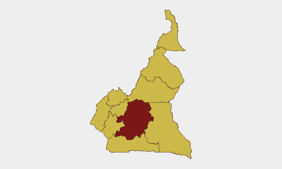
Situation Summary
Cameroon's security environment remains fragmented and multi-layered, with Centre Region—home to the capital Yaoundé—presenting the highest composite threat (97.5), driven by fraud, counterfeiting, and state-control dynamics. The Anglophone crisis in the Northwest and Southwest continues to generate armed-separatist activity and heightened state response, while the Far North faces persistent Boko Haram pressure and gender-based violence linked to ongoing conflict. Recent 24-hour developments signal elevated criminal-fraud activity in urban centers and renewed separatist tensions in periphery zones, with no imminent collapse but sustained multi-domain instability.
Key Developments
- Yaoundé (Centre Region) | 24 June 2026: A man carrying a forged presidential decree attempted to breach CRTV National Station (Nlongkak district), demanding airtime to read the document; he was arrested on-site by security forces. Incident reflects both document-fraud prevalence and potential state-narrative manipulation attempts.
- Yaoundé (Centre Region) | 24 June 2026: Security forces arrested seven suspected counterfeiters and forgers in anti-fraud operation, part of broader crackdown on financial and document crime in the capital.
- Douala (Littoral Region) | 23–24 June 2026: Gendarmerie announced dismantling of major international human-trafficking and fraud network operating under cover of humanitarian/cooperation association; victims targeted with false migration promises. Multi-national criminal nexus indicates organized transnational crime footprint in coastal hub.
- Southwest Region | 24 June 2026: Authorities deployed heightened security measures (reinforced patrols, tighter checkpoints) in response to recent separatist-linked attacks; ongoing Anglophone conflict generating fresh armed incidents and state countermeasures.
- Gulf of Guinea (maritime) | 24 June 2026: U.S. Maritime Administration reiterated 2026-009 advisory on piracy, armed robbery, and kidnapping-for-ransom off Cameroon and neighboring waters; recent kidnappings reported in wider zone signal persistent maritime-security risk to commercial and supply shipping.
- Nationwide | 24 June 2026: Human Rights Watch report highlights government failure to meet 2026 commitment to halve violence against women and girls; insecurity in Anglophone regions and Far North (Boko Haram) exacerbating gender-based-violence risks and blocking access to justice/protection services.
Highest-Risk Areas
Centre Region (97.5 risk score) dominates the threat ranking, reflecting Yaoundé's role as the political and administrative hub where fraud, counterfeiting, and attempted information-control incidents cluster. The nine remaining regions score 67.5 equally, masking significant qualitative differences: Northwest and Southwest (Anglophone zones) are driven by armed separatist activity and state security operations; Far North faces Boko Haram insurgency and associated violence; Littoral (Douala) hosts major transnational crime networks; and South and East remain secondary but monitored. The flattened scoring for regions 2–10 suggests either data-aggregation methodology or persistent low-level instability across periphery zones, warranting granular sub-regional analysis for organizations with concentrated assets.
How GeoBit Would Assist
Teams with personnel or supply chains in Cameroon should employ AOI Monitoring & Early Warning to track Centre Region (Yaoundé/CRTV area), Southwest (separatist flashpoints), and Littoral (Douala port/trafficking nodes) for fresh arrests, armed clashes, and criminal activity. OSINT Fusion & Corroboration (X/Twitter, local media, gendarmerie press releases) would triangulate emerging fraud schemes, counterfeiting operations, and human-trafficking networks before they escalate to direct-threat level. Routing & Network Analysis is essential for maritime and supply-chain teams transiting the Gulf of Guinea, enabling real-time alternative-route planning to avoid piracy/kidnapping zones.
7-Day Outlook
Fraud and counterfeiting operations are likely to persist in urban centers as state crackdowns remain reactive. Separatist activity in Southwest and Northwest will continue generating localized armed clashes and security sweeps, with potential for collateral civilian impact. Maritime piracy risk off Douala remains stable but non-negligible; humanitarian access constraints in Far North and Anglophone zones will likely worsen before any negotiated relief surfaces.
Highest-Risk Areas — Ranked
| # | State / Region | Risk |
|---|---|---|
| 1 | Centre | 97.5 |
| 2 | Northwest | 67.5 |
| 3 | Southwest | 67.5 |
| 4 | West | 67.5 |
| 5 | Littoral | 67.5 |
| 6 | Adamawa | 67.5 |
| 7 | South | 67.5 |
| 8 | Far-North | 67.5 |
| 9 | North | 67.5 |
| 10 | East | 67.5 |
Sources
Previous Daily Briefs
A new Cameroon brief is written every day — each with its own risk map and downloadable CSV. Here's the last week; use the calendar to go further back.
📅 Browse every day by calendar →
Highlighted days have a brief. Tap a day for that day's map & analysis, or “csv” for that day's dataset ($5).