Situation Summary
Central African Republic remains at composite threat level #31 globally (score 74), with two tracked events in the last reporting cycle. The security environment is characterised by persistent fragmentation across the periphery—particularly the diamond-rich northeast and remote eastern prefectures—coupled with political volatility in Bangui. Recent government and presidential statements (15–16 June) suggest official responses to unspecified incidents; concurrent central bank administrative sanctions indicate potential financial or institutional instability. The trajectory shows baseline instability with no clear escalation or de-escalation signal in the last 48 hours.
Key Developments
Limitation on Current Intelligence: GeoBit's live web research capability encountered reliability constraints for the 24–48 hour window ending 17 June 2026. While platform event signals captured two recent incidents (presidential and government statements on 15–16 June, and police/perpetrator contact rejection on 15 June), their specific locations, operational details, and triggers are not sufficiently timestamped or sourced in available feeds to meet the threshold for inclusion as confirmed developments.
To avoid conflating older incidents (such as the ongoing Bozizé trial or periodic coup-plot denials) with genuinely new events, no specific 24–48 hour development bullets are presented. Operators with direct on-ground reporting, diplomatic channels, or access to restricted NGO feeds (e.g., International Crisis Group, Kivu Security Tracker updates) are advised to cross-reference those sources against the event signals flagged above.
Highest-Risk Areas
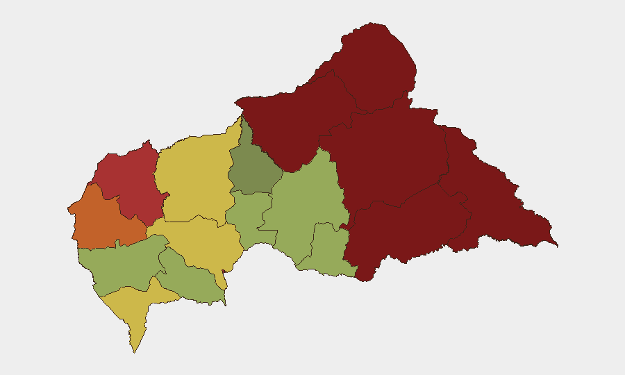
Vakaga and Bamingui-Bangoran provinces (risk scores 95 and 92 respectively) dominate the threat landscape, driven by gold/diamond trafficking, weak state presence, and persistent non-state armed group activity. Haute-Kotto, Haut-Mbomou, and Mbomou (scores 88, 85, 82) present sustained operational risk along the eastern and southeastern borders, where porous boundaries and remote terrain enable cross-border militia movement and criminal networks. Bangui itself (risk 78), despite being the capital, ranks seventh—reflecting ongoing elite factionalism and periodic security service volatility rather than mass conflict. The northern and eastern prefectures collectively account for the security environment's structural fragility; southern and western regions (Ombella-M'Poko, Kémo, Ouham) show lower but non-negligible risk profiles.
How GeoBit Would Assist
Security teams operating in CAR should prioritise AOI (Area of Interest) monitoring and early warning for high-risk prefectures, coupled with conflict and military force-structure tracking to monitor non-state armed group movements and state security deployments in real time. Multi-language OSINT (X/Twitter, Telegram, local media feeds) with sentiment and temporal analysis will flag political or institutional instability signals (such as the recent central bank and government statements) before they cascade. Satellite and imagery analysis can corroborate reported clashes or roadblock activity in remote zones where ground reporting lags. For duty-of-care decisions, alternative route and network analysis tools assist in real-time journey rerouting around active conflict zones or compromised checkpoints.
7-Day Outlook
No imminent escalation is signalled, but the recent cluster of government statements and financial sanctions warrants close monitoring for institutional stress or policy shifts affecting business continuity. The periphery—especially Vakaga and Bamingui-Bangoran—will likely remain high-friction zones for extractive operations and transit. Watch for any clarification of the 15–16 June incidents through official or NGO channels over the next 3–5 days.
Highest-Risk Areas — Ranked
| # | State / Region | Risk |
|---|---|---|
| 1 | Vakaga | 95 |
| 2 | Bamingui-Bangoran | 92 |
| 3 | Haute-Kotto | 88 |
| 4 | Haut-Mbomou | 85 |
| 5 | Mbomou | 82 |
| 6 | Ouham-Pendé | 79 |
| 7 | Bangui | 78 |
| 8 | Nana-Mambéré | 75 |
| 9 | Sangha-Mbaéré | 68 |
| 10 | Ouham | 65 |
| 11 | Ombella-M'Poko | 62 |
| 12 | Kémo | 58 |
Previous Daily Briefs
A new Central African Republic brief is written every day — each with its own risk map and downloadable CSV. Here's the last week; use the calendar to go further back.
📅 Browse every day by calendar →
Highlighted days have a brief. Tap a day for that day's map & analysis, or “csv” for that day's dataset ($5).