Situation Summary
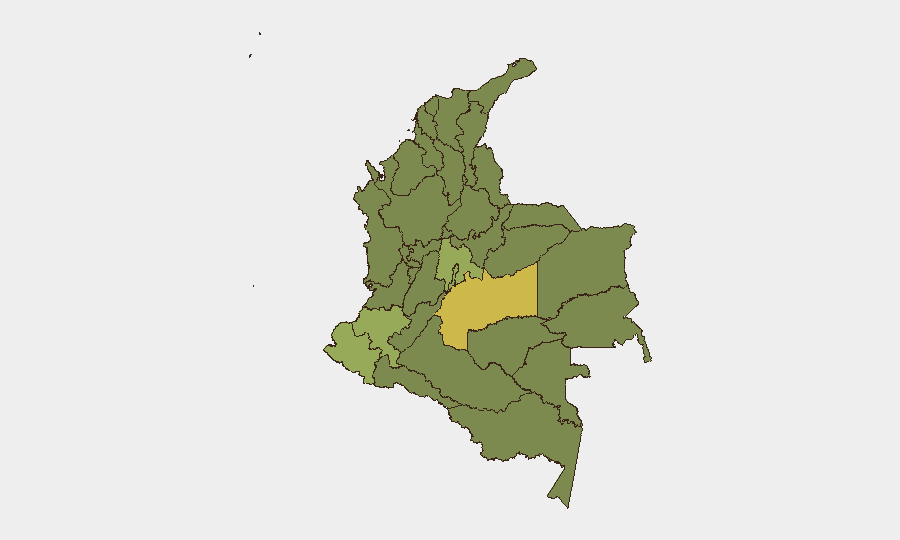
Colombia remains at composite threat level #35 globally (score 59/100), with 242 tracked security events reflecting elevated political friction, selective armed-group activity, and institutional stress. The country's risk profile is heavily concentrated in southern and southwestern departments, where coca production, illegal armed competition, and border instability compound governance challenges. The past 48 hours show signals of political contestation and small-scale armed clashes, but no nationwide escalation or systemic breakdown. The trajectory remains volatile but contained to known hotspots.
Key Developments
- 2026-06-17 · Small Arms Combat · Dissident vs. Military — Armed dissidents engaged military forces in a localized firefight; location and casualty data not yet specified in open reporting.
- 2026-06-17 · Conventional Military Force · Guerrilla Activity — Guerrilla-affiliated armed group activity detected; specific region and tactical details pending corroboration.
- 2026-06-17 · Admin Sanctions · Presidential Action vs. Television — President issued administrative sanctions against a television outlet, signaling media-governance friction.
- 2026-06-17 · Arrest/Detain · Judicial Action — Judge-ordered detention related to alleged violation of publication/speech rights; institutional pressure on press freedom evident.
- 2026-06-16 · Conventional Military Force · Fighter vs. Army — Armed clash between non-state fighter and Colombian military reported.
- 2026-06-16 · Arrest/Detain · External Actor — Vladivostok-linked entity arrested in Colombia; trafficking, sanctions evasion, or criminal-network investigation likely driver.
*Note: Detailed geographic anchors and casualty counts not available in current intelligence feed; verification and location-specificity recommended via real-time regional news sources and Policía Nacional alerts.*
Highest-Risk Areas
Meta Department (risk 63.9) and Nariño (risk 55.1) drive the country's threat profile, both characterized by coca cultivation, competing illegal armed control, and weak state presence. Capital District (43.3) and Cundinamarca (43) reflect urban crime, organized-crime presence, and political/institutional tension in and around Bogotá. Cauca (40.1) and Valle del Cauca (37.1) remain flashpoints for armed-group territorial competition and supply-chain violence. The concentration of risk in the south and southwest reflects the geography of drug production, cross-border trafficking pressure from Ecuador, and the fragmented successor landscape of the original FARC organization.
How GeoBit Would Assist
AOI Monitoring & Early Warning would track persistent threat signatures in Meta, Nariño, and Cauca, with alerting on armed-group movement, roadblock activity, and military operations. Conflict & Military mapping combined with Network & Actor Analysis enables real-time force-structure and leadership tracking of FARC dissidents, ELN, and Clan del Golfo cells. Election Monitoring and Sentiment & Temporal Analysis on Colombian media and X/Twitter OSINT would flag political escalation, civil unrest signals, and institutional stress before they reach operational threshold.
7-Day Outlook
Small-scale armed clashes and political friction are expected to persist in Meta, Nariño, and Cauca over the next week, driven by coca-harvest competition and state interdiction operations. No imminent nationwide instability or capital-region security collapse is signaled, but localized supply-chain disruption, road closures, and isolated violence in high-risk departments remain probable. Personnel and asset movements in southern departments should remain subject to heightened vetting and route-planning review.
Highest-Risk Areas — Ranked
| # | State / Region | Risk |
|---|---|---|
| 1 | Meta Department | 63.9 |
| 2 | Nariño | 55.1 |
| 3 | Capital District | 43.3 |
| 4 | Cundinamarca Department | 43 |
| 5 | Cauca | 40.1 |
| 6 | Valle del Cauca Department | 37.1 |
| 7 | Antioquia Department | 35.5 |
| 8 | Atlántico Department | 34.6 |
| 9 | Chocó Department | 34.6 |
| 10 | Santander Department | 34.6 |
| 11 | Tolima Department | 34.3 |
| 12 | La Guajira | 34.1 |
Sources
Previous Daily Briefs
A new Colombia brief is written every day — each with its own risk map and downloadable CSV. Here's the last week; use the calendar to go further back.
📅 Browse every day by calendar →
Highlighted days have a brief. Tap a day for that day's map & analysis, or “csv” for that day's dataset ($5).