Situation Summary
Colombia remains at composite threat rank #34 globally, with insurgency and armed-group activity as primary drivers. Election security preparations are intensifying ahead of the June 21 presidential runoff, with nationwide deployment of police and election monitoring in place. Armed-group membership has nearly doubled since 2022 (to ~25,000), affecting roughly one-quarter of Colombian municipalities; baseline violence metrics (massacres, homicides, kidnappings) remain elevated year-on-year. The security environment is stable operationally in most urban centers but remains high-risk in conflict-affected rural zones, particularly in the southwest and border regions.
Key Developments
- Bogotá (nationwide) – June 18, 2026 – Electoral security deployment active: ~12,500 police officers plus ~2,500 district officials deployed across capital's 20 localities for June 21 runoff; Unified Command Post established to monitor critical infrastructure (electricity, telecoms, water, transport). Alcohol restrictions (*ley seca*) now in effect from 00:00 June 20 through midday June 22.
- Nationwide – June 18, 2026 – National security assessment confirms illegal armed-group membership has risen from ~13,000 (2022) to ~25,000 (H1 2026), with presence/activity reported in approximately 25% of municipalities. Ministry reports ~16,000 armed-group members neutralized (captures/surrenders) in current administration cycle.
- Southwest Colombia (Cauca, Valle del Cauca, Nariño) – through mid-June, re-emphasized June 18 – FARC dissident structures credited with 31 attacks in these departments during early 2026, resulting in dozens of civilian casualties. Analysts assess elevated risk of follow-on attacks in rural zones with limited state presence, particularly as election period approaches.
- Catatumbo region, Norte de Santander – ongoing, mid-June reporting – Armed groups maintaining operational control via road checkpoints, curfews, and reported drone strikes in coca-growing areas near Venezuelan border. Travel conditions remain severely constrained.
- Nationwide (vulnerable populations) – mid-June alerts re-circulated June 18–19 – Amnesty International and Colombian human-rights organizations report continued threats and violent attacks against women human-rights defenders ("searchers" investigating disappearances) across conflict-affected regions, with impunity concerns cited.
- January–April baseline metrics cited June 18 – Documented 48 massacres (229 deaths) in first four months of 2026; year-on-year increases in homicides, massacres, kidnappings, and extortion noted since 2024, establishing high baseline risk for contested rural travel corridors.
Highest-Risk Areas
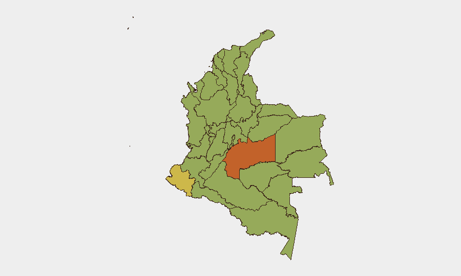
Meta Department (#1, risk 75.8) and Nariño (#2, risk 69.3) are the highest-risk sub-national zones, driven by active FARC dissident operations, illegal mining, and coca cultivation. Capital District (59.2) elevates risk due to concentration of state assets and electoral activity; Cundinamarca (58) and Cauca (54) remain volatile due to rural armed-group presence. The southwest cluster (Cauca, Valle del Cauca, Nariño) and border regions (Catatumbo/Norte de Santander) account for the majority of recent violent incidents and represent the principal threat to corporate travel and field operations.
How GeoBit Would Assist
Real-time Election Monitoring and AOI Monitoring & Early Warning capabilities would track election-day disruptions and armed-group activity across high-risk departments, with alerting on specific incidents in Meta, Nariño, and Cauca. Routing & Network Analysis would identify secure alternative routes for personnel and supply movement, avoiding Catatumbo checkpoints and contested rural corridors. OSINT Fusion & Corroboration (X/Twitter, local police/municipal feeds, NGO data) would separate confirmed incidents from rumors, reducing false alarms and improving decision cycle.
7-Day Outlook
The June 21 runoff will likely proceed with elevated police presence in urban centers; rural violence risk remains persistent but unlikely to spike dramatically before election day. Post-runoff period (June 22–30) carries higher uncertainty as armed groups may test new government legitimacy or security posture; continued monitoring of Meta, Nariño, and southwest departments is essential.
Highest-Risk Areas — Ranked
| # | State / Region | Risk |
|---|---|---|
| 1 | Meta Department | 75.8 |
| 2 | Nariño | 69.3 |
| 3 | Capital District | 59.2 |
| 4 | Cundinamarca Department | 58 |
| 5 | Cauca | 54 |
| 6 | Santander Department | 50.7 |
| 7 | Antioquia Department | 49.2 |
| 8 | Atlántico Department | 48.9 |
| 9 | Chocó Department | 46.8 |
| 10 | Valle del Cauca Department | 46.5 |
| 11 | Tolima Department | 46.5 |
| 12 | Magdalena Department | 46.2 |
Sources
Previous Daily Briefs
A new Colombia brief is written every day — each with its own risk map and downloadable CSV. Here's the last week; use the calendar to go further back.
📅 Browse every day by calendar →
Highlighted days have a brief. Tap a day for that day's map & analysis, or “csv” for that day's dataset ($5).