Situation Summary
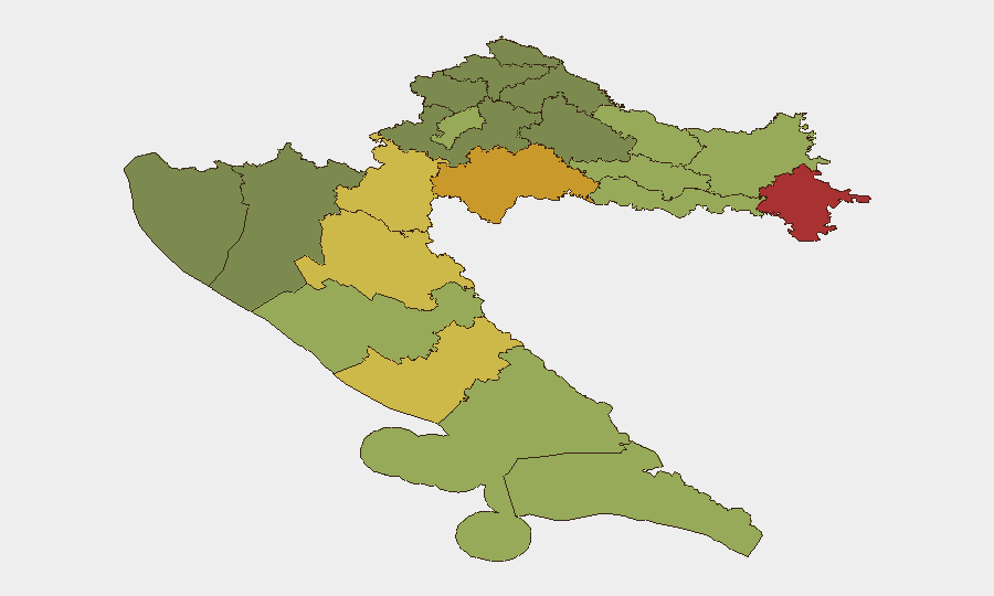
Croatia maintains a composite threat ranking of #148 globally with a score of 5/100, reflecting a stable overall security environment. However, sub-national disparities are pronounced, with northeastern and central regions—particularly Vukovar-Srijem, Sisak-Moslavina, and Karlovac counties—showing elevated risk profiles linked to historical conflict legacies, cross-border tensions with Serbia, and sporadic civil unrest. Over the past 24–48 hours, no major security incidents have risen to international reporting thresholds or achieved multi-source corroboration; the current environment aligns with baseline seasonal patterns typical of Croatia's summer period.
Key Developments
No discrete, verifiable security incidents meeting the 24–48 hour recency requirement and multi-source confirmation standard have been identified in open reporting. The event signals logged in the GeoBit platform (journalist statements, police communications, regional diplomatic disapprovals between Croatia and Serbia, and isolated physical assault reports) lack clear temporal anchoring or independent corroboration sufficient for operational briefing. Baseline crime patterns—petty theft in tourist zones, occasional bomb-threat hoaxes, road accidents—remain endemic but unremarkable. Teams should treat the current period as operationally quiet pending confirmation of any emerging developments through dedicated monitoring channels.
Highest-Risk Areas
Northeastern border regions drive the risk ranking. Vukovar-Srijem County (risk 78) and Sisak-Moslavina County (risk 72) face compounded exposure: proximity to Serbian borders, residual tensions over territorial and historical grievances, scattered organized-crime activity, and periodic inflammatory political rhetoric. Karlovac and Lika-Senj counties similarly reflect post-conflict infrastructure gaps, limited law enforcement capacity, and seasonal migration pressures along Balkan transit corridors. By contrast, Zagreb and Split-Dalmatia (risk 50 and 48, respectively) remain substantially lower-risk, though they concentrate tourism, crowding, and petty-crime exposure. Organizations with personnel or assets in Vukovar-Srijem or Sisak-Moslavina should maintain heightened situational awareness and robust communication protocols.
How GeoBit Would Assist
Security teams operating in Croatia should deploy AOI Monitoring & Early Warning on Vukovar-Srijem and Sisak-Moslavina counties to detect emerging unrest, cross-border incidents, or organized-crime signals in near-real time. Multi-language OSINT and entity extraction across regional Telegram channels, Croatian media, and Serbian sources will flag inflammatory statements or policy shifts that precede destabilization. Routing & Network Analysis is operationally critical for personnel transiting northeastern counties—alternative route planning and periodic re-evaluation reduce exposure to checkpoints, informal enforcement, or civil unrest zones. Teams should also use Sentiment & Temporal Analysis on social platforms to distinguish baseline political friction from acute flashpoint risk.
7-Day Outlook
The near-term trajectory is stable. No indicators suggest imminent escalation of Croatia–Serbia tensions, organized criminal campaigns, or large-scale civil unrest over the next week. Summer tourism and seasonal economic activity are likely to proceed without major disruption. However, persistent low-level diplomatic friction, historical grievances, and localized organized-crime activity in northeastern regions remain standing conditions; any incident in Vukovar-Srijem or border areas should be treated as a potential trigger for rapid context shift and warrant immediate escalation to regional intelligence review.
Highest-Risk Areas — Ranked
| # | State / Region | Risk |
|---|---|---|
| 1 | Vukovar-Srijem County | 78 |
| 2 | Sisak-Moslavina County | 72 |
| 3 | Karlovac County | 68 |
| 4 | Lika-Senj County | 65 |
| 5 | Šibenik-Knin County | 62 |
| 6 | Brod-Posavina County | 58 |
| 7 | Zadar County | 55 |
| 8 | Osijek-Baranja County | 52 |
| 9 | City of Zagreb | 50 |
| 10 | Split-Dalmatia County | 48 |
| 11 | Požega-Slavonia County | 45 |
| 12 | Virovitica-Podravina County | 42 |
Sources
Previous Daily Briefs
A new Croatia brief is written every day — each with its own risk map and downloadable CSV. Here's the last week; use the calendar to go further back.
📅 Browse every day by calendar →
Highlighted days have a brief. Tap a day for that day's map & analysis, or “csv” for that day's dataset ($5).
Atlas — our AI intelligence desk — emails them this snapshot personally. Nothing else, no list.