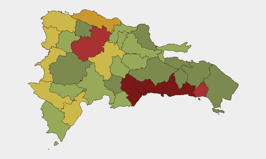
Situation Summary
The Dominican Republic remains at moderate overall risk (global rank #61, composite score 20) with no verifiable security, conflict, or civil unrest incidents reported in the last 24–48 hours. Seismic activity—three earthquakes (M 3.3–3.9) near Punta Cana in recent days—and an active wildfire in the interior are being tracked but have not yet produced casualty reports or major infrastructure disruption in available sources. The country's security posture is stable; however, concentrated gang and narcotics activity in urban centers, particularly Santo Domingo and the Nacional District, continues to drive elevated sub-national risk scores.
Key Developments
- Seismic Events (Last 48–72 hours, Eastern Dominican Republic): Three earthquakes recorded near Punta Cana (M 3.9 at 87 km NNE; M 3.7 at 36 km SSE; M 3.3 at 89 km N). No casualty or damage reports in tourism zones or major cities as of 07-07. Monitoring status: ongoing.
- Active Wildfire (Interior, Dominican Republic): Wildfire event 1029053 flagged in recent satellite/environmental data. Specific location and containment status not yet clarified in open sources. Risk to inhabited areas and critical infrastructure TBD.
- No Major Crime/Unrest Incidents (Last 24–48 hours): Web and social media searches (X, local news, NGO reports) returned no confirmed reports of significant carjackings, kidnappings, gang violence escalation, road blockades, or protest activity during July 5–7, 2026.
- Background Context (Ongoing, not new): Gang activity and narcotics trafficking remain endemic to Santo Domingo, San Pedro de Macorís, and Santiago; rates of street crime (robbery, assault) in these zones remain elevated year-round. This is a chronic condition, not a new event.
Highest-Risk Areas
Santo Domingo (risk 92) and the Nacional District (risk 88) drive the country's overall sub-national threat profile, reflecting persistent gang presence, narcotics distribution networks, and petty-to-serious street crime. San Cristóbal, San Pedro de Macorís, and La Romana (risk scores 85, 83, 78 respectively) follow, with San Pedro particularly sensitive due to port activity and drug-trafficking routes. Border provinces (Elías Piña, Dajabón, Independencia) carry moderate-to-elevated risk due to contraband and informal-economy activity; however, organized conflict or state-level instability is not evident. Mid-tier tourist destinations (Puerto Plata, La Vega) maintain lower risk but warrant standard travel/duty-of-care protocols.
How GeoBit Would Assist
Corporate security teams can employ AOI Monitoring & Early Warning to track Santo Domingo, San Pedro de Macorís, and border provinces for sudden escalations in crime, civil unrest, or infrastructure disruption. Intel Sweep and X/Telegram OSINT capabilities enable real-time monitoring of gang activity, cartel statements, and local reporting in Spanish; Sentiment & Temporal Analysis can flag emerging protest or instability signals before mainstream media coverage. Satellite & Imagery Analysis and Environmental & Health modules provide early detection of disasters (wildfire spread, flooding, power outages) that may isolate or endanger personnel.
7-Day Outlook
No major security escalation is anticipated in the next seven days based on current baseline conditions and seismic/environmental data. However, teams should maintain heightened awareness in Santo Domingo and San Pedro de Macorís during evening and night hours; wildfire containment and any aftershock activity warrant continued monitoring. Standard transit security protocols (avoid isolated routes, limit late-night movement, maintain situational awareness in urban centers) remain in effect.
Highest-Risk Areas — Ranked
| # | State / Region | Risk |
|---|---|---|
| 1 | Santo Domingo | 92 |
| 2 | Nacional District | 88 |
| 3 | San Cristóbal | 85 |
| 4 | San Pedro de Macorís | 83 |
| 5 | La Romana | 78 |
| 6 | Santiago | 76 |
| 7 | Puerto Plata | 72 |
| 8 | Elías Piña | 70 |
| 9 | Dajabón | 68 |
| 10 | Barahona | 65 |
| 11 | Independencia Province | 64 |
| 12 | La Vega | 62 |
Sources
Previous Daily Briefs
A new Dominican Republic brief is written every day — each with its own risk map and downloadable CSV. Here's the last week; use the calendar to go further back.
📅 Browse every day by calendar →
Highlighted days have a brief. Tap a day for that day's map & analysis, or “csv” for that day's dataset ($5).
Atlas — our AI intelligence desk — emails them this snapshot personally. Nothing else, no list.