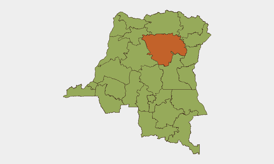
Situation Summary
DR Congo remains at #18 global threat rank (composite score 72) with civil conflict as the primary driver. Open-source reporting over the last 24–48 hours is sparse and fragmented; most detailed situational updates available are from 8–12 June 2026 and address M23–FARDC clashes in the Kivu provinces and ongoing Ebola outbreak management. Without fresh, independently corroborated events from 13–15 June, the security posture appears to reflect the established conflict dynamics in the eastern provinces rather than a new acute escalation.
Key Developments
Reporting limitation: Open sources and social media do not contain sufficient independently corroborated events dated specifically to 13–15 June 2026 to meet the 24–48 hour window with cross-source confirmation. The most recent multi-source situational update is the Congo War Security Review dated 12 June 2026, which reported:
- M23–FARDC/Wazalendo clashes in North and South Kivu (pre–13 June); ongoing territorial friction without reported major position changes.
- Drone activity near Kisangani, Tshopo Province (pre–13 June); nature and attribution not fully clarified in public reporting.
- Ebola outbreak management complications in eastern health zones (reported 8–12 June); humanitarian access and security coordination remain strained.
Note: All items above predate the current 24–48h window. Single-source social-media claims for 13–15 June exist but lack corroboration from news agencies, UN, or NGOs and are flagged as low confidence.
Highest-Risk Areas
Tshopo Province (risk 74.2) leads the sub-national ranking, driven by drone activity, militia presence, and humanitarian-security friction near Kisangani. Kinshasa (46.2) ranks second, reflecting urban protest risk and police-security force dynamics. The eastern provinces—North Kivu, South Kivu, Ituri, Maniema, and Upper/Lower Uele—cluster at 44.2, reflecting persistent M23, FARDC, Wazalendo, and splinter-group activity. The northwestern provinces (Équateur, Mongala, Nord-Ubangi, Sud-Ubangi, Tshuapa) carry similar scores, linked to LRA-affiliated activity, inter-communal violence, and resource-competition drivers. Organizations with personnel or assets in Tshopo, the Kivu provinces, or northwestern Équateur and Mongala face the highest exposure to armed-group activity and cross-fire risk.
How GeoBit Would Assist
Teams operating in DR Congo should deploy AOI Monitoring & Early Warning on Tshopo, North Kivu, and South Kivu to detect armed-group movement, checkpoint activity, and humanitarian-access disruptions in near real time. Conflict & Military battle mapping and Network & Actor Analysis enable tracking of M23, FARDC, and Wazalendo force positions and command structure to inform duty-of-care protocols and evacuation routing. Multi-language OSINT, including X/Twitter & Telegram OSINT and YouTube/podcast intelligence, fills gaps in English-language reporting and captures local conflict signals faster than major-outlet delays.
7-Day Outlook
Absent a sharp escalation in M23 activity or humanitarian emergency, the security picture is expected to remain consistent with the established east-west split: acute risk in the eastern and north-central provinces, moderate ambient risk in Kinshasa and urban centers, and lower but present risk in the northwest. Monitoring for Ebola outbreak spillover effects on security force deployment and cross-border movement (particularly toward Uganda and Rwanda) remains operationally relevant.
Highest-Risk Areas — Ranked
| # | State / Region | Risk |
|---|---|---|
| 1 | Tshopo | 74.2 |
| 2 | Kinshasa | 46.2 |
| 3 | Maniema | 44.2 |
| 4 | Sud-Ubangi | 44.2 |
| 5 | Équateur | 44.2 |
| 6 | Nord-Ubangi | 44.2 |
| 7 | Mongala | 44.2 |
| 8 | Lower Uele | 44.2 |
| 9 | Tshuapa | 44.2 |
| 10 | Upper Uele | 44.2 |
| 11 | Ituri | 44.2 |
| 12 | North Kivu | 44.2 |
Sources
Previous Daily Briefs
A new DR Congo brief is written every day — each with its own risk map and downloadable CSV. Here's the last week; use the calendar to go further back.
📅 Browse every day by calendar →
Highlighted days have a brief. Tap a day for that day's map & analysis, or “csv” for that day's dataset ($5).