Situation Summary
Eritrea remains a low-frequency threat environment (global rank #72) with no credible reports of armed clashes, civil unrest, major crime, or infrastructure attacks inside the country in the last 24–48 hours. However, the security picture is shaped by heightened regional dynamics: diplomatic activity signals Eritrean sensitivity to external maritime interference in the Red Sea, while documented Eritrean Defense Forces presence inside neighboring Ethiopia and renewed troop mobilization along the Tigray frontier sustain elevated cross-border conflict risk. The overland access routes to Eritrea through northern Ethiopia remain heavily militarized and landmine-contaminated, creating operational friction for duty-of-care planning.
Key Developments
- Asmara, 19 July 2026 – Egypt's foreign minister and Eritrean counterpart Osman Saleh issued a joint statement rejecting "any attempts by non‑littoral parties to enforce maritime access or impose security arrangements in the Red Sea," signaling Eritrea's resistance to external naval security frameworks in adjacent waters and reaffirming coastal-state authority over Red Sea security governance.
- Asmara, 17 July 2026 – Sudan's military leader Gen. Abdel Fattah al‑Burhan conducted bilateral talks with President Isaias Afwerki on regional security, bilateral relations, and Sudan's internal situation, occurring against a backdrop of Horn of Africa tensions and ongoing concern over potential renewed Eritrea–Ethiopia conflict.
- Ethiopia–Eritrea frontier, northern Ethiopia side, updated through 19 July 2026 – Security analysis confirms sustained Eritrean Defense Forces deployment inside Ethiopian territory, continued troop mobilization along Tigray's borders, and documented landmine risk, maintaining a heavily militarized frontier with elevated spillover potential into Eritrean border regions.
- Eritrea (general), 19 July 2026 – Open-source monitoring (web, social media) confirms no credible reports of new armed clashes, civil unrest, major crime incidents, or infrastructure attacks inside Eritrea in the last 24–48 hours; however, tight information controls and limited independent media create high likelihood of under-reporting of small-scale incidents.
- Northern Ethiopia–Eritrean frontier (overland access routes), mid-July 2026 assessment – Country-risk and government travel advisories emphasize that heightened armed-actor activity, landmines, and unresolved conflict dynamics in northern Ethiopia create an "unusually dense duty-of-care challenge" for organizations planning overland travel to/from Eritrea via neighboring conflict zones.
Highest-Risk Areas
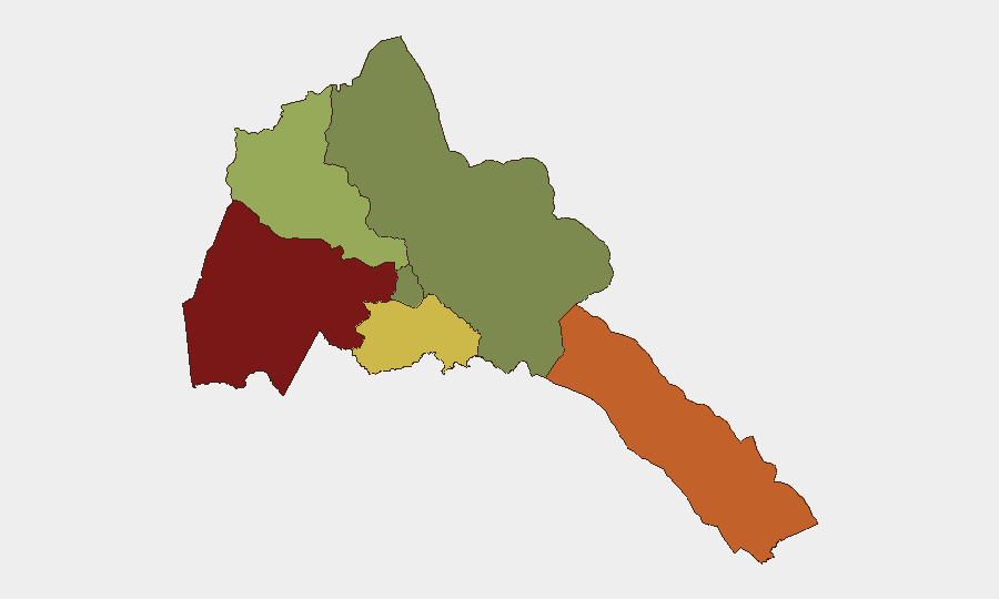
Gash-Barka (risk score 92) and the Southern Red Sea Region (75) dominate the sub-national threat profile and are driven by proximity to the Ethiopia–Eritrea frontier, militarization, landmine contamination, and the documented presence of armed actors from multiple state and non-state entities. Debub Region (68) carries secondary risk from similar border dynamics. Maekel Region, which includes Asmara, remains the lowest-risk zone (18) and continues to host diplomatic and governmental activity with minimal incident reporting. The concentration of risk in border and maritime zones reflects Eritrea's geopolitical position and exposure to regional conflict spillover rather than internal instability.
How GeoBit Would Assist
Security teams monitoring Eritrea should deploy AOI Monitoring & Early Warning on the Gash-Barka and border regions to detect shifts in military activity, armed-actor positioning, and landmine incidents affecting overland access. OSINT fusion and multi-language search (X/Twitter, Telegram, regional media) across 24–48-hour cycles will catch under-reported small-scale incidents and diplomatic signaling. Routing & Network Analysis capabilities enable duty-of-care teams to model safe overland entry/exit routes around documented conflict zones and to refresh contingency evacuation corridors as frontier conditions shift.
7-Day Outlook
No imminent internal security crisis inside Eritrea is forecast, but cross-border risk remains elevated due to ongoing EDF deployment in Ethiopia and renewal of Horn of Africa tensions. Diplomatic activity (Egypt–Eritrea, Sudan–Eritrea) will likely continue to frame Eritrea's strategic posture but is unlikely to trigger immediate operational incidents. Overland access risk will persist; maritime security rhetoric may intensify without corresponding incident activity in the coming week.
Highest-Risk Areas — Ranked
| # | State / Region | Risk |
|---|---|---|
| 1 | Gash-Barka | 92 |
| 2 | Southern Red Sea Region | 75 |
| 3 | Debub Region | 68 |
| 4 | Anseba | 55 |
| 5 | Maekel Region | 18 |
| 6 | Northen Red Sea Region | 0 |
Sources
Previous Daily Briefs
A new Eritrea brief is written every day — each with its own risk map and downloadable CSV. Here's the last week; use the calendar to go further back.
📅 Browse every day by calendar →
Highlighted days have a brief. Tap a day for that day's map & analysis, or “csv” for that day's dataset ($5).
Atlas — our AI intelligence desk — emails them this snapshot personally. Nothing else, no list.