Situation Summary
Ethiopia remains in active civil conflict characterized by multi-front military operations, federal-militia clashes, and cross-border tensions with Sudan and Eritrea. The security environment is deteriorating along the western frontier and in northern regions, with escalating drone strikes, artillery exchanges, and renewed political-military friction between federal forces and the TPLF. Current trajectory indicates sustained or heightened volatility through at least mid-July, driven by competing claims of aggression and restocked military positions.
Key Developments
- Sudan-Ethiopia Border (West Gallabat / Basunda) — 21 June 2026 — Sudan's military accused Ethiopia of conducting a drone attack on border positions; Ethiopia denied involvement and counter-accused Sudan's Armed Forces of backing Tigrayan fighters. This marks the most recent escalation in a pattern of cross-border drone and artillery exchanges dating to May 2026.
- Northern Ethiopia / Tigray — 18 June 2026 — U.S. State Department announced targeted visa restrictions on individuals undermining Ethiopia's peace process, citing escalating tensions between federal government and TPLF hardliners and warning of renewed armed conflict risk in the north.
- Tigray Political Control — May 2026 — TPLF reasserted administrative control of Tigray Region and restored its legislative council, a development publicly linked by Washington to rising federal-TPLF friction and military repositioning.
- Amhara, Oromia, Tigray (Multi-Region) — Ongoing through June 2026 — Continuous reports of drone strikes, artillery bombardment, abductions, and arbitrary detention across conflict zones; exact incident counts and locations remain fragmented in open reporting.
- Western Frontier Militarization — 7 May – 21 June 2026 — Sudan reinforced border positions in response to earlier drone attacks; Ethiopia has not reciprocally disclosed formal defensive repositioning, creating asymmetric escalation risk.
Highest-Risk Areas
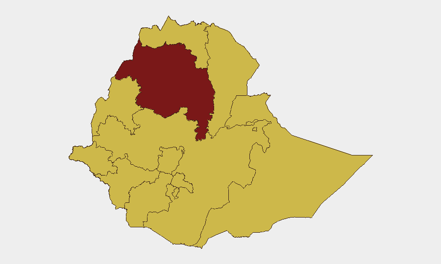
Amhara Region (91.9) and Addis Ababa (87.7) represent the composite threat peak, reflecting active federal-militia combat, internal security operations, and capital-level political tension. Tigray (66.2) and Oromia (66.2) remain acute secondary theaters, where TPLF repositioning and inter-communal armed groups sustain persistent violence. The western and southwestern peripheries (Benishangul-Gumuz, Afar, South West Ethiopia Peoples, all ≥61.9) show lower individual scores but collectively represent a diffuse and fragmented threat surface where border instability, pastoralist conflict, and militia activity converge. Risk concentration in Amhara and the capital reflects federal authority contestation and state-level military operations.
How GeoBit Would Assist
Corporate security and duty-of-care teams operating in Ethiopia should leverage AOI Monitoring & Early Warning for real-time alerts on conflict movement in Amhara, Tigray, and Oromia; Conflict & Military battle mapping and force-structure tracking to understand federal and militia positioning; and Routing & Network Analysis to identify safe corridors and alternative logistics pathways around active conflict zones. Complementary OSINT fusion & corroboration and multi-language search capabilities enable continuous monitoring of Telegram, X, and local media for incident confirmation before relying on unverified reports. Satellite & Imagery analysis and GIS & Spatial Analysis provide granular location intelligence for site-specific risk assessment.
7-Day Outlook
Sudan-Ethiopia border tensions are likely to persist or escalate absent immediate diplomatic intervention; further cross-border drone or artillery exchanges carry non-negligible risk. Federal-TPLF friction will sustain elevated military posture in Tigray and northern Amhara through at least late June. Operational security for international staff and supply chains should assume continued disruption in northern corridors and heightened checkpoint activity.
Highest-Risk Areas — Ranked
| # | State / Region | Risk |
|---|---|---|
| 1 | Amhara Region | 91.9 |
| 2 | Addis Ababa | 87.7 |
| 3 | Tigray | 66.2 |
| 4 | Oromia Region | 66.2 |
| 5 | South West Ethiopia Peoples | 64.1 |
| 6 | Central Ethiopia Regional State | 64.1 |
| 7 | Afar Region | 61.9 |
| 8 | Benishangul-Gumuz Region | 61.9 |
| 9 | Somali Region | 61.9 |
| 10 | Gambela Region | 61.9 |
| 11 | South Ethiopia Regional State | 61.9 |
| 12 | Sidama | 61.9 |
Sources
Previous Daily Briefs
A new Ethiopia brief is written every day — each with its own risk map and downloadable CSV. Here's the last week; use the calendar to go further back.
📅 Browse every day by calendar →
Highlighted days have a brief. Tap a day for that day's map & analysis, or “csv” for that day's dataset ($5).