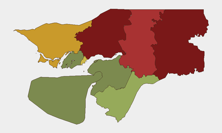
Situation Summary
Guinea-Bissau remains in a structurally fragile state following the November 2025 military seizure of power and detention of senior civilian leaders. No new security incidents have been confirmed in the last 24–48 hours at the national or regional level. The country's security posture is characterized by chronic institutional weakness, porous borders in the north, and irregular migration networks rather than by acute conflict or civil unrest at this time.
Key Developments
No verifiable security, political, crime, or civil-unrest incidents meeting professional intelligence corroboration standards have been reported in Guinea-Bissau during the 2–4 August 2026 window.
Open-source monitoring of national media, social platforms, and regional security feeds has yielded no dated reports of armed clashes, demonstrations, curfews, border incidents, or transport disruptions initiated in the last 24–48 hours.
Northern border regions (Gabu, Oio, Bafatá) showed no confirmed spillover activity from neighboring West African states or refugee movements during this period, despite their structural vulnerability to transnational crime and irregular migration.
Bissau city recorded no corroborated reports of civil unrest, criminal escalation, or political agitation in the last 24–48 hours.
The political environment remains uncertain but currently calm; no coup attempts, power transitions, or mass mobilizations have been reported beyond the post-November 2025 baseline.
Highest-Risk Areas
Gabu Region (risk score 92) and Oio Region (85) dominate the risk profile, driven by weak state capacity, proximity to Senegal and Guinea, and documented trafficking of persons, narcotics, and weapons across porous borders. Bafatá Region (78) and Cacheu Region (72) present secondary but significant risk from similar cross-border vulnerabilities and irregular migration flows. Bissau Autonomous Sector (68) concentrates urban crime, political uncertainty stemming from the November 2025 instability, and institutional fragility. The southern and eastern regions (Tombali, Quinara, Biombo, Bolama) carry substantially lower risk profiles, reflecting stronger state presence and lower exposure to transnational threats.
How GeoBit Would Assist
AOI Monitoring & Early Warning with persistent alerts on Gabu, Oio, and Bafatá regions would enable rapid detection of refugee movements, armed incursions, or trafficking activity across northern borders. Multi-language OSINT across social platforms and regional news feeds, combined with sentiment and temporal analysis, provides continuous scanning for political instability, protest organization, or crime-pattern shifts that precede escalation. Network & Actor Analysis and conflict-focused search tools support tracking of trafficking networks, militia activity, and transnational organized-crime nodes operating in the north. Routing & Network Analysis assists duty-of-care teams in planning movement corridors that avoid highest-risk areas and identifying real-time alternative routes when conditions change.
7-Day Outlook
No acute security triggers are visible in the near-term forecast. The political environment is likely to remain tense but stable in the absence of new internal power struggles or external intervention. Northern border zones will continue to experience baseline irregular migration and cross-border activity; monitoring should focus on any uptick in trafficking incidents or refugee flows rather than on acute conflict onset.
Highest-Risk Areas — Ranked
| # | State / Region | Risk |
|---|---|---|
| 1 | Gabu Region | 92 |
| 2 | Oio Region | 85 |
| 3 | Bafatá Region | 78 |
| 4 | Cacheu Region | 72 |
| 5 | Bissau Autonomous Sector | 68 |
| 6 | Tombali Region | 45 |
| 7 | Quinara Region | 38 |
| 8 | Biombo Region | 32 |
| 9 | Bolama Region | 15 |
Sources
Previous Daily Briefs
A new Guinea-Bissau brief is written every day — each with its own risk map and downloadable CSV. Here's the last week; use the calendar to go further back.
📅 Browse every day by calendar →
Highlighted days have a brief. Tap a day for that day's map & analysis, or “csv” for that day's dataset ($5).
Atlas — our AI intelligence desk — emails them this snapshot personally. Nothing else, no list.