Situation Summary
Guyana remains a composite threat score of 14 globally, with two arrest/detainment events flagged on 2026-08-03. No clearly verifiable security or civil unrest incidents have been confirmed within the last 24–48 hours from major open-source feeds. However, late-July developments—including a missing military rifle, fatal mining dispute, suspected arson, and ongoing political tensions—indicate underlying instability in law enforcement, interior resource zones, and governance that warrant continued monitoring. The security environment remains volatile, particularly in coastal urban centers and mining regions.
Key Developments
- No verified incidents in the last 24–48 hours (Aug 1–3, 2026) have been confirmed through major news feeds or broadcast sources; most archived items lack precise timestamps or predate Aug 1.
- Two arrest/detainment events on 2026-08-03 are noted in GeoBit event signals but lack public detail in available open sources; context and location remain unconfirmed pending official GPF/GDF statement.
- Interior mining zone – fatal shooting (late July, date unclear): A 32-year-old miner was shot following a dispute with a dredge security officer; incident highlights endemic violence in unregulated or poorly supervised mining operations.
- Timehri military facility (East Bank Demerara) – missing AK-47 rifle (late July): A GDF corporal at Base Camp Stephenson was placed under close arrest after an AK-47 with loaded magazine went missing; joint GDF–GPF investigation and search deployment underway, raising weapon-security and inventory-control concerns.
- Berbice fires (late July, dates unclear): Two homes destroyed in separate fires; one suspected deliberate arson, highlighting potential criminal activity or escalating local disputes.
- Political tensions (late July): Transparency International Guyana called for independent investigation into Presidential livestock farm; businessman Nazar Mohamed alleged political "oppression." No unrest directly tied to these disclosures in past 48 hours, but political–business climate remains strained.
Highest-Risk Areas
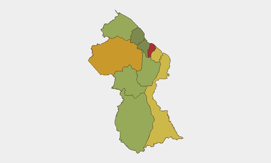
Demerara-Mahaica (risk 78) and Cuyuni-Mazaruni (risk 72) drive the national risk profile, with Mahaica-Berbice, East Berbice-Corentyne, and Upper Demerara-Berbice following in the 58–65 range. Georgetown and coastal urban corridors (Demerara-Mahaica) experience the highest concentrations of street crime, gang activity, and law-enforcement incidents. Cuyuni-Mazaruni and Upper Demerara-Berbice, encompassing interior mining zones and borderlands, face resource-competition violence, weapon proliferation, and Venezuela-linked border volatility. Mahaica-Berbice and East Berbice-Corentyne show elevated risk tied to violent crime and arson incidents. Lower-risk regions (Essequibo Islands, Pomeroon-Supenaam, Potaro-Siparuni) remain secondary concerns but warrant monitoring for spillover effects.
How GeoBit Would Assist
Security teams operating in Guyana should prioritize AOI Monitoring & Early Warning for Demerara-Mahaica (Georgetown), interior mining zones (Cuyuni-Mazaruni, Upper Demerara-Berbice), and Venezuela border regions, with persistent alerting for weapons seizures, mining violence, and arson. OSINT Fusion (X/Twitter geolocation, local news feeds, GPF/GDF statements, and radio SIGINT) would consolidate fragmented local reporting and fill timestamp gaps. Entity extraction and sentiment analysis across political and business figures (President Ali, Nazar Mohamed, Opposition Leader Azruddin Mohamed) would track escalation risk in governance disputes affecting duty-of-care liability.
7-Day Outlook
No imminent national-level security crisis is evident, but fragmentation in incident reporting and lack of 48-hour clarity on the two Aug-3 arrest events leave short-term trajectory uncertain. Continued monitoring of interior mining zones for weapon loss, arson patterns in Berbice, and political tensions is warranted. Coastal crime and Venezuela border volatility are expected to remain steady-state drivers of risk through early August.
Highest-Risk Areas — Ranked
| # | State / Region | Risk |
|---|---|---|
| 1 | Demerara-Mahaica | 78 |
| 2 | Cuyuni-Mazaruni | 72 |
| 3 | Mahaica-Berbice | 65 |
| 4 | East Berbice-Corentyne | 62 |
| 5 | Upper Demerara-Berbice | 58 |
| 6 | Potaro-Siparuni | 48 |
| 7 | Barima-Waini | 45 |
| 8 | Upper Takutu-Upper Essequibo | 42 |
| 9 | Pomeroon-Supenaam | 38 |
| 10 | Essequibo Islands | 35 |
Sources
Previous Daily Briefs
A new Guyana brief is written every day — each with its own risk map and downloadable CSV. Here's the last week; use the calendar to go further back.
📅 Browse every day by calendar →
Highlighted days have a brief. Tap a day for that day's map & analysis, or “csv” for that day's dataset ($5).
Atlas — our AI intelligence desk — emails them this snapshot personally. Nothing else, no list.