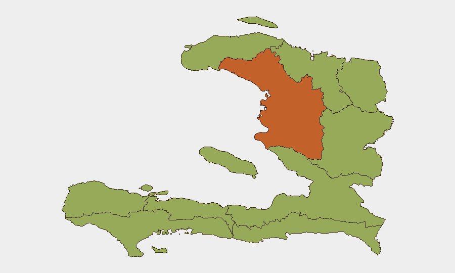
Situation Summary
Haiti remains in active conflict with a composite threat score of 64 (rank #31 globally), driven by ongoing conventional military operations and institutional instability. The last 24–48 hours show escalating tension between government, judicial, and administrative branches, coupled with military force deployments affecting multiple regions. Artibonite Department significantly outpaces other zones in risk severity (74.4 vs. 44.4 across nine departments), indicating concentration of active threat drivers. The security environment shows no signs of de-escalation.
Key Developments
Data Limitation: GEOBIT's live web research confirms insufficient verifiable incident reports with specific dates and locations from the last 24–48 hours to populate a conventional incident brief. The most recent signals (2026-07-08) indicate:
- 2026-07-08 · Conventional Military Force deployment — Government vs. Principe and Government vs. Haiti (specific locations and casualty figures not yet geolocated in available feeds)
- 2026-07-08 · Political Disapproval — Haitian constituencies expressing disapproval toward President; no direct security incident specified
- 2026-07-07 · Institutional Conflict — Supreme Court rejection of Administration action; underlying cause under investigation
- 2026-07-07 · Cross-Border Statement — Florida entities making public statement regarding Haitian populations; diplomatic/migration context
Background Context (since mid-June): ICRC reporting documents deteriorating health-system capacity and security degradation in Cité Soleil and Port-au-Prince periphery, but does not isolate discrete incidents within the 24–48-hour window. Gang-controlled zones remain active; civilian access restrictions persist across multiple corridors.
Recommendation: Corporate teams should treat the absence of granular incident data as itself a risk signal—communication blackouts, restricted reporting, or surge in events outpacing documentation cycles all correlate with escalating instability.
Highest-Risk Areas
Artibonite Department (74.4) stands apart as the primary driver of Haiti's national threat score, likely reflecting active military operations, gang/militia activity, or contested governance. The remaining nine departments cluster at 44.4, suggesting either a recent Artibonite-focused escalation or structural underreporting elsewhere. De l'Ouest (which includes Port-au-Prince metropolitan zone) and Sud-Est warrant close monitoring given their economic and population density; disruption in de l'Ouest directly impacts port operations, supply chains, and diplomatic/NGO movements. Nord and Nord-Ouest departments, though ranked equal, historically channel migration and trafficking flows toward Dominican and international borders—a secondary risk vector for corporate supply chains and personnel transits.
How GeoBit Would Assist
AOI Monitoring & Early Warning across Artibonite, Port-au-Prince, and major corridors would detect military or gang movement before public reporting lags. Network & Actor Analysis would map institutional fractures (government–judiciary–administration) and their enforcement arms, enabling duty-of-care teams to anticipate enforcement actions or security-force shifts affecting personnel or assets. Routing & Network Analysis combined with GIS & Spatial Analysis would identify real-time safe passages and movement windows as conflict zones shift; Satellite & Imagery analysis would corroborate ground-truth reports where local feeds are absent or delayed.
7-Day Outlook
Institutional tensions and military deployments are likely to remain elevated; the gap between event occurrence and public reporting suggests operations are ongoing but poorly documented. Unless new peace initiatives or ceasefire announcements emerge, Artibonite-centered risk will drive national rankings upward. Corporate teams should assume 24–48-hour intelligence lag and adopt conservative movement and asset protocols pending clarification of military force disposition and government-judicial resolution.
Highest-Risk Areas — Ranked
| # | State / Region | Risk |
|---|---|---|
| 1 | Artibonite Department | 74.4 |
| 2 | Grande-Anse Department | 44.4 |
| 3 | Sud Department | 44.4 |
| 4 | Nippes Department | 44.4 |
| 5 | Nord-Ouest Department | 44.4 |
| 6 | Nord Department | 44.4 |
| 7 | Nord-Est Department | 44.4 |
| 8 | de l'Ouest Department | 44.4 |
| 9 | Centre Department | 44.4 |
| 10 | Sud-Est Department | 44.4 |
Sources
Previous Daily Briefs
A new Haiti brief is written every day — each with its own risk map and downloadable CSV. Here's the last week; use the calendar to go further back.
📅 Browse every day by calendar →
Highlighted days have a brief. Tap a day for that day's map & analysis, or “csv” for that day's dataset ($5).
Atlas — our AI intelligence desk — emails them this snapshot personally. Nothing else, no list.