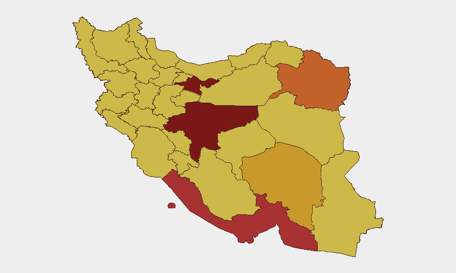
Situation Summary
Iran remains the second-highest composite threat globally, driven primarily by military strike activity and cross-border incidents. The last 48 hours reflect continued conventional military operations, public statements from multiple state actors, and at least one reported small-arms engagement (Jordan–Iran, 2026-06-13). Tehran Province and Isfahan Province remain critical risk nodes; infrastructure and personnel in these zones face elevated exposure to direct military action and secondary effects. The trajectory remains volatile with no clear de-escalation signal visible in available event data.
Key Developments
- 2026-06-13, Jordan–Iran border: Small arms combat reported; geographic specificity and casualty figures not yet confirmed in available feeds. Assess as potential precursor to broader cross-border friction.
- 2026-06-13, multiple public statements: Administration, presidential, and senatorial statements targeting Iran suggest heightened diplomatic and political pressure; timing and content warrant monitoring for signaling intent or policy shift.
- 2026-06-12, conventional military operations: Unspecified military force activity reported; location and scale not yet clarified in current signals. Correlate with NORAD/regional air-defense reports for scope assessment.
- 2026-06-12, shipping/sanctions: Administrative action targeting Iranian tanker vessel(s) signals continued economic pressure and maritime interdiction risk; affects any organization with supply-chain dependencies on Iranian or Iran-linked shipping.
- 2026-06-14, civil unrest: Demonstrator disapproval event recorded; location, scale, and driver (economic, political, or security-related) require clarification to assess local instability risk in affected province.
- 2026-06-12, threat communication: Iranian actor threat against Central African entity; assess as secondary spillover risk or regional proxy-activity indicator rather than direct Iran-domestic threat.
*Note: Precise locations, casualty figures, and operational scope for military events remain unconfirmed. Escalation assessment pending sub-state actor response and official statements.*
Highest-Risk Areas
Tehran Province (risk 100) and Isfahan Province (risk 99.3) dominate the risk landscape, reflecting proximity to critical national infrastructure, government decision-making centers, and documented military concentrations. Hormozgan and Bushehr Provinces (77.2 and 76.3 respectively) face elevated risk due to maritime exposure and strategic energy infrastructure; any naval escalation or targeting of port/refinery assets would cascade into both provinces. The tier-3 cluster (Razavi Khorasan, Kerman, Kohgiluye and Buyer Ahmad, East Azerbaijan, Golestan, Fars, Kurdistan) all score 70.2–73.0, indicating widespread baseline instability driven by cross-border activity, sectarian tensions, and proximity to conflict zones in Iraq and Syria. Organizations with operations or supply chains in the top five provinces should assume heightened risk of direct strike, infrastructure disruption, and civil unrest.
How GeoBit Would Assist
GeoBit's AOI Monitoring & Early Warning capability—persistent, rule-based watch on Tehran and Isfahan Provinces with automated alerting on military movement, air-defense radar activation, and protest/civil unrest clustering—provides real-time escalation signals ahead of mainstream news. Satellite & Imagery analysis corroborates military event claims and tracks damage/force posture changes at key bases and ports. Network & Actor Analysis linked to Intel Sweep (Telegram, X, and Farsi-language OSINT) identifies emerging cross-border actor communications and state signaling, enabling duty-of-care teams to move personnel or assets before public escalation.
7-Day Outlook
Military-to-military contact and political rhetoric remain elevated; no ceasefire or de-escalation framework is visible. Risk of further cross-border incidents or renewed strikes on Iranian military/energy infrastructure remains material over the next 7 days. Organizations should expect continued volatility in northern Persian Gulf maritime operations and heightened scrutiny on all Iran-linked financial and logistics flows.
Highest-Risk Areas — Ranked
| # | State / Region | Risk |
|---|---|---|
| 1 | Tehran Province | 100 |
| 2 | Isfahan Province | 99.3 |
| 3 | Hormozgan Province | 77.2 |
| 4 | Bushehr Province | 76.3 |
| 5 | Razavi Khorasan | 73 |
| 6 | Kerman Province | 71.3 |
| 7 | Kohgiluye and Buyer Ahmad Province | 70.6 |
| 8 | East Azerbaijan Province | 70.6 |
| 9 | Golestan Province | 70.6 |
| 10 | Fars Province | 70.4 |
| 11 | Kurdistan Province | 70.3 |
| 12 | Semnan Province | 70.2 |
Sources
Previous Daily Briefs
A new Iran brief is written every day — each with its own risk map and downloadable CSV. Here's the last week; use the calendar to go further back.
📅 Browse every day by calendar →
Highlighted days have a brief. Tap a day for that day's map & analysis, or “csv” for that day's dataset ($5).