Situation Summary
Iraq's security environment has markedly deteriorated over the past 48 hours, driven by a concurrent spike in armed clashes, aerial weapons deployment, assassination plots, and high-level diplomatic activity. Al-Anbar Governorate remains the primary locus of violence, with elevated activity also reported across northern Iraq and the Kurdistan Region. The U.S. Embassy has reinforced its Level 4 "Do Not Travel" advisory, and credible reporting indicates potential coordination among Iranian-backed militia elements in response to recent strikes. Overall trajectory is toward sustained elevated tension through at least mid-week.
Key Developments
- Kirkuk Governorate (June 15): Airstrikes near Kirkuk killed three PMF fighters and two Iraqi police officers in what reporting links to broader regional escalation and U.S.-ordered evacuation posture from parts of northern Iraq.
- Nationwide (June 14–15): Iraq's National Security Service arrested 15 individuals accused of plotting assassinations against senior security officials across multiple locations; concurrent threat reporting indicates a wider uptick in targeted-killing activity and risk.
- Baghdad (June 14–15): U.S. Embassy reiterated Level 4 "Do Not Travel" advisory, explicitly urging U.S. citizens to leave Iraq immediately due to escalating regional tensions and elevated risk to diplomatic and Western targets.
- Baghdad (past 48 hours): Open-source reporting from former Iraqi officials indicates a visit by IRGC Quds Force commander Ismail Qaani, with meetings held on militia operations and responses to recent strikes; implications for armed group coordination and U.S./coalition force security.
- Erbil (June 15): Kurdistan Region Prime Minister Masrour Barzani met the British Ambassador to discuss recent security developments, cross-border tensions, and risk of wider regional escalation affecting Iraq and the Kurdistan Region.
- Countrywide (June 14–15): A marked spike in threat reporting across 48 hours involving aerial weapons, small-arms combat, and conventional military force in provinces with significant militia and security-force presence; overall travel risk levels assessed as markedly elevated.
- Baghdad–Erbil (June 14–15): Heightened diplomatic traffic and high-profile engagement focused on stabilizing Erbil–Baghdad relations and coordinating regional security responses, reflecting concern over short-term political stability and conflict-spillover risk.
Highest-Risk Areas
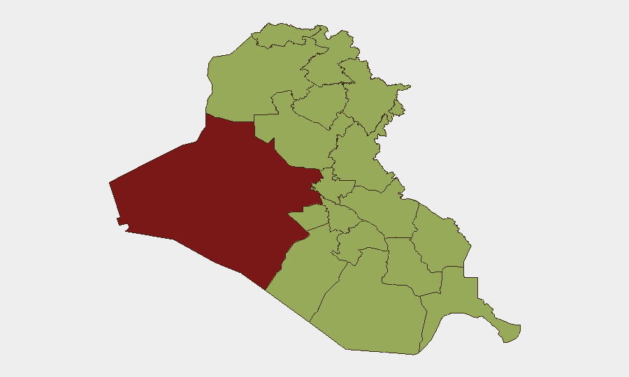
Al-Anbar Governorate (81.6) dominates the risk landscape, driven by ongoing militia activity, weapons trafficking, and militant presence that persist despite degradation of ISIS-affiliate cells. The concentration of PMF and Iraqi security forces in northern Iraq—particularly Kirkuk, Saladin, and Erbil—creates friction points where armed clashes, airstrikes, and assassination activity cluster. Southern governorates (Basra, Dhi Qar, Maysan) carry elevated but more diffuse risk related to militia competition and port/border security; the near-parity of scores across most regions (51.6) suggests generalized instability rather than localized hotspots, with significant secondary risk in Babil and Wasit along transport corridors.
How GeoBit Would Assist
Corporate security teams should activate AOI Monitoring & Early Warning on Al-Anbar, Kirkuk, and Baghdad to track real-time incident clusters and militia movement. OSINT Fusion & Corroboration (X, Telegram, open-source militia channels) combined with Network & Actor Analysis will clarify Iranian-backed coordination signaled by recent diplomatic activity. Routing & Network Analysis provides alternative movement corridors for staff and convoys, while Risk & Threat Assessment synthesizes aerial, small-arms, and assassination signals to refine duty-of-care posture and evacuation triggers.
7-Day Outlook
Sustained elevated threat environment through at least June 20, with highest risk in Al-Anbar, Kirkuk, and Baghdad. Militia response to recent strikes and ongoing coordination with Iranian elements suggest further clashes likely; assassination plots and security-force targeting will remain persistent. Any escalation in U.S. or allied operations could rapidly shift risk trajectory; de-escalatory diplomatic signals remain limited.
Highest-Risk Areas — Ranked
| # | State / Region | Risk |
|---|---|---|
| 1 | Al-Anbar Governorate | 81.6 |
| 2 | Al-Muthanna Governorate | 52 |
| 3 | Babil Governorate | 51.6 |
| 4 | Wasit Governorate | 51.6 |
| 5 | Al-Qadisiyah Governorate | 51.6 |
| 6 | Dhi Qar Governorate | 51.6 |
| 7 | Maysan Governorate | 51.6 |
| 8 | Al-Basra Governorate | 51.6 |
| 9 | Al-Najaf Governorate | 51.6 |
| 10 | Saladin Governorate | 51.6 |
| 11 | Erbil Governorate | 51.6 |
| 12 | Kirkuk Governorate | 51.6 |
Sources
Previous Daily Briefs
A new Iraq brief is written every day — each with its own risk map and downloadable CSV. Here's the last week; use the calendar to go further back.
📅 Browse every day by calendar →
Highlighted days have a brief. Tap a day for that day's map & analysis, or “csv” for that day's dataset ($5).