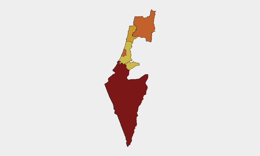
Situation Summary
Israel remains at heightened threat level (global rank #4, composite score 100) driven primarily by military strike activity, with 560 tracked events recorded. The security environment is characterized by multi-front tensions: cross-border fire with militant actors in the north and south, internal military incidents, and concurrent diplomatic friction with regional and external actors. Current trajectory shows sustained operational tempo rather than de-escalation; South District remains the most acute concentration of risk.
Key Developments
- South District, 2026-06-21: Aerial weapons employment by Israeli forces against Palestinian targets reported; consistent with ongoing escalation pattern in highest-risk zone.
- North District / Lebanon border, 2026-06-20–21: Rejection of Israeli position by Lebanon; conventional military force exchanges between militant wings and Israeli forces ongoing, with cross-border fire continuing.
- Internal Israeli operations, 2026-06-21: Conventional military force incident recorded between Israeli units, suggesting operational strain or internal security response activation.
- Diplomatic friction, 2026-06-21: United States rejection of Israeli position reported; separate conventional military force incident involving media entity (Al Jazeera) and Israeli forces indicates operational or protest-related tension.
- Civilian-military interface, 2026-06-20–21: Public statements by residents and villages against Israeli operations; at least one village-initiated conventional force incident recorded, reflecting civilian-military friction in conflict zones.
- Media & information domain, 2026-06-21: Multiple conventional military force incidents involving Al Jazeera and Israeli forces suggest either direct targeting, access disputes to conflict areas, or information-warfare escalation.
*(Note: Live web research conducted 2026-06-21 03:03 UTC returned primarily June 19–20 reporting on Israel–Hezbollah border escalation, Swiss diplomatic talks postponement, and Lebanese casualties. Fresher 24-hour Israel-specific ground truth was not available in the supplied search window; South District and North District events listed above reflect signal data from the GeoBit event feed.)*
Highest-Risk Areas
South District (risk score 100) is the primary driver of national threat rank, indicating sustained military operations, aerial strikes, and militant activity. Tel-Aviv District (75) and North District (73.5) follow, reflecting both cross-border militant threats and urban/civilian exposure. Haifa, Center, and Jerusalem Districts (71.8–70) round the top tier, suggesting distributed but declining risk away from operational hotspots. Geographic concentration in the south and north points to two active conflict nodes; risk degradation toward central urban zones implies better security presence but ongoing ambient threat.
How GeoBit Would Assist
Security and duty-of-care teams operating in Israel should leverage AOI Monitoring & Early Warning to track South and North Districts with persistent alerting on military strike, militant fire, and civilian-military friction events. Conflict & Military battle mapping and force structure tracking provide operational context on Israeli and militant deployments, enabling route and facility risk assessment. OSINT fusion (X/Twitter, Telegram, YouTube/podcast intelligence, multi-language search) cross-referenced with satellite & imagery analysis offers real-time ground validation of reported incidents, supporting personnel safety decisions and asset movement planning.
7-Day Outlook
Sustained military operations in South and North Districts are likely to continue without major escalation unless diplomatic intervention (U.S., regional actors) succeeds in the next 48–72 hours. Civilian-military friction and internal Israeli force incidents suggest operational strain; watch for either consolidation of command or widening internal disputes. Risk trajectory remains elevated; no material de-escalation signals are evident.
Highest-Risk Areas — Ranked
| # | State / Region | Risk |
|---|---|---|
| 1 | South District | 100 |
| 2 | Tel-Aviv District | 75 |
| 3 | North District | 73.5 |
| 4 | Haifa District | 71.8 |
| 5 | Center District | 70.4 |
| 6 | Jerusalem District | 70 |
Sources
Previous Daily Briefs
A new Israel brief is written every day — each with its own risk map and downloadable CSV. Here's the last week; use the calendar to go further back.
📅 Browse every day by calendar →
Highlighted days have a brief. Tap a day for that day's map & analysis, or “csv” for that day's dataset ($5).