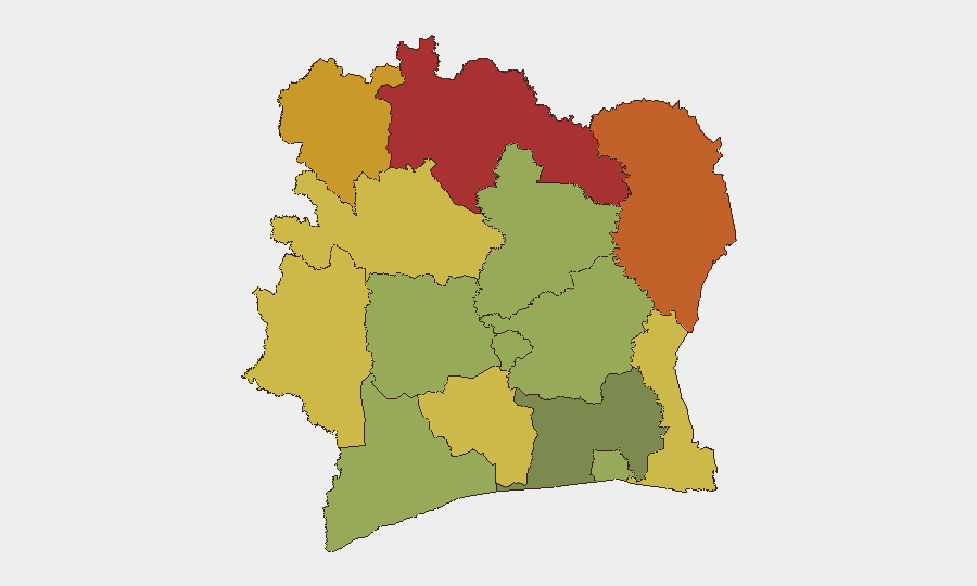
Situation Summary
Ivory Coast remains at comparatively low national threat level (rank #93 globally, composite score 11) with no tracked discrete security incidents in the current 24–48-hour window. Underlying structural vulnerabilities—including seasonal flood risk (59+ deaths since May) and persistent insecurity in northern frontier districts—remain endemic but stable. The country's security posture reflects post-2020 political consolidation and continued Sahel spillover dynamics affecting border regions rather than systemic national instability.
Key Developments
No reliably confirmed security or incident-level events meeting 24–48-hour verification criteria were identified in current open-source, news, and social-media channels.
Context & Longer-Term Signals:
- Flood impact (May–present, not new): Heavy seasonal rainfall has driven at least 59 confirmed deaths and infrastructure disruption nationwide; flood-prone areas remain at elevated risk through wet season.
- Northern border regions (ongoing): Savanes, Zanzan, and Denguélé districts continue to experience cross-border militant and bandit activity originating in Mali and Burkina Faso, consistent with Sahel regional trends; no new attack or mass-casualty event reported in 48h.
- Abidjan economic activity (current): African Space Solutions Market (July 2026) reflects normal capital-city operations and international business engagement.
Highest-Risk Areas
Northern frontier districts—Savanes (risk 78), Zanzan (75), and Denguélé (72)—dominate the sub-national risk profile. These regions share porous borders with Mali and Burkina Faso, where non-state armed groups and militant factions operate with intermittent cross-border incursions, banditry, and kidnapping-for-ransom activity. Comoé and Montagnes districts (risk 70 and 68 respectively) extend this risk corridor eastward and inland. By contrast, Abidjan and urban coastal areas (risk 45 and below) remain substantially lower-risk, reflecting state security presence and economic concentration. Risk in the north is chronic rather than acute and reflects regional Sahel instability rather than localized Ivorian state failure.
How GeoBit Would Assist
Security and risk teams with personnel or assets in Ivory Coast should deploy AOI Monitoring & Early Warning on Savanes, Zanzan, and Denguélé districts to detect upticks in militant activity, bandit movement, or cross-border incursions before they affect company operations or supply routes. Conflict & Military intelligence and Network & Actor Analysis enable tracking of key non-state groups operating in the north and their leadership, operational tempo, and targeting patterns. Routing & Network Analysis supports alternative journey planning for staff movement in or transiting high-risk districts, particularly during wet season when infrastructure is compromised.
7-Day Outlook
No acute escalation is anticipated over the next seven days. Continued seasonal flooding and minor cross-border bandit activity in the north remain the primary operational constraints; state security capacity and international Sahel stabilization efforts appear sufficient to prevent major spillover into populated southern areas. Risk teams should maintain routine vigilance on border zones and infrastructure-dependent logistics while monitoring wet-season impacts on road access.
Highest-Risk Areas — Ranked
| # | State / Region | Risk |
|---|---|---|
| 1 | Savanes District | 78 |
| 2 | Zanzan District | 75 |
| 3 | Denguélé District | 72 |
| 4 | Comoé District | 70 |
| 5 | Montagnes District | 68 |
| 6 | Woroba District | 65 |
| 7 | Gôh-Djiboua District | 60 |
| 8 | Sassandra-Marahoué District | 58 |
| 9 | Vallée du Bandama District | 55 |
| 10 | Bas-Sassandra District | 52 |
| 11 | Lacs District | 48 |
| 12 | Abidjan | 45 |
Sources
Previous Daily Briefs
A new Ivory Coast brief is written every day — each with its own risk map and downloadable CSV. Here's the last week; use the calendar to go further back.
📅 Browse every day by calendar →
Highlighted days have a brief. Tap a day for that day's map & analysis, or “csv” for that day's dataset ($5).
Atlas — our AI intelligence desk — emails them this snapshot personally. Nothing else, no list.