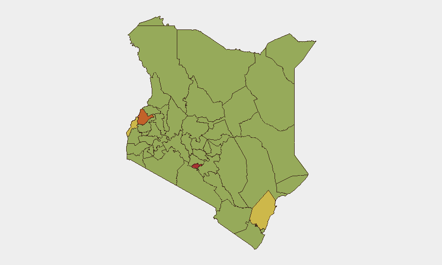
Situation Summary
Kenya remains at moderate-to-elevated composite threat (rank #25 globally, score 67) with concentrated volatility in border regions and the capital. The last 48 hours have seen coordinated al-Shabaab attack attempts in Mandera County, infrastructure targeting in Garissa, and ongoing regulatory enforcement in Nairobi—signaling persistent terrorist activity in the northeast alongside routine governance actions. Trajectory remains volatile in northeastern border zones; Nairobi County shows high operational risk tied to political tensions and law-enforcement activity rather than direct militant threat.
Key Developments
- Mandera County (Fino/Arabia/Asharaf border belt), evening 07-24-2026: Suspected al-Shabaab militants launched coordinated attacks on Fino security camp and surrounding areas; Kenyan security forces repelled the assault with heavy gunfire. One student was shot in the stomach and evacuated to hospital in stable condition; area clearance operations ongoing.
- Garissa County (Abakaile Village, Dadaab), night of 07-24/25-2026: Suspected al-Shabaab gunmen attacked a Safaricom telecommunications mast at approximately 20:00 local time, opening fire before departing. Mast sustained damage; no injuries reported. Assessed as attempt to disrupt communications infrastructure in border region.
- Nairobi & Kajiado counties, week concluding 07-25-2026: Pharmacy and Poisons Board enforcement operation arrested 95 individuals and shuttered 48 unlicensed pharmaceutical outlets suspected of distributing unregulated or counterfeit medicines. Represents significant regulatory enforcement with secondary impact on business operations and medication supply chains.
- Northeastern border zone (Mandera, Wajir, Garissa, Lamu), updated 07-25/26-2026: Foreign travel advisories reiterate "avoid all travel" to Somalia-bordering counties following recent militant activity. Advisories cite persistent risks of terrorist attack, kidnapping, and armed assault by Somalia-based groups.
- Laikipia County (isolation facility), ongoing through 07-25-2026: Seven American humanitarian workers quarantined under 21-day observation following DRC Ebola exposure; entry to Kenya circa 07-13-2026. No symptoms reported; quarantine framed as precautionary. Domestic debate over biosecurity compliance ongoing.
- National political/judicial tension, 07-24/25-2026: High Court disapproval statements directed at government; Nairobi officials expressing disapproval of national government; party leader public statement challenging government position. Indicates elevated political friction without direct security incident.
Highest-Risk Areas
Nairobi County (risk 77) leads sub-national rankings, driven by political tensions, law-enforcement activity, and concentration of high-value targets and critical infrastructure. Bungoma (73.9) and Busia (66) in the western corridor reflect cross-border crime and armed-group activity; Kilifi (66) and coastal Lamu (48.6) combine tourism infrastructure vulnerability with persistent al-Shabaab reach from Somalia. Northeast counties (Mandera, Garissa, Wajir)—though not in top 12 by composite score—remain the highest operational-threat zone due to direct militant presence and repeated attack cycles over the past 48 hours.
How GeoBit Would Assist
Security teams monitoring Kenya would employ AOI Monitoring & Early Warning for persistent watch on Nairobi County and northeastern border zones with real-time alerting on militant movement or political escalation. OSINT Fusion & Corroboration (X/Telegram/YouTube intelligence, multi-language search, entity extraction) accelerates verification of attack claims and political statements. Routing & Network Analysis supports duty-of-care teams in planning safer transit corridors away from Mandera/Garissa/Wajir, while Conflict & Military tracking maps al-Shabaab operational tempo and force disposition.
7-Day Outlook
Al-Shabaab attack cycles in the northeast are likely to persist or intensify during the dry season, with communications infrastructure and security installations remaining high-value targets. Political friction in Nairobi may escalate rhetorical conflict but is unlikely to trigger immediate civil unrest; regulatory enforcement operations will continue. Travel restrictions to Somalia-bordering counties remain in effect and should be assumed stable over the next week.
Highest-Risk Areas — Ranked
| # | State / Region | Risk |
|---|---|---|
| 1 | Nairobi County | 77 |
| 2 | Bungoma County | 73.9 |
| 3 | Busia County | 66 |
| 4 | Kilifi County | 66 |
| 5 | Taita–Taveta | 56.5 |
| 6 | Murang'a County | 53.4 |
| 7 | Migori County | 51.8 |
| 8 | Makueni | 51.8 |
| 9 | Vihiga County | 50.2 |
| 10 | Nakuru | 50.2 |
| 11 | Embu | 48.6 |
| 12 | Lamu | 48.6 |
Sources
Previous Daily Briefs
A new Kenya brief is written every day — each with its own risk map and downloadable CSV. Here's the last week; use the calendar to go further back.
📅 Browse every day by calendar →
Highlighted days have a brief. Tap a day for that day's map & analysis, or “csv” for that day's dataset ($5).
Atlas — our AI intelligence desk — emails them this snapshot personally. Nothing else, no list.