Situation Summary
Latvia remains a low-threat nation globally (rank #127), but experienced a significant airspace incursion on 14 August when NATO fighters shot down a foreign unmanned aerial vehicle over eastern territory near Lake Boževa. The incident triggered temporary airspace warnings across multiple eastern and southern regions and prompted the President to cut short his vacation, signaling elevated national concern. No casualties or property damage resulted, but the event underscores Latvia's exposure to cross-border spillover risk from ongoing regional military activity.
Key Developments
- Balvi Municipality, Lake Boževa area (14 August, ~04:50 local time): NATO-operated Italian Eurofighter and Turkish F-16 aircraft intercepted and destroyed a foreign unmanned aerial vehicle that had entered Latvian airspace. The drone was downed over a wooded area approximately 5 km from Rūga; no casualties or structural damage reported.
- Eastern and southern Latvia airspace (13–14 August, overnight into morning): Latvia's National Armed Forces issued formal airspace threat warnings covering Augšdaugava, Preiļi, Rēzekne, Balvi, and Alūksne regions. Residents received emergency alert messages; warnings were lifted at 04:50 on 14 August once NATO confirmed the threat had ended.
- Drone attribution and origin (14–15 August): Official investigations confirm the drone's origin as "unknown," but regional analysts and Reuters reporting link the intrusion to Ukrainian strike operations diverted off-course by Russian electronic warfare in the Baltic region. No confirmed attribution to a state actor has been released by Latvian authorities.
- Presidential response (14–15 August): President Edgars Rinkēvičs cancelled vacation plans and announced a national address scheduled for 15 August to brief residents on the heightened security situation, indicating governmental concern about public confidence and information management.
- Regional security narrative (14–15 August): Baltic and Finnish border officials reported the Latvia incident as part of a broader pattern of drone incursions affecting NATO's eastern flank, raising public and operational awareness of temporary airspace closures and military activity in border zones.
- Information-space volatility (15 August): Lithuanian and regional commentary introduced false-flag attribution concerns, though basic facts of the incident remain unchallenged. This adds uncertainty to public risk perception without changing immediate physical threat assessment.
Highest-Risk Areas
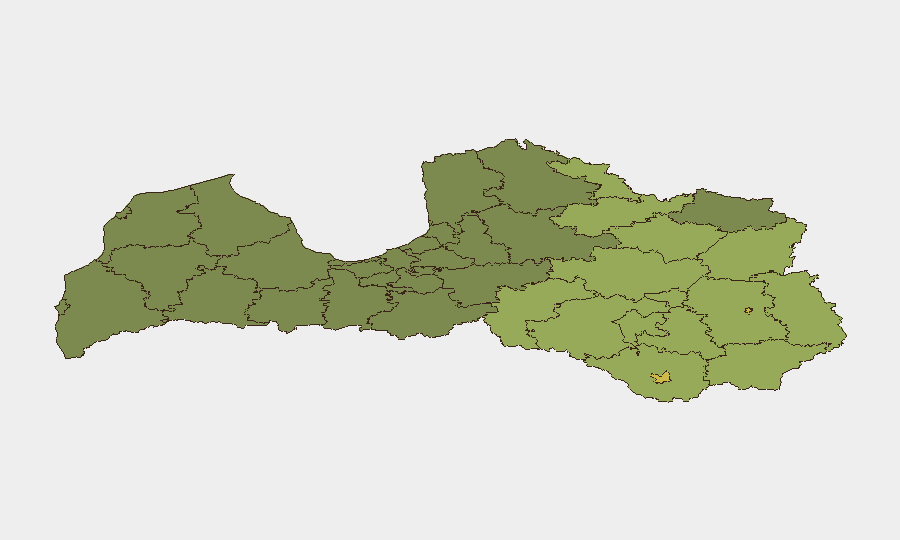
Rēzekne (risk 68) and Daugavpils (risk 65) rank as Latvia's highest-risk sub-national zones, with secondary clusters in Rēzeknes novads (58), Ludzas novads (55), and Balvu novads (52)—all located in eastern and southeastern Latvia near the Russian border. The 14 August drone incident directly validates this geographic pattern: the intercept zone near Lake Boževa falls within the Balvi high-risk corridor. Proximity to the border, exposure to regional military activity, and ongoing electronic warfare operations appear to be primary drivers of sub-national risk concentration in the east.
How GeoBit Would Assist
Security teams protecting assets or personnel in Latvia should employ AOI Monitoring & Early Warning capabilities to track airspace and military activity in Rēzekne, Daugavpils, and border regions in near real-time. OSINT fusion and multi-language event feeds would enable rapid cross-corroboration of incidents like the 14 August drone shoot-down and reduce exposure to false attribution claims. Aviation tracking and GIS spatial analysis support alternative route planning for critical personnel movements and supply chains operating in or transiting eastern Latvia during periods of elevated military activity.
7-Day Outlook
Short-term risk remains elevated in eastern Latvia due to ongoing regional tensions, persistent Russian electronic warfare operations, and NATO's sustained air policing presence. Airspace warnings and military interceptions are likely to recur with little notice. No significant escalation beyond the current pattern is forecast, but corporate teams should maintain flexible contingency protocols for temporary airspace closures and brief travel delays in border regions over the next 7 days.
Highest-Risk Areas — Ranked
| # | State / Region | Risk |
|---|---|---|
| 1 | Rēzekne | 68 |
| 2 | Daugavpils | 65 |
| 3 | Rēzeknes novads | 58 |
| 4 | Ludzas novads | 55 |
| 5 | Balvu novads | 52 |
| 6 | Preiļu novads | 50 |
| 7 | Krāslavas novads | 48 |
| 8 | Jēkabpils novads | 47 |
| 9 | Augšdaugavas novads | 46 |
| 10 | Aizkraukles novads | 45 |
| 11 | Varakļānu novads | 44 |
| 12 | Līvānu novads | 43 |
Sources
Previous Daily Briefs
A new Latvia brief is written every day — each with its own risk map and downloadable CSV. Here's the last week; use the calendar to go further back.
- August 13, 2026
- August 11, 2026
- August 9, 2026
- August 8, 2026
- August 6, 2026
- August 5, 2026
- August 4, 2026
📅 Browse every day by calendar →
Highlighted days have a brief. Tap a day for that day's map & analysis, or “csv” for that day's dataset ($5).
Atlas — our AI intelligence desk — emails them this snapshot personally. Nothing else, no list.