Situation Summary
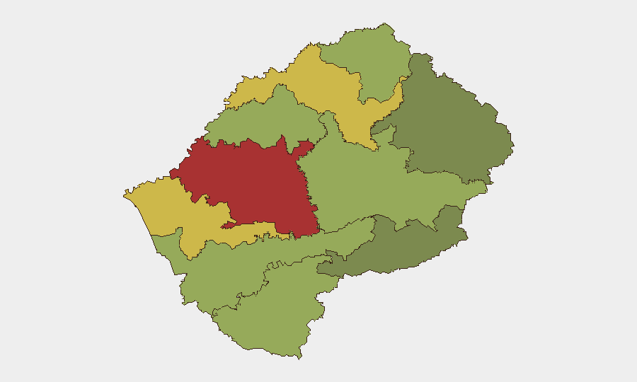
Lesotho remains a low-priority global security concern (composite threat score 4; no tracked discrete events in the current window). Sub-national risk is concentrated in the capital and surrounding districts, with Maseru District significantly outranking other regions. No active security incidents, unrest, or infrastructure disruptions have been reported in the last 24–48 hours.
Key Developments
No discrete security, crime, unrest, or infrastructure events have been identified in Lesotho in the last 24–48 hours. Verification of recent developments was not possible due to absence of reliable, timestamped reporting in the current search window.
Action for teams: If specific incidents, protests, or travel disruptions have occurred locally, submission of verified reports will enable immediate cross-referencing and risk assessment.
Highest-Risk Areas
Risk is heavily weighted toward Maseru District (score 78), which hosts the capital and concentrates economic, political, and security-sector activity. Secondary concern attaches to Mafeteng (65) and Leribe (62) districts, likely reflecting higher population density and historical patterns of organized crime and civil unrest. Rural and border districts (Qacha's Nek, Mokhotlong) carry significantly lower risk profiles, suggesting threat concentration in urban and peri-urban zones. Teams operating outside Maseru should maintain baseline situational awareness but face substantially lower exposure than those in the capital.
How GeoBit Would Assist
For ongoing Lesotho coverage, security teams should deploy AOI Monitoring & Early Warning on Maseru District and other high-risk zones to capture emerging unrest, crime incidents, or infrastructure disruptions in real time. Intel Sweep (event feeds, OSINT fusion, X/Telegram intelligence) would provide 24–48 hour detection of political instability, strikes, or security-force activity. For duty-of-care purposes, Routing & Network Analysis enables identification of safe transit corridors and alternative travel plans in the event of localized disruption; combined with GIS & Spatial Analysis, this supports dynamic personnel positioning and incident response.
7-Day Outlook
No imminent security escalation is indicated. Maseru District will remain the primary focus for routine corporate security monitoring; teams should confirm local contact networks and evacuation routes as standard practice. Further guidance will be issued if verified events emerge.
RECOMMENDATION: Submit any verified Lesotho incidents, civil unrest, or travel disruptions from the last 48 hours for immediate intelligence integration and risk update. GeoBit can also execute targeted multi-language search and X/Telegram OSINT on request to surface recent developments if keyword specificity is provided.
Highest-Risk Areas — Ranked
| # | State / Region | Risk |
|---|---|---|
| 1 | Maseru District | 78 |
| 2 | Mafeteng District | 65 |
| 3 | Leribe District | 62 |
| 4 | Berea District | 58 |
| 5 | Mohale's Hoek District | 52 |
| 6 | Butha-Buthe District | 48 |
| 7 | Thaba-Tseka District | 45 |
| 8 | Quthing District | 42 |
| 9 | Mokhotlong District | 38 |
| 10 | Qacha's Nek District | 28 |
Previous Daily Briefs
A new Lesotho brief is written every day — each with its own risk map and downloadable CSV. Here's the last week; use the calendar to go further back.
📅 Browse every day by calendar →
Highlighted days have a brief. Tap a day for that day's map & analysis, or “csv” for that day's dataset ($5).
Atlas — our AI intelligence desk — emails them this snapshot personally. Nothing else, no list.