Situation Summary
Liberia remains broadly stable at the national level, with no large-scale armed conflict, infrastructure sabotage, or mass civil unrest reported in the last 24–48 hours. However, localized civil tensions in Monrovia—driven by land disputes, protest activity, and political friction—have created short-term security friction points requiring situational awareness. Security conditions outside the capital remain routine, though northern and southeastern counties continue to register elevated composite risk scores warranting standard precautionary monitoring.
Key Developments
- Monrovia, Battery Factory/Jamaica Road corridor, 18 July (morning): Police land-dispute enforcement operation triggered violent clashes with residents along Japan Freeway, resulting in at least one police officer injury, roadblocks, tire burning, stone-throwing, and multiple arrests; incident lasted several hours with heavy equipment damaged and sustained standoff reported.
- Monrovia, central district, 17 July: During "Lead or Leave" anti-government protest, organizers reported recovery of a firearm and ammunition from an unidentified individual; detainee was released by protest organizers, who retained the weapon and demanded government forensic investigation, linking the incident to broader concerns over illegal firearms ahead of the STAND protest.
- Monrovia, 17 July (STAND protest security posture): Liberia National Police deployed officers across strategic Monrovia locations in anticipation of possible unrest and reported prior interception of suspected improvised incendiary devices allegedly connected to the planned demonstration.
- Monrovia, 18 July (post-protest policing): Police declared protest leader Mulbah Morlu "wanted" over an allegedly stolen police firearm, surrounded his residence with a search warrant, and publicly accused him of possession; no mass unrest or armed escalation confirmed at time of reporting.
- **Monrovia, 18–20 July (political friction): Multiple signals indicating strained diplomatic relations and domestic political friction following protests and high-profile crime cases; no large-scale street violence or armed clashes confirmed as of 20 July.
Highest-Risk Areas
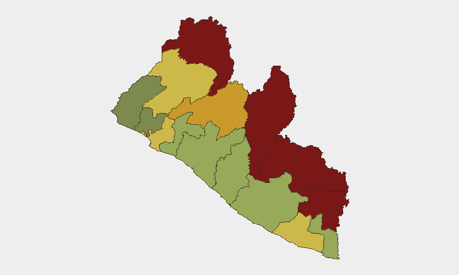
Nimba, Lofa, and Grand Gedeh counties drive the sub-national risk ranking (92, 88, and 85 respectively), reflecting a concentration of threat factors in Liberia's northern and southeastern borderlands. These areas historically experience cross-border smuggling, weapon movement, and lower state capacity; Bong and Gbarpolu counties similarly rank elevated (72 and 68), suggesting persistent vulnerabilities across the northern tier. Montserrado County (64)—which includes Monrovia—ranks eighth nationally but demands active day-to-day monitoring due to political volatility, population density, and concentration of critical infrastructure and expatriate presence. Southern coastal counties (Sinoe, Grand Bassa, Margibi) carry lower composite scores but should not be disregarded in asset-protection planning.
How GeoBit Would Assist
Security teams should deploy AOI (Area-of-Interest) Monitoring with alerting on Monrovia (particularly Battery Factory, Jamaica Road, and central protest zones) and on the five highest-risk northern counties to catch emerging clashes, checkpoint activity, or firearm trafficking in real time. OSINT fusion and multi-language search (Twitter, local broadcasters, Telegram) will surface early warning of planned protests, police operations, or inter-community disputes before they escalate. Routing and network analysis enables identification of safe transit corridors around active civil tension zones and provides duty-of-care teams with alternative journey planning during periods of localized unrest.
7-Day Outlook
Short-term risk remains contained to Monrovia's political and land-dispute tensions; no nationwide escalation is forecast. Monitor police wanted-person operations and post-protest political rhetoric for signs of broader state-opposition confrontation or armed group activity. Standard precautionary protocols should remain in place for expatriate personnel in the capital; routine operations are expected to resume elsewhere in the country.
Highest-Risk Areas — Ranked
| # | State / Region | Risk |
|---|---|---|
| 1 | Nimba County | 92 |
| 2 | Lofa County | 88 |
| 3 | Grand Gedeh County | 85 |
| 4 | River Gee County | 83 |
| 5 | Bong County | 72 |
| 6 | Gbarpolu County | 68 |
| 7 | Grand Kru County | 65 |
| 8 | Montserrado County | 64 |
| 9 | Rivercess County | 58 |
| 10 | Sinoe County | 55 |
| 11 | Margibi County | 52 |
| 12 | Grand Bassa County | 48 |
Sources
Previous Daily Briefs
A new Liberia brief is written every day — each with its own risk map and downloadable CSV. Here's the last week; use the calendar to go further back.
📅 Browse every day by calendar →
Highlighted days have a brief. Tap a day for that day's map & analysis, or “csv” for that day's dataset ($5).
Atlas — our AI intelligence desk — emails them this snapshot personally. Nothing else, no list.