Situation Summary
Lithuania remains a moderate-risk operating environment (global rank #121) with an active threat surface shaped by irregular migration pressure from Belarus, suspected Russian intelligence activity, and recent severe weather impacts. The past week has seen confirmed border-security incidents (tunnel discoveries), alleged GRU-linked arrests, and a significant windstorm affecting southern regions. Overall trajectory is stable but requires heightened awareness in border counties and Vilnius.
Key Developments
- Druskininkai Municipality / Lithuania–Belarus border, 12 Aug 2026 — Lithuanian border guards discovered an underground tunnel suspected of facilitating irregular migration from Belarus; this follows discovery of similar infrastructure in the same region in recent weeks and reflects sustained smuggling pressure on the border.
- National border fortifications, 12 Aug 2026 — Lithuanian government approved modifications to planned defensive engineering works along Belarus and Kaliningrad Oblast borders, including new defensive belts; decision follows sustained cross-border security incidents and intelligence assessments of irregular-migration and potential infiltration risk.
- Vilnius / National, 6 Aug 2026 — Lithuanian authorities charged 13 individuals in connection with alleged attempted-murder cases linked to Russian GRU networks; charges reflect an ongoing pattern of suspected Russian intelligence operations and associated violence within Lithuania's territory.
- Airspace, 6 Aug 2026 — Suspected smuggler balloons launched from Belarus triggered overnight airspace closure and operational halt; full restoration was completed by end of day, indicating rapid response capability but also persistent low-level cross-border incursion attempts.
- Southern Lithuania, 7 Aug 2026 — Severe windstorm caused structural damage and felled approximately 8,000 cubic metres of timber; power and transport infrastructure were disrupted, necessitating emergency-response activation and supply-chain contingency planning.
Highest-Risk Areas
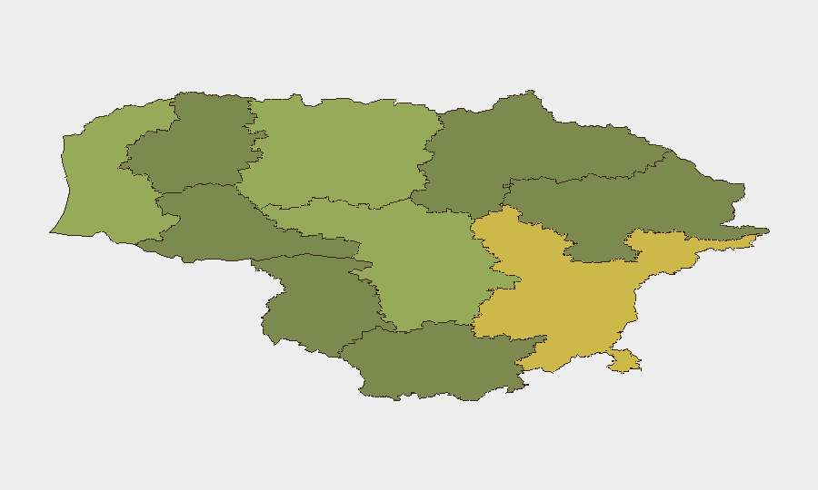
Vilnius County dominates the sub-national risk ranking (score 68) and accounts for capital-city concentration of government, diplomatic, finance, and media infrastructure—making it the primary target for intelligence operations and the location where the recent GRU-linked arrests occurred. Kaunas County (58) and Klaipeda County (52) follow, with Klaipeda's proximity to Kaliningrad Oblast and its role as a logistics hub elevating risk. The southern border counties (Taurage, Alytus, Marijampole) show lower absolute scores but are operationally critical chokepoints for irregular-migration and smuggling networks, and warrant continuous monitoring given recent tunnel discoveries.
How GeoBit Would Assist
Organisations with operations or personnel in Lithuania should deploy AOI Monitoring & Early Warning for Vilnius County and the Belarus border zone to track irregular-migration activity, smuggling infrastructure, and cross-border incursions in real time. Network & Actor Analysis combined with OSINT fusion (X/Twitter, Telegram, local media) will enable tracking of suspected Russian intelligence networks and associated criminal activity. GIS & Spatial Analysis with satellite and imagery capability supports assessment of border fortification changes and identification of new infiltration routes.
7-Day Outlook
Near-term risk trajectory remains elevated but not acute. Irregular-migration pressure and suspected Russian intelligence operations will persist through the remainder of August. Weather-related infrastructure impacts from the 7 August windstorm may create secondary vulnerabilities in transportation and power networks, requiring asset-protection contingency planning in affected southern regions.
Highest-Risk Areas — Ranked
| # | State / Region | Risk |
|---|---|---|
| 1 | Vilnius County | 68 |
| 2 | Kaunas County | 58 |
| 3 | Klaipeda County | 52 |
| 4 | Siauliai County | 42 |
| 5 | Panevezys County | 38 |
| 6 | Taurage County | 35 |
| 7 | Utena County | 33 |
| 8 | Alytus County | 32 |
| 9 | Telsiai County | 28 |
| 10 | Marijampole County | 25 |
Sources
Previous Daily Briefs
A new Lithuania brief is written every day — each with its own risk map and downloadable CSV. Here's the last week; use the calendar to go further back.
📅 Browse every day by calendar →
Highlighted days have a brief. Tap a day for that day's map & analysis, or “csv” for that day's dataset ($5).
Atlas — our AI intelligence desk — emails them this snapshot personally. Nothing else, no list.