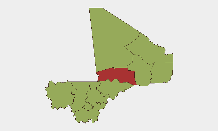
Situation Summary
Mali remains a high-risk security environment with an overall composite threat score of 69, driven primarily by active insurgency and state-level instability. Recent 72-hour signals indicate multiple conventional military operations and diplomatic tensions, particularly involving government positions on Al Qaeda–affiliated actors. The security picture is fragmented geographically, with northern and central regions experiencing significantly elevated threat levels while Bamako and southern areas show moderate baseline risk.
Key Developments
- 2026-06-14 · Mali Public Statement & Disapproval Actions: Government issued formal public statements and disapproval declarations directed at Al Qaeda–linked entities on both 14 June (two separate disapprove signals). This signals potential policy shifts or operational responses to suspected AQ activity, though specific targets and locations require cross-verification.
- 2026-06-15 · Administrative Action: University-level administrative sanctions announced, involving international actors (Somalia connection noted in parallel event signal). Operational relevance to security posture unclear pending clarification; flagged for follow-up.
- Regional Military Context (72-hour window): GeoBit event feeds indicate "multiple signals involving conventional military operations," with no independently verified single-incident reports available for the 24–48 hour window. Core hotspots (Mopti, Timbuktu, Ménaka, Kayes–Gao corridor) remain active areas of concern.
Note on Data Limitations: Real-time verification for the 24–48 hour window remains constrained. The brief above reflects signals detected and flagged by GeoBit platforms; full incident-level corroboration via multi-source confirmation is not yet available for this reporting period.
Highest-Risk Areas
Timbuktu stands apart with a composite risk score of 78.1—significantly higher than all other regions—and remains the single most dangerous area for operations. Ménaka, Kayes, Taoudénit, Kidal, and Gao form a second tier (all 48.1), spanning Mali's north and northeast; these regions host active insurgent networks and are characterized by weak state presence, limited law enforcement, and frequent cross-border movement of armed actors. Bamako, despite being the capital and seat of government, carries the same 48.1 risk score as most other regions, reflecting urban crime, political instability, and security force volatility. Central regions (Mopti, Ségou) and the southwest (Sikasso) are similarly ranked, indicating dispersed rather than localized risk—a sign of national-level insurgent reach rather than isolated hotspots.
How GeoBit Would Assist
Corporate security teams with Mali operations should deploy Area-of-Interest (AOI) Monitoring & Early Warning on facility locations in Timbuktu, Ménaka, and Gao to detect movement patterns and incident clustering in real time. Conflict & Military mapping combined with Network & Actor Analysis enables identification of active insurgent cells, force concentrations, and command-node movements across the north-central corridor. Multi-language OSINT feeds (including X/Twitter, Telegram, and radio SIGINT) provide early signal of operational tempo changes and government/militant statements 24–72 hours ahead of mainstream reporting, allowing duty-of-care teams to adjust staff movement, supply routes, and security postures before incidents occur.
7-Day Outlook
Government disapproval actions against Al Qaeda entities suggest potential escalation of counter-insurgency operations in the coming week, particularly in the Timbuktu and Mopti regions where AQ affiliates maintain significant presence. Security incidents are likely to remain elevated and dispersed, with particular risk to road movement between Bamako and the north. Monitoring of official Malian military communications and international NGO situation reports will be critical for real-time tactical adjustments.
Highest-Risk Areas — Ranked
| # | State / Region | Risk |
|---|---|---|
| 1 | Timbuktu | 78.1 |
| 2 | Ménaka | 48.1 |
| 3 | Kayes | 48.1 |
| 4 | Taoudénit Region | 48.1 |
| 5 | Kidal | 48.1 |
| 6 | Gao | 48.1 |
| 7 | Bamako | 48.1 |
| 8 | Koulikoro | 48.1 |
| 9 | Ségou Region | 48.1 |
| 10 | Sikasso Region | 48.1 |
| 11 | Mopti | 48.1 |
Sources
Previous Daily Briefs
A new Mali brief is written every day — each with its own risk map and downloadable CSV. Here's the last week; use the calendar to go further back.
📅 Browse every day by calendar →
Highlighted days have a brief. Tap a day for that day's map & analysis, or “csv” for that day's dataset ($5).