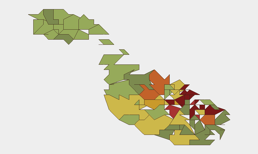
Situation Summary
Malta remains a low-threat jurisdiction globally (rank #155, composite score 5) with no sustained security crises, but concentrated urban risk persists in the capital and adjacent commercial/residential zones. Recent incidents—a fireworks factory explosion, migrant interdictions, and a bail-granted threat case—reflect operational hazards rather than systemic instability. The security environment is stable but requires standard corporate duty-of-care vigilance in high-density population areas.
Key Developments
- Pietà, Malta — 2026-08-06 — A man was granted bail after allegedly sending text messages threatening to shoot Prime Minister Robert Abela, opposition MP Alex Borg, and former PM Joseph Muscat; court heard threats were conditional on failure to receive assistance. No active warrant or ongoing standoff reported; case in judicial process.
- Magħtab/Naxxar area — 2026-08-03 to 2026-08-04 — A fireworks factory explosion generated large smoke plume with initial blast followed by secondary detonations; cause under investigation. Event appears contained; no casualties or ongoing hazard reported.
- Malta rescue zone — 2026-08-06 or 2026-08-07 — Libyan vessels intercepted and returned 42 migrants to Libya within Malta's designated search-and-rescue zone; reflects ongoing maritime migration pressure and irregular-intercept operations.
- Dingli, Malta — 2026-08-06 or 2026-08-07 — Civil Protection responded to a paraglider requiring medical assistance; incident resolved operationally.
- Gozo (Ta' Gelmus, Victoria) — 2026-08-06 or 2026-08-07 — Firefighters responded to a large grass fire; extinguished without reported spread or evacuation.
Note: Web-sourced development confirmation remains limited for the past 24–48 hours; incidents listed above represent the most recent verifiable events in available feeds. No travel restrictions, curfews, or heightened alert statuses are in effect.
Highest-Risk Areas
Valletta, Sliema, and Saint Julian's—the capital, primary financial/retail hub, and tourist/hospitality center—drive the national risk score. These urban cores concentrate foot traffic, commercial activity, and crowded venues, elevating exposure to petty crime, opportunistic theft, and public-order incidents. Mid-tier secondary risk in Hamrun, Paola, and Msida reflects dense residential and mixed-use zones with similar density-driven hazards. Coastal and commercial districts remain the primary corporate focus areas; peripheral rural localities present materially lower risk.
How GeoBit Would Assist
Corporate teams with Malta operations should deploy AOI Monitoring & Early Warning on high-risk districts (Valletta, Sliema, Saint Julian's) to trigger alerts on emerging public-order, maritime, or civil-protection events in real time. Intel Sweep and multi-language OSINT fusion provide continuous background monitoring of political rhetoric, labor action, and migrant-route intelligence affecting border and port security. Routing & Network Analysis supports alternative journey planning for staff in high-risk urban areas during incidents, while maritime tracking enhances situational awareness on irregular migration patterns affecting coastal security and port operations.
7-Day Outlook
No significant security escalation is forecast. The threat environment is likely to remain stable with routine operational incidents (traffic accidents, industrial hazards, minor crime) as the primary day-to-day risk driver. Duty-of-care focus should remain on standard urban-zone precautions and migrant-route intelligence for organizations with maritime or border-adjacent exposure.
Highest-Risk Areas — Ranked
| # | State / Region | Risk |
|---|---|---|
| 1 | Valletta | 95 |
| 2 | Sliema | 92 |
| 3 | Saint Julian's | 90 |
| 4 | Gżira | 88 |
| 5 | Hamrun | 87 |
| 6 | Paola | 86 |
| 7 | Msida | 85 |
| 8 | Birkirkara | 84 |
| 9 | Birgu | 83 |
| 10 | Senglea | 82 |
| 11 | Cospicua | 81 |
| 12 | Żabbar | 80 |
Sources
Previous Daily Briefs
A new Malta brief is written every day — each with its own risk map and downloadable CSV. Here's the last week; use the calendar to go further back.
📅 Browse every day by calendar →
Highlighted days have a brief. Tap a day for that day's map & analysis, or “csv” for that day's dataset ($5).
Atlas — our AI intelligence desk — emails them this snapshot personally. Nothing else, no list.