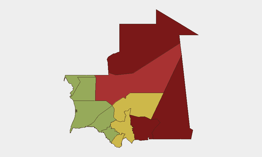
Situation Summary
Mauritania remains in a low-incident reporting window as of 4 August 2026, with no verified security, unrest, or crime incidents documented in open sources over the last 24–48 hours. The country's composite threat score of 7 reflects a baseline of manageable but persistent risks concentrated in the northern and eastern regions. The absence of discrete event reporting should not be interpreted as absence of risk; rather, it reflects a current gap in publicly available incident confirmation.
Key Developments
No verifiable security, unrest, crime, or travel-risk incidents in Mauritania have been confirmed by open-source reporting, national agency statements, or corroborated social-media signals within the last 24–48 hours (3–4 August 2026). GeoBit's live web research, multi-language OSINT feeds, and event-signal monitoring detected no incident-level events meeting recency and verification thresholds for this reporting window.
Background context (outside the 24–48h window, provided for operational awareness):
- Armed forces conducted live-fire exercises near Tweïla (Nouakchott–Akjoujt axis) on 29–30 July; civilian movement restrictions may remain in effect in that zone.
- Cyber-threat reporting for H1 2026 noted over 10,000 detected threats and 470 confirmed removals across the financial-services sector, though no discrete incident is attributed to the last 48 hours.
- Administrative actions against National Guard and other security-force personnel have been reported, but lack current timestamps.
Highest-Risk Areas
Tiris Zemmour (risk 95), Hodh Ech Chargui (85), and Hodh El Gharbi (80) account for the most acute composite risk, driven by remoteness, limited state capacity, cross-border criminal and militant activity, and historical unrest patterns. Adrar, Tagant, and Guidimaka extend this belt of elevated risk across the interior and eastern frontier regions. These areas experience chronic constraints on law enforcement, cross-border smuggling, and sporadic security-force operations; corporate personnel and supply chains in or near these zones warrant heightened monitoring and contingency planning. Southern and coastal regions (Brakna, Dakhlet Nouadhibou) present lower but non-negligible risk, principally linked to economic activity and maritime security.
How GeoBit Would Assist
Security teams with people or assets in Mauritania should employ AOI (Area-of-Interest) Monitoring & Early Warning on high-risk regions—particularly Tiris Zemmour and the Hodh zones—to detect emerging unrest, armed activity, or displacement signals with advance notice. Intel Sweep and multi-language OSINT (Arabic, French, and local sources) combined with social-media analysis (X, Telegram, local platforms) close the current reporting gap and provide real-time visibility on incidents, protests, or administrative actions affecting operations. Routing & Network Analysis should be used to identify and pre-position alternative supply and personnel-movement routes, especially around Nouakchott–Akjoujt and interior corridors, in case of security-force exercises or road closures.
7-Day Outlook
No imminent escalation is evident in current reporting; however, the lack of discrete incidents should not be mistaken for stability. Ongoing cross-border pressures, administrative changes within security forces, and seasonal patterns (drier months, increased bandit activity) warrant sustained monitoring. Teams should expect routine operations to continue with baseline risk in the north and east; any change in incident reporting frequency or type will signal a shift in the operational environment.
Highest-Risk Areas — Ranked
| # | State / Region | Risk |
|---|---|---|
| 1 | Tiris Zemmour | 95 |
| 2 | Hodh Ech Chargui | 85 |
| 3 | Hodh El Gharbi | 80 |
| 4 | Adrar | 78 |
| 5 | Tagant | 68 |
| 6 | Guidimaka | 65 |
| 7 | Assaba | 62 |
| 8 | Gorgol | 58 |
| 9 | Trarza | 55 |
| 10 | Inchiri | 52 |
| 11 | Brakna | 48 |
| 12 | Dakhlet Nouadhibou | 45 |
Sources
Previous Daily Briefs
A new Mauritania brief is written every day — each with its own risk map and downloadable CSV. Here's the last week; use the calendar to go further back.
📅 Browse every day by calendar →
Highlighted days have a brief. Tap a day for that day's map & analysis, or “csv” for that day's dataset ($5).
Atlas — our AI intelligence desk — emails them this snapshot personally. Nothing else, no list.