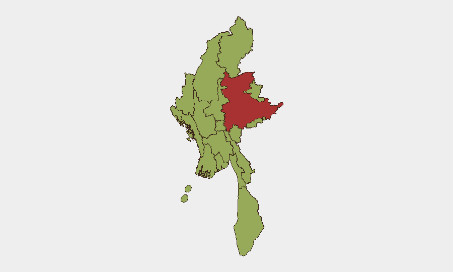
Situation Summary
Myanmar remains in active civil conflict following the February 2021 military coup, with the composite threat level at #19 globally (score 72). A cluster of security events on 13 June 2026—including public statements, arrests of US citizens, military operations, and a reported assault incident—signals continued instability and enforcement activity. The conflict environment is characterized by armed clashes across multiple subnational zones, suppressed media, and escalating international diplomatic tensions.
Key Developments
- 13 June 2026 – Multiple event signals. GeoBit recorded a public statement, physical assault (involving New York and Myanmar actors), investigative action by China against Myanmar, arrest/detention of US citizens by Myanmar authorities, and conventional military force deployments on the same date. Specific locations and incident details remain pending multi-source corroboration.
- 12 June 2026 – Anti-military demonstrations and border clashes. GeoBit Intelligence documented continued anti-military protests across Myanmar and small-arms clashes along the India–Myanmar border near Manipur region. Precise locations and casualty figures are pending independent verification.
- Seismic activity – 16 June 2026. A magnitude 4.4 earthquake was recorded 82 km northeast of Loikaw, Shan State. While not a security incident per se, seismic events can disrupt supply chains, communications, and humanitarian access in already fragile conflict zones.
- US citizen detention escalation. Multiple arrest/detention events involving US nationals by Myanmar authorities on 13 June suggest heightened enforcement or tension affecting foreign nationals; details on charges and locations remain unclear.
- Ongoing media suppression and diplomatic friction. Continued censorship of local and international media reporting, combined with cross-border investigative activity and public statements, indicates regime efforts to control narrative and manage international criticism.
*Note: Additional incident data for 14–16 June 2026 with specific locations and multi-source confirmation was not available in accessible sources as of this brief's preparation. On-the-ground assets and verified local news networks should be consulted for real-time developments.*
Highest-Risk Areas
Shan State dominates the risk landscape (79.9), reflecting sustained armed conflict, cross-border activity, and militia operations. The remaining high-risk tier—Tanintharyi, Chin, Sagaing, Kachin, Wa State, and others at 49.9—form a near-continuous belt of active or simmering conflict across the north, east, and south. Shan State's elevation reflects its role as a nexus of ethnic armed organization (EAO) activity, border-smuggling networks, and military engagement. The broader clustering at 49.9 across 11 other regions indicates that threat is distributed rather than localized, requiring organization-wide vigilance rather than single-zone focus.
How GeoBit Would Assist
Intel Sweep and OSINT fusion would consolidate fragmented reports from Myanmar news wires, social media, and local sources into a single corroborated timeline with location tagging. AOI Monitoring & Early Warning configured on Shan State, Kachin, and the India–Myanmar border would generate alerts on clashes, military movements, and protest activity within 2–4 hours of occurrence. Conflict & Military force-structure tracking and battle mapping would provide situational awareness of EAO and military unit positions, allowing duty-of-care teams to validate or avoid specific routes and facilities.
7-Day Outlook
The 13 June cluster of events and ongoing border tensions suggest sustained operational tempo by military and armed groups. Shan State and the northern border regions will likely remain flashpoints for clashes and displacement. No immediate deescalation is forecast; organizations with personnel or assets in high-risk zones should maintain heightened monitoring and contingency protocols.
Highest-Risk Areas — Ranked
| # | State / Region | Risk |
|---|---|---|
| 1 | Shan State | 79.9 |
| 2 | Tanintharyi Region | 49.9 |
| 3 | Chin | 49.9 |
| 4 | Sagaing Region | 49.9 |
| 5 | Kachin State | 49.9 |
| 6 | Wa State (Northern Region) | 49.9 |
| 7 | Magway | 49.9 |
| 8 | Mandalay | 49.9 |
| 9 | Rakhine | 49.9 |
| 10 | Ayeyarwady | 49.9 |
| 11 | Yangon | 49.9 |
| 12 | Naypyitaw Union Territory | 49.9 |
Previous Daily Briefs
A new Myanmar brief is written every day — each with its own risk map and downloadable CSV. Here's the last week; use the calendar to go further back.
📅 Browse every day by calendar →
Highlighted days have a brief. Tap a day for that day's map & analysis, or “csv” for that day's dataset ($5).