Situation Summary
Niger faces an acute and escalating security threat following a coordinated jihadist attack on its primary airport and military air base in the capital on June 18, 2026. The assault—claimed by JNIM (Al-Qaeda-linked)—killed at least 11 soldiers and 2 civilians, marking a significant tactical capability demonstration by militant groups operating in the Sahel. Security forces have secured the airport and launched large-scale counter-terrorism sweeps, but the incident underscores persistent vulnerabilities in critical infrastructure and suggests renewed operational tempo among jihadist networks across Niger's territory.
Key Developments
- Niamey – Diori Hamani International Airport & Air Base 101, June 18, 0600 local time: Armed assailants executed a coordinated multi-vector attack using small arms, explosives, and armed drones on Niger's primary international airport and adjoining military air base; 11 soldiers and 2 civilians killed, ~4 soldiers wounded, ~20 attackers killed, ~20 suspects arrested.
- Niamey – Airport perimeter, June 18, 0600–1200 local time: Initial explosion followed by sustained gunfire lasting several hours; security forces sealed the area and deployed heavy military presence; authorities confirmed the airport remained operational by June 19.
- Niamey – JNIM responsibility claim, June 18–19 evening: Group for the Support of Islam and Muslims (JNIM), an Al-Qaeda-affiliated jihadist coalition, publicly claimed credit for a "suicide attack" on Niamey airport and military base as part of Sahel insurgency operations.
- Niamey – Security reinforcement, June 18–19: Authorities visibly increased security deployments around critical infrastructure in the capital, including checkpoints, troop movements, and tightened access protocols at the airport complex and military facilities.
- Niamey – Counter-terrorism operations, June 19 ongoing: Security services continue large-scale sweeps and arrests throughout Niamey connected to the airport assault; officials indicate additional suspects are being hunted and interrogated to neutralize remaining attack cells.
- International responses, June 19: African Union and European Union issued public condemnations of the airport attack and reaffirmed support for Niger's security operations, signaling diplomatic alignment on the jihadist threat.
Highest-Risk Areas
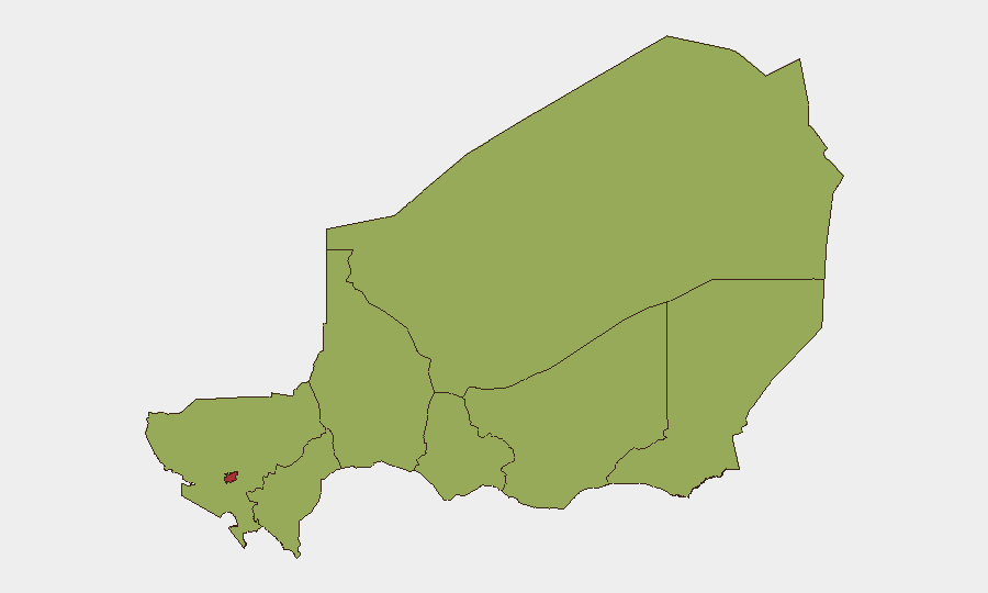
Niamey (risk 77.9) is now the dominant risk driver following the airport attack, reflecting both the scale of the June 18 incident and the demonstrated ability of jihadist networks to strike at the capital's most critical infrastructure. Agadez Region (53.8) remains the second-highest-risk area, consistent with its role as a logistics and transit hub for militant groups operating across the Sahel. The remaining seven regions cluster at 47.9–48, indicating sustained but lower-level jihadist activity and instability across the rest of the country, with particular concern in Diffa, Tillabéri, and Tahoua regions where border porosity and ungoverned spaces enable militant operations.
How GeoBit Would Assist
Security teams should deploy AOI Monitoring & Early Warning on Niamey's critical infrastructure (airport, military bases, government compounds) to detect unusual force movements or attack indicators. Network & Actor Analysis and OSINT fusion (Twitter/Telegram, radio SIGINT) would track JNIM communications, recruitment, and operational planning across the Sahel. Battle mapping, force-structure tracking, and alternative routing analysis enable real-time situational awareness for duty-of-care teams and asset protection during evolving counter-terrorism operations.
7-Day Outlook
Expect sustained counter-terrorism sweeps and heightened security postures around Niamey and other major urban centers through late June. JNIM or affiliated groups may attempt secondary attacks or claim additional operations to reinforce narrative momentum; airport and military operations will likely remain disrupted intermittently as security forces prioritize vulnerability reduction. Regional jihadist networks will monitor Niger's response to calibrate further Sahel-wide campaign activity.
Highest-Risk Areas — Ranked
| # | State / Region | Risk |
|---|---|---|
| 1 | Niamey | 77.9 |
| 2 | Agadez Region | 53.8 |
| 3 | Zinder Region | 47.9 |
| 4 | Diffa Region | 47.9 |
| 5 | Tillabéri Region | 47.9 |
| 6 | Tahoua Region | 47.9 |
| 7 | Dosso Region | 47.9 |
| 8 | Maradi Region | 47.9 |
Sources
Previous Daily Briefs
A new Niger brief is written every day — each with its own risk map and downloadable CSV. Here's the last week; use the calendar to go further back.
📅 Browse every day by calendar →
Highlighted days have a brief. Tap a day for that day's map & analysis, or “csv” for that day's dataset ($5).