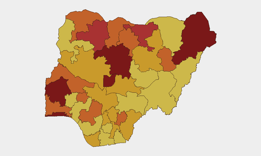
Situation Summary
Nigeria remains the world's second-highest composite threat environment, driven primarily by active insurgency, banditry, and kidnap-for-ransom operations across the North-West, North-Central, and parts of the South-West. Over the past 48 hours, security incidents have included a coordinated attack on a strategic government institution (NIPSS Kuru), continued high-casualty bandit operations in Katsina and Zamfara, and a documented surge in kidnappings and violent crime across North-Central states. The threat trajectory is deteriorating, with operational tempo increasing in traditionally high-risk zones and, critically, incidents now reaching institutions previously considered secure.
Key Developments
- NIPSS Kuru, Plateau State (18–19 June, night-early morning): Gunmen penetrated the perimeter of the National Institute for Policy and Strategic Studies, killing three security operatives (soldiers and one police officer) in a coordinated attack on security posts. NIPSS management confirmed the breach on 19 June, launched a formal investigation, and stated staff and participants remained safe; the incident underscores vulnerability of strategic civilian-government institutions to armed assault.
- Katsina State security measures (19 June): Governor Dikko Radda announced state-wide restrictions on fuel jerrycan sales, purchase, transport, and storage as a direct counter-logistics measure against bandit and kidnapper operations, following the recent killing of Major General Rabe Abubakar in bandit captivity.
- Rescue of Major General Abubakar's wife (18–19 June): Troops under Operation Hadarin Daji recovered Mrs. Amina Rabiu Abubakar from bandit captivity in the Katsina–Zamfara corridor; senior officials visited her on 19 June, indicating continued anti-kidnap operations in the North-West.
- North-Central escalation (reported 19 June): Security monitors and Nigerian media documented a "fresh wave" of deadly attacks, kidnappings, and violent crime across North-Central states, characterizing a documented worsening trend over preceding days; banditry, homicide, and kidnap-for-ransom incidents remain frequent.
- Kaduna State displacement crisis (19 June): The Kaduna State government announced a ₦34-billion environmental remediation and relocation project for Rigasa and nearby communities in Igabi LGA due to severe gully erosion; immediate relocation orders constitute a significant infrastructure and humanitarian displacement risk with local stability implications.
Highest-Risk Areas
Kaduna State (risk 100) remains the single highest-risk jurisdiction, followed closely by Lagos State (94.6) and the Federal Capital Territory (83.8), with North-Western states (Zamfara, Jigawa, Sokoto) and North-Central zones (Borno, Kano, Ebonyi) forming a high-risk corridor. Kaduna's rank is driven by overlapping threats: active banditry and kidnap operations in rural and semi-urban zones, intercommunal violence, and now documented security breaches at strategic institutions. Lagos and FCT risks reflect criminal networks, organized crime, and potential spillover from North-West insurgency. The North-West corridor (Katsina, Zamfara, Jigawa) represents persistent kidnap-for-ransom and bandit logistics hubs despite ongoing military operations.
How GeoBit Would Assist
Security teams managing personnel or assets in Nigeria should employ Intel Sweep and multi-source OSINT fusion to monitor real-time event cascades across Kaduna, Lagos, FCT, and the North-West corridor. AOI Monitoring & Early Warning with persistent geo-tagged alerts on Kaduna, Katsina, and Zamfara would provide 24-hour institutional and personnel protection against emerging attack patterns. Conflict & Military battle mapping and force-structure tracking enables coordination with Operation Hadarin Daji's known operational areas and tactical intelligence, while Network & Actor Analysis on bandit and kidnap-for-ransom cell organization supports threat profiling and route-risk assessment.
7-Day Outlook
Insecurity is expected to remain elevated across Kaduna and the North-West through the week, with continued bandit logistics disruption in Katsina unlikely to produce immediate relief. NIPSS Kuru's breach signals potential for future attempts on other strategic sites; heightened security posture at government institutions and corporate facilities is warranted. Kidnap-for-ransom and bandit-driven displacement risks in Kaduna, Katsina, Zamfara, and North-Central states will persist absent significant military gains.
Highest-Risk Areas — Ranked
| # | State / Region | Risk |
|---|---|---|
| 1 | Kaduna State | 100 |
| 2 | Lagos State | 94.6 |
| 3 | Federal Capital Territory | 83.8 |
| 4 | Oyo State | 82.2 |
| 5 | Borno State | 80.9 |
| 6 | Zamfara State | 79.3 |
| 7 | Jigawa State | 76.5 |
| 8 | Ekiti State | 74.8 |
| 9 | Kano State | 74.1 |
| 10 | Sokoto State | 73.7 |
| 11 | Ebonyi State | 73.7 |
| 12 | Ogun State | 73.5 |
Sources
Previous Daily Briefs
A new Nigeria brief is written every day — each with its own risk map and downloadable CSV. Here's the last week; use the calendar to go further back.
📅 Browse every day by calendar →
Highlighted days have a brief. Tap a day for that day's map & analysis, or “csv” for that day's dataset ($5).