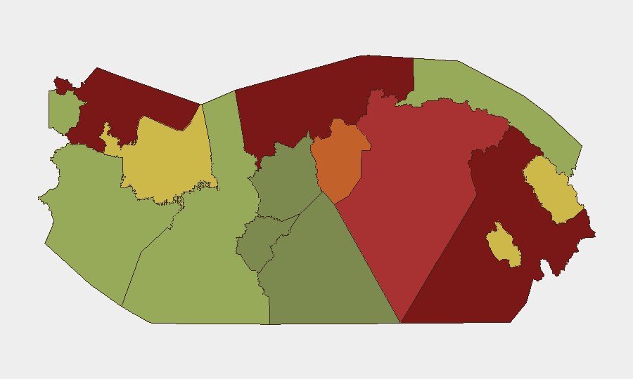
Situation Summary
Panama's composite threat score of 35 places it in the lower-to-moderate global risk band, but significant sub-national disparities exist. The past 48 hours show concentrated incidents in Colón province (armed homicide and suspect capture), urban road-safety crises in Panama City, and ongoing law-enforcement operations targeting firearm smuggling and escaped detainees. The security environment remains fragmented by geography: border and transit zones (Darién, Colón, Bocas del Toro) drive national risk scores, while urban violence and trafficking persist as steady-state threats in populated corridors.
Key Developments
- Colón province, Río Alejandro (El Cementito), night of July 21 – Armed attack killed a 52-year-old male and injured a 23-year-old female; incident part of an ongoing gun-violence spike in the province under investigation by Ministerio Público.
- Colón province, Alto de Los Lagos, July 21 – Police captured a suspect linked to a separate homicide in the same community, indicating multiple concurrent violent incidents across the province.
- Panama City, Avenida Domingo Díaz, July 24–25 – Fifth motorcyclist fatality on this major urban avenue in 72 hours; indicates acute short-term road-hazard concentration warranting route avoidance for commuting staff.
- Herrera province, Pesé district, July 24–25 – Police raid yielded one detained suspect and seizure of a 20-gauge shotgun, five cartridges, and communication radios; reflects ongoing small-arms interdiction operations.
- Operation "Anonymus" (national scope), developments July 24–25 – Federal authorities apprehended multiple individuals suspected of smuggling firearm components from the United States into Panama; cases referred to Ministerio Público. Investigation began July 2, 2026.
- Panamá Oeste, Arraiján district (Invasión de Villa Antigua), July 21–22 – Policía Nacional recaptured escaped homicide inmate Luis Pino Araúz hidden in a latrine; brings total recaptured escapees to 187, indicating ongoing prison-security management challenges.
Highest-Risk Areas
Darién (95), Colón (88), and Bocas del Toro (82) dominate the sub-national ranking, driven by transnational trafficking, porous borders, and limited state authority. Darién remains a critical node for narcotics and human-smuggling transit; Colón's Caribbean ports and proximity to the Canal Zone create layering of commercial, criminal, and security-force activities. The immediate metropolitan area—Panamá Province (78) and Panamá Oeste (75)—carries urban-violence and gang-related risk. Indigenous territories (Ngäbe-Buglé, Emberá-Wounaan, Guna Yala) score lower but warrant monitoring for isolated incidents and humanitarian access constraints. Western provinces (Chiriquí, 48) remain relatively lower-risk.
How GeoBit Would Assist
Security teams should deploy AOI Monitoring & Early Warning on high-risk provinces (Colón, Darién, urban Panama City corridors) to detect emerging violence clusters and route hazards in real time. OSINT fusion and multi-language search across local news, radio SIGINT, and social media will track operational tempo of firearm-smuggling networks and prison-escape incidents. GIS & Spatial Analysis paired with Routing & Network Analysis enables identification of safe commuting and supply-chain alternatives, particularly on corridors like Avenida Domingo Díaz experiencing acute fatality spikes.
7-Day Outlook
Near-term trajectory suggests persistent low-level armed violence in Colón and peri-urban Panama City, steady law-enforcement interdiction of trafficking operations, and continued prisoner-escape and recapture cycles. No indicators of imminent large-scale civil unrest or institutional instability; threat remains distributed and localized. Duty-of-care teams should maintain heightened situational awareness on personnel movement in Colón and maintain alternative routing for Panama City commuting.
Highest-Risk Areas — Ranked
| # | State / Region | Risk |
|---|---|---|
| 1 | Darién | 95 |
| 2 | Colón | 88 |
| 3 | Bocas del Toro | 82 |
| 4 | Panamá Province | 78 |
| 5 | Panamá Oeste | 75 |
| 6 | Ngäbe-Buglé | 68 |
| 7 | Emberá-Wounaan | 62 |
| 8 | Veraguas | 58 |
| 9 | Chiriquí | 48 |
| 10 | Naso Tjër Di | 45 |
| 11 | Guna Yala | 42 |
| 12 | Coclé | 35 |
Sources
Previous Daily Briefs
A new Panama brief is written every day — each with its own risk map and downloadable CSV. Here's the last week; use the calendar to go further back.
📅 Browse every day by calendar →
Highlighted days have a brief. Tap a day for that day's map & analysis, or “csv” for that day's dataset ($5).
Atlas — our AI intelligence desk — emails them this snapshot personally. Nothing else, no list.