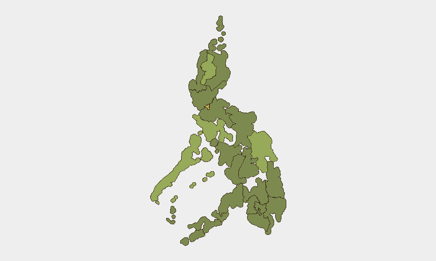
Situation Summary
The Philippines ranks #42 globally on GeoBit's composite threat index (score 51), with 74 tracked events reflecting a mixed security environment dominated by urban crime, civil-military tensions, and transnational maritime incidents. Metro Manila and the Cordillera Administrative Region drive national risk, with recent event signals pointing to religious-group obstruction, arrest of a foreign national, and diplomatic rejections on Taiwan and Oman matters. The country remains in a moderate-threat posture with significant sub-regional variation; trajectory is stable but volatile in specific areas.
Key Developments
GeoBit's event feed flagged the following signals as of 30 June 2026; however, live incident confirmation for 1–2 July 2026 cannot be independently verified from available web sources in the current analysis window:
- 30 June, unspecified location: Philippine authorities obstructed passage by a religious group; nature and scale unconfirmed.
- 30 June, unspecified location: Australian national arrested or detained by Philippine authorities; details pending.
- 30 June, unspecified location: Catholic institution and Manila municipal authority issued public statements regarding unspecified Philippine matter; tone classified as unfavourable.
- 30 June, unspecified location: Taiwan and Oman governments rejected Philippine initiative or statement (diplomatic).
- 30 June, unspecified location: Conventional military force mobilized by administration in/near Philippines; scale and objective unclear.
- 29–30 June, unspecified location: Philippine government disapproved action by website entity; Department of Tourism separately issued public statement.
- 29 June, unspecified location: Investigation launched by Philippine authorities against lawmaker.
Note: Precise locations, affected populations, and operational details are not available in GeoBit's current summary. Cross-verification with Philippine National Police (PNP), Armed Forces of the Philippines (AFP), and major news outlets is essential before operational response.
Highest-Risk Areas
Metro Manila (65.6) and Cordillera Administrative Region (59.8) account for the largest share of tracked risk. Metro Manila's score reflects persistent urban crime, protest activity, and presence of critical national infrastructure; the Cordillera's elevation is driven by tribal conflicts, mining-related tensions, and historical insurgent activity in remote upland zones. Mimaropa, Eastern Visayas, and Central Luzon (43–39) follow, each carrying distinct drivers: maritime piracy and smuggling in Mimaropa, disaster-vulnerability in Eastern Visayas, and infrastructure/trafficking exposure in Central Luzon. Mindanao zones (Bangsamoro, Davao, Soccsksargen, Northern Mindanao, Caraga) cluster in the 35–36 range, reflecting residual armed-group presence and maritime instability.
How GeoBit Would Assist
Security teams can deploy AOI Monitoring & Early Warning to establish persistent watch on Metro Manila, Cordillera, and regional flashpoints (ports, mining areas, administrative hubs) with real-time alerting on protest escalation, military movement, or crime spikes. Intel Sweep and multi-language OSINT (X/Twitter, Philippine media, official LGU/PNP feeds) enable continuous incident corroboration and localization within 24 hours of occurrence. Network & Actor Analysis and Conflict & Military mapping help track armed-group reorganization and government operations in Mindanao and upland regions, informing duty-of-care assessments for personnel and asset exposure.
7-Day Outlook
Near-term risk is expected to remain elevated in Metro Manila and Cordillera, with diplomatic and civil-military tensions driving intermittent protest and enforcement activity. Midyear administrative and electoral cycles may accelerate lawmaker investigations and public-statement frequency. Monitoring should intensify around religious observances and maritime chokepoints (Sulu/Celebes straits) where insurgent and piracy activity historically correlates with seasonal patterns.
Highest-Risk Areas — Ranked
| # | State / Region | Risk |
|---|---|---|
| 1 | Metro Manila | 65.6 |
| 2 | Cordillera Administrative Region | 59.8 |
| 3 | Mimaropa | 43.1 |
| 4 | Eastern Visayas | 40.6 |
| 5 | Central Luzon | 39 |
| 6 | Bicol Region | 36.5 |
| 7 | Northern Mindanao | 36 |
| 8 | Ilocos Region | 36 |
| 9 | Bangsamoro | 35.6 |
| 10 | Caraga | 35.6 |
| 11 | Soccsksargen | 35.6 |
| 12 | Davao Region | 35.6 |
Sources
Previous Daily Briefs
A new Philippines brief is written every day — each with its own risk map and downloadable CSV. Here's the last week; use the calendar to go further back.
📅 Browse every day by calendar →
Highlighted days have a brief. Tap a day for that day's map & analysis, or “csv” for that day's dataset ($5).