Situation Summary
Samoa remains a low-threat environment with no acute security incidents recorded in the past 24–48 hours. The composite threat score remains at 3 with zero tracked events, and current Australian government travel advice recommends exercising normal safety precautions. The primary non-security risk continues to be an ongoing dengue outbreak straining healthcare capacity; a magnitude 5.0 earthquake occurred 141 km south-southwest of Gataivai, but no casualties or infrastructure damage has been reported. Overall security posture is stable with no trajectory toward escalation.
Key Developments
- Nationwide – 22 Jul 2026: No new security incidents, civil unrest, infrastructure disruptions, or acute travel risks recorded in the past 24–48 hours across Samoa.
- Nationwide – seismic activity, recent: A magnitude 5.0 earthquake struck approximately 141 km south-southwest of Gataivai; no immediate damage assessments or emergency responses reported as of latest available data.
- Nationwide – ongoing health risk: Dengue outbreak continues with healthcare services under elevated pressure; this is a persistent travel and occupational-health risk rather than a new discrete incident, but relevant for duty-of-care planning.
- Nationwide – travel advisory status, 22 Jul 2026: Australian Smartraveller advisory remains current and unchanged, recommending normal safety precautions with no alerts for new security or infrastructure incidents.
Highest-Risk Areas
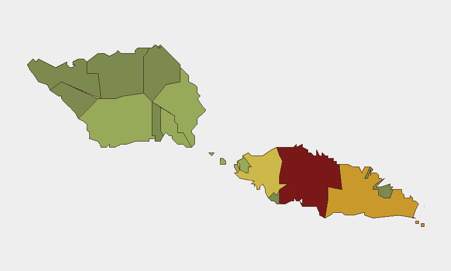
Tuamasaga (risk score 85) and Ātua (risk score 71) represent the two highest-risk districts, likely reflecting population density, economic activity, and associated urban-context vulnerabilities in and around Apia and coastal urban centers. Aʻana (62) and Aiga-i-le-Tai (55) follow, accounting for approximately 73% of the country's composite risk weighting. These rankings reflect chronic rather than acute drivers—urbanization, transport corridors, and social-service concentration—rather than current conflict, criminal spikes, or political instability. Remote and less-populated districts (Vaʻa-o-Fonoti, 23; Vaisigano, 28) carry substantially lower scores, consistent with Samoa's overall low-threat profile.
How GeoBit Would Assist
Security teams with personnel or assets in Samoa should use AOI Monitoring & Early Warning to establish persistent surveillance of Tuamasaga and Ātua, with alerting configured for civil unrest, infrastructure disruption, and health emergencies. Intel Sweep and multi-language OSINT capabilities enable continuous monitoring of local media, social platforms, and community channels to detect emerging tensions or incidents before they escalate. Environmental & Health data feeds should be maintained to track dengue case counts and healthcare capacity, informing occupational-health risk mitigation and evacuation protocols.
7-Day Outlook
No significant change in the security or threat trajectory is anticipated over the coming week. Dengue cases may continue to rise given current epidemiological momentum, but this poses occupational-health and healthcare-system risk rather than security risk. The seismic event does not indicate a heightened earthquake cluster; continued seismic monitoring is routine precaution rather than an urgent escalation signal. Samoa's governance and public-order environment remain stable, with no scheduled political events or high-risk dates on the horizon.
Prepared: 2026-07-22
Classification: Open Source
Next Update: 2026-07-23
Highest-Risk Areas — Ranked
| # | State / Region | Risk |
|---|---|---|
| 1 | Tuamasaga | 85 |
| 2 | Ātua | 71 |
| 3 | Aʻana | 62 |
| 4 | Aiga-i-le-Tai | 55 |
| 5 | Faʻasaleleaga | 48 |
| 6 | Palauli | 42 |
| 7 | Satupaʻitea | 38 |
| 8 | Gagaʻemauga | 35 |
| 9 | Gagaʻifomauga | 32 |
| 10 | Vaisigano | 28 |
| 11 | Vaʻa-o-Fonoti | 23 |
Previous Daily Briefs
A new Samoa brief is written every day — each with its own risk map and downloadable CSV. Here's the last week; use the calendar to go further back.
📅 Browse every day by calendar →
Highlighted days have a brief. Tap a day for that day's map & analysis, or “csv” for that day's dataset ($5).
Atlas — our AI intelligence desk — emails them this snapshot personally. Nothing else, no list.