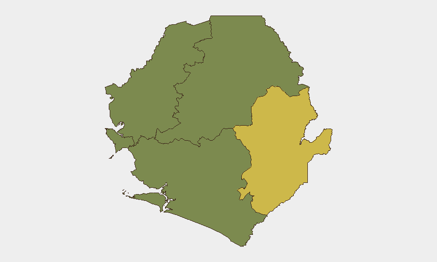
Situation Summary
Sierra Leone remains a stable but chronically high-risk environment with an elevated baseline of petty crime, opportunistic theft, and sporadic civil unrest. No significant new security incidents, civil unrest, or infrastructure disruptions have been corroborated in the last 24–48 hours; the country's composite threat ranking (#121 globally, score 8) reflects persistent structural vulnerabilities rather than acute escalation. A diplomatic signal—reduction in relations between Freetown and Conakry—marks the only event flagged in the immediate window, though its operational security implications for corporate assets remain limited. The security picture is stable but not improving.
Key Developments
- Freetown, 2026-07-01 · Diplomatic: Sierra Leone has signaled a reduction in diplomatic relations with Guinea (Conakry). The underlying drivers and operational impact on border transit, trade, or security access remain unclear from open sources; no immediate asset or personnel disruption has been reported.
- National, 2026-06-29 to 2026-06-30 · Crime/Policing: Routine crime and policing activity continues across major urban centers, with no acute incidents (riot, organized violence, or infrastructure failure) documented in the 24–48h window. Petty theft and opportunistic crime remain endemic, particularly in busy commercial areas of Freetown.
- Sahn Malen, Pujehun District, late June 2026 · Law Enforcement: Police have expanded custody of suspects (15 now in custody) linked to earlier unrest in the district. The investigative phase is active, but no new outbreak or violence has been reported; underlying incidents predate the last 48 hours.
- Border Areas (Guinea/Liberia), ongoing · Transnational Risk: No new cross-border raids, land-border closures, or transnational criminal incidents have been verified in the last 24–48 hours. Baseline risk of sudden border disruptions remains elevated and persistent.
- Freetown and Urban Centers, ongoing · Structural Risk: Government and advisory sources continue to flag water-access tensions and structural grievances as drivers of demonstration risk. No large-scale protest or riot has been documented in the immediate reporting window.
Highest-Risk Areas
Eastern Province drives national risk (composite score 68), reflecting endemic crime, weak governance, and transnational criminal activity along the Guinea and Liberia borders. Western Area (score 35), centered on Freetown, concentrates petty crime, theft, and demonstration risk in high-density commercial and residential zones, particularly after dark. Northern, North West, and Southern provinces register minimal tracked risk and remain relatively stable; however, absence of monitoring data does not guarantee absence of risk. For corporate operations, focus mitigation on Eastern Province border crossings and Western Area urban security (transport, accommodation, foot traffic).
How GeoBit Would Assist
Teams with personnel or assets in Sierra Leone should deploy AOI Monitoring & Early Warning on Eastern Province border crossings and key Freetown districts (Lumley, Eastern Freetown) to detect rapid changes in crime/unrest before they affect operations. Intel Sweep (global event feeds, X/Twitter & Telegram OSINT, multi-language search) provides 24-hour corroboration of incidents missed by mainstream media, reducing false alarms while catching emerging protests or criminal activity. Routing & Network Analysis supports alternative journey planning for staff and supply chains to avoid high-risk areas or sudden border closures, especially if the Conakry diplomatic tension extends to trade or transit restrictions.
7-Day Outlook
No significant escalation is anticipated in the next 7 days absent further diplomatic deterioration or secondary effects from the Guinea relations signal. Baseline crime and sporadic unrest will likely persist in urban and border areas. Security teams should monitor the diplomatic channel for any formal border restrictions or trade suspensions that could cascade into asset access or supply-chain disruption.
Highest-Risk Areas — Ranked
| # | State / Region | Risk |
|---|---|---|
| 1 | Eastern Province | 68 |
| 2 | Western Area | 35 |
| 3 | North West Province, Sierra Leone | 0 |
| 4 | Northern Province, Sierra Leone | 0 |
| 5 | Southern Province, Sierra Leone | 0 |
Sources
Previous Daily Briefs
A new Sierra Leone brief is written every day — each with its own risk map and downloadable CSV. Here's the last week; use the calendar to go further back.
📅 Browse every day by calendar →
Highlighted days have a brief. Tap a day for that day's map & analysis, or “csv” for that day's dataset ($5).