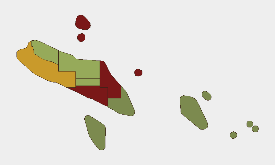
Situation Summary
Solomon Islands remains in a stable security posture as of 26 July 2026, with no verified acute incidents—protests, violence, infrastructure disruption, or civil unrest—documented in the past 24–48 hours. Baseline urban crime and historical communal tensions persist at routine levels, particularly in the capital and Guadalcanal Province. The country's overall composite threat score remains low (12 globally), and official travel advisories do not flag new, location-specific security events in the reporting window. Political and diplomatic activity continues at normal operational tempo.
Key Developments
- No acute security or civil-unrest incidents reported country-wide, 24–25 July 2026. Cross-checked open-source feeds, local media, and risk-monitoring tools confirm absence of protests, riots, armed clashes, mass-casualty crime, or port/airport disruption in Honiara, Guadalcanal, or provincial capitals during this window.
- Honiara and transport infrastructure remain operationally normal, 24–25 July 2026. No new airport closures, seaport disruptions, extraordinary security cordons, or evacuation orders have been initiated; routine VIP/diplomatic activity continues without incident.
- National political environment stable following recent external engagements, 24–25 July 2026. Diplomatic meetings held in Washington (21–22 July) regarding US Coast Guard cooperation and Peace Corps operations have not generated domestic protests or instability in Solomon Islands in the subsequent 48 hours.
- Local governance and infrastructure reporting routine, 24–25 July 2026. Solomon Islands media focus on vessel handovers and sea-transport projects with no mention of fresh violence, organized crime escalation, or civil disorder.
- Magnitude 4.7 seismic event recorded, 150 km SSE of Lata (Temotu Province, recent date). No tsunami warnings, casualties, or infrastructure damage have been reported; routine seismic activity in this region is documented but does not currently elevate regional risk assessment.
Highest-Risk Areas
Honiara (risk score 92) and Guadalcanal Province (88) dominate the sub-national ranking, driven by concentrated urban population, historical communal tensions, and baseline street crime. Malaita Province (85) follows, reflecting persistent inter-provincial friction and gang-related activity. Western Province (72) ranks fourth, reflecting maritime crime and smuggling corridors typical of Solomon Islands' remoter zones. These four provinces account for the majority of tracked events; the remaining six provinces (Choiseul through Temotu) exhibit materially lower risk scores, with Rennell/Bellona and Temotu in the lowest brackets, suggesting security capacity and stability increase markedly outside the capital and central zones.
How GeoBit Would Assist
Security teams with personnel or assets in Solomon Islands should employ AOI Monitoring & Early Warning to maintain persistent watch on Honiara and Guadalcanal for emergence of protests, gatherings, or unrest; Intel Sweep and multi-language OSINT (including X/Twitter, Telegram, and local media feeds) to detect early signals of political instability or communal tension before escalation; and Network & Actor Analysis to map gang, criminal, and militia networks in high-risk provinces and assess their operational tempo. GIS & Spatial Analysis can support alternative routing and secure-movement planning for staff transiting between Honiara and provincial operations.
7-Day Outlook
No credible indicators suggest imminent security deterioration in Solomon Islands over the next seven days. Routine political and economic activity is expected to continue; however, the historical volatility of communal tensions and gang activity in Honiara and Guadalcanal Province warrants sustained monitoring. Any escalation would likely manifest first in social media signals and street-level gathering activity detectable via OSINT, providing 24–48-hour advance warning for duty-of-care response.
Highest-Risk Areas — Ranked
| # | State / Region | Risk |
|---|---|---|
| 1 | Honiara | 92 |
| 2 | Guadalcanal | 88 |
| 3 | Malaita | 85 |
| 4 | Western | 72 |
| 5 | Choiseul | 58 |
| 6 | Isabel | 52 |
| 7 | Central Province | 48 |
| 8 | Makira-Ulawa | 38 |
| 9 | Rennell and Bellona | 22 |
| 10 | Temotu | 18 |
Sources
Previous Daily Briefs
A new Solomon Islands brief is written every day — each with its own risk map and downloadable CSV. Here's the last week; use the calendar to go further back.
📅 Browse every day by calendar →
Highlighted days have a brief. Tap a day for that day's map & analysis, or “csv” for that day's dataset ($5).
Atlas — our AI intelligence desk — emails them this snapshot personally. Nothing else, no list.