Situation Summary
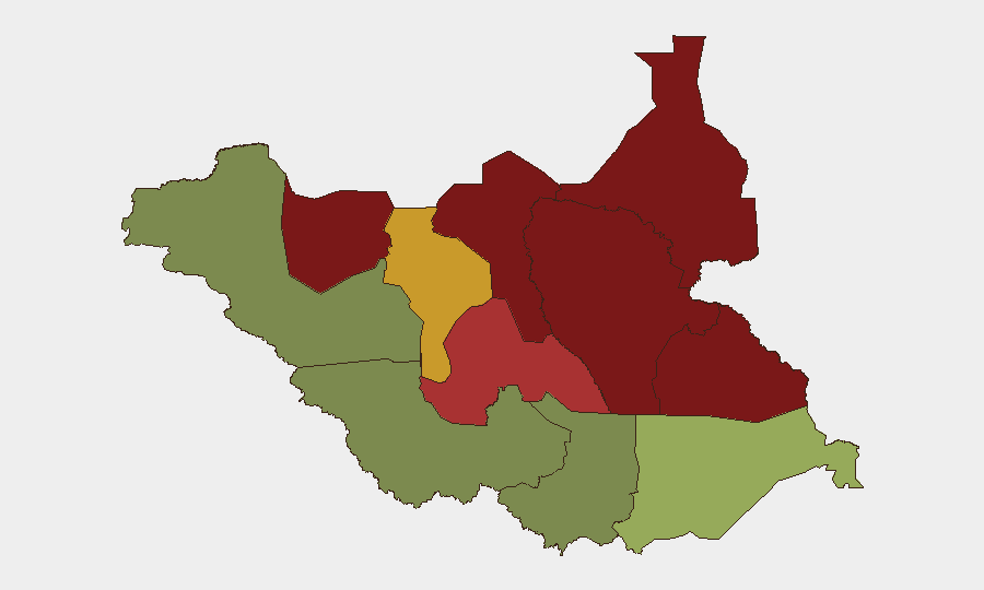
South Sudan remains in a state of fragile conflict equilibrium, with composite national threat score at 64 and zero discrete tracked events in the current observation window. However, confirmed reports from 7 July 2026 indicate renewed fighting and elevated casualty throughput, signaling a potential shift toward higher operational intensity. The geographic concentration of risk in northern and eastern states (Unity, Jonglei, Upper Nile) reflects ongoing competition for resources and territory among state and opposition forces. Trajectory remains uncertain but tilted toward escalation absent negotiated settlement or international intervention.
Key Developments
- Jonglei State, county-level (exact location undisclosed) — 7 July 2026 — Government sources confirmed the killing of a county commissioner; opposition forces attributed responsibility by state authorities. This represents a direct targeting of administrative officials and signals renewed violence in a persistently high-threat zone.
- South Sudan, nationwide health infrastructure — 7 July 2026 — The International Committee of the Red Cross reported a 50%+ increase in evacuations of wounded patients in H1 2026 compared to prior periods, indicating renewed combat operations and strain on trauma capacity across operational facilities.
- No other discrete incidents verified in the 24–48 hour window. Web research did not yield additional confirmed South Sudan-specific events with reliable sourcing; earlier-dated or non-specific material has not been included to avoid misrepresenting historical events as current.
Highest-Risk Areas
Unity State (risk 95) and Jonglei State (risk 93) anchor the threat landscape, followed by Upper Nile (88) and Greater Pibor Administrative Area (87). These four zones account for the majority of recorded conflict activity, resource competition, and presence of armed actors. The risk gradient drops sharply in Equatoria states (Eastern 52, Western 38, Central 35), where security conditions, while variable, remain significantly more stable than the north and east. Organizations with personnel or assets in Unity, Jonglei, and Upper Nile face materially higher exposure to armed confrontation, displacement, and supply-chain disruption; Equatoria-based operations face lower but non-zero risk from criminal activity and isolated communal violence.
How GeoBit Would Assist
Security and risk teams should deploy AOI Monitoring & Early Warning on high-risk counties in Jonglei, Unity, and Upper Nile, with persistent satellite and OSINT watch to detect force movements, camp establishment, or administrative disruption before downstream impact on operations. Conflict & Military force-structure tracking and Network & Actor Analysis would identify which opposition and state units are active in target areas and their command relationships, enabling scenario planning. Routing & Network Analysis supports real-time alternative-route planning for personnel or supply movement if primary corridors become unsafe; combined with Intel Sweep and multi-language OSINT, this enables duty-of-care teams to make informed evacuation or sheltering decisions ahead of escalation.
7-Day Outlook
The confirmed uptick in casualties and administrative targeting on 7 July suggests renewed operational tempo rather than isolated incident. Absent new ceasefire agreements or international diplomatic movement, violence intensity is likely to plateau or gradually increase over the next seven days. Organizations should assume persistent risk in northern/eastern states and prepare contingency protocols for rapid movement or communication loss.
Highest-Risk Areas — Ranked
| # | State / Region | Risk |
|---|---|---|
| 1 | Unity | 95 |
| 2 | Jonglei | 93 |
| 3 | Upper Nile | 88 |
| 4 | Greater Pibor Administrative Area | 87 |
| 5 | Northern Bahr el Ghazal | 82 |
| 6 | Lakes | 78 |
| 7 | Warrap | 72 |
| 8 | Ruweng Administrative Area | 68 |
| 9 | Eastern Equatoria | 52 |
| 10 | Western Equatoria | 38 |
| 11 | Central Equatoria | 35 |
| 12 | Western Bahr el Ghazal State | 28 |
Sources
Previous Daily Briefs
A new South Sudan brief is written every day — each with its own risk map and downloadable CSV. Here's the last week; use the calendar to go further back.
📅 Browse every day by calendar →
Highlighted days have a brief. Tap a day for that day's map & analysis, or “csv” for that day's dataset ($5).
Atlas — our AI intelligence desk — emails them this snapshot personally. Nothing else, no list.