Situation Summary
Sudan remains in acute civil war between the Sudanese Armed Forces (SAF) and Rapid Support Forces (RSF), with both state and non-state actors conducting widespread combat operations, drone strikes, and attacks on civilian infrastructure across 16 of 18 states. Drone warfare has intensified sharply, now accounting for approximately 80% of recorded civilian deaths (over 1,000 killed January–May 2026), with strikes targeting health facilities, markets, and water/energy infrastructure in Darfur, Kordofan, Blue Nile, and Khartoum. The conflict shows no signs of de-escalation; instead, geographic spread, documented sexual violence, and displacement continue to expand countrywide.
Key Developments
- June 16 (Geneva): UN High Commissioner for Human Rights Volker Türk reported that drone strikes in Sudan have killed over 1,000 civilians between January–May 2026, now representing ~80% of all recorded civilian deaths. Strikes are concentrated in South/Central Darfur, Blue Nile, White Nile, Khartoum, and Kordofan, targeting health facilities, markets, and critical infrastructure.
- June 16 (Geneva): UN Deputy High Commissioner documented 830 confirmed victims of sexual violence—including men and boys—across 16 of 18 states. Sexual violence and arbitrary detention by SAF, RSF, and allied groups have intensified and spread beyond original front lines into South/Central Darfur, Blue Nile, White Nile, Khartoum, and Kordofan.
- Last week (El-Obeid, North Kordofan): RSF drone strike on a cemetery and gas station killed at least 15 civilians, per local health officials. El-Obeid confirmed as an active drone-strike zone with elevated risk to civilian populations.
- June 1–14 (multi-state operations): SAF announced offensive operations across Darfur, Kordofan, Blue Nile, and White Nile, claiming destruction of 141 RSF combat vehicles and "dozens" of fighters, plus strikes on RSF ammunition depots, warehouses, and fuel infrastructure in Nyala (South Darfur). Communiqué released June 15–16.
- Recent days (Darfur/Kordofan → Western Bahr el Ghazal, South Sudan): Families fleeing "fierce fighting" in Darfur and Kordofan are arriving in Nagero County, South Sudan, requiring emergency assistance. Cross-border displacement confirms ongoing active combat intensity in Darfur and Kordofan states.
- June 16 (nationwide): IOM data indicates 4.44 million people have returned across Sudan, with nearly 75% concentrated in Khartoum and Gezira states (attributed to SAF territorial control). Large-scale population movements back into recently contested urban areas elevate civilian exposure in those zones.
Highest-Risk Areas
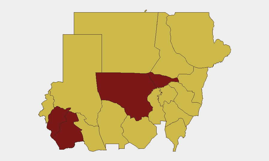
Central Darfur, North Kordofan, and Khartoum state drive the composite risk ranking due to active conventional warfare, drone strikes, and sexual violence spanning all three zones. Central Darfur ranks highest globally at risk score 100, followed by North Kordofan (94.2) and Khartoum (82.6), reflecting the concentration of recent SAF–RSF combat operations, documented drone strikes on civilian infrastructure, and cross-border displacement. Blue Nile, White Nile, and South Darfur (70–81.6) show similarly elevated risk from both drone and ground attacks. The 12-state secondary tier (risk 70) indicates conflict-driven violence and displacement are now nationwide.
How GeoBit Would Assist
Corporate security teams should deploy AOI Monitoring & Early Warning with persistent watch on Khartoum, Darfur states, Kordofan, and Blue Nile to capture drone-strike patterns, clashes, and displacement flows in near-real time. Battle Mapping and Conflict Intelligence (Intel Sweep, event feeds, OSINT fusion) enable tracking of SAF and RSF force positions, operations announcements, and casualty claims to assess ground control and safe-passage corridors. Routing & Network Analysis supports identification of alternative travel routes and crossing points away from active combat zones, critical for duty-of-care evacuation or supply-chain continuity in Khartoum and Gezira.
7-Day Outlook
Drone strikes, ground combat, and civilian targeting are expected to continue across Darfur, Kordofan, and Blue Nile without near-term military resolution. Large-scale returns to Khartoum and Gezira increase civilian density in areas still vulnerable to sporadic attacks and SAF–RSF clashes. Organizations with personnel or assets in Sudan should assume no improvement in security posture and maintain heightened vigilance and contingency readiness.
Highest-Risk Areas — Ranked
| # | State / Region | Risk |
|---|---|---|
| 1 | Central Darfur State | 100 |
| 2 | North Kordofan State | 94.2 |
| 3 | Al Khartum | 82.6 |
| 4 | South Darfur State | 81.6 |
| 5 | Blue Nile | 70 |
| 6 | River Nile State | 70 |
| 7 | Aj Jazira | 70 |
| 8 | Red Sea State | 70 |
| 9 | Al Qadarif State | 70 |
| 10 | Kassala State | 70 |
| 11 | Sennar State | 70 |
| 12 | West Kurdufan State | 70 |
Sources
Previous Daily Briefs
A new Sudan brief is written every day — each with its own risk map and downloadable CSV. Here's the last week; use the calendar to go further back.
📅 Browse every day by calendar →
Highlighted days have a brief. Tap a day for that day's map & analysis, or “csv” for that day's dataset ($5).