Situation Summary
Suriname remains a moderate-risk environment (global rank #89) with persistent security challenges concentrated in interior and border regions. Recent law-enforcement activity indicates active state response to transnational crime, though fragmented intelligence corroboration and limited verified incidents in the past 24–48 hours suggest the threat environment is neither acutely escalating nor fully transparent. Interior diamond and gold mining zones, as well as northern border districts, continue to exhibit structural vulnerability to smuggling, armed trafficking, and irregular activity. Overall trajectory is stable but operationally opaque.
Key Developments
- Sarakreek, interior Suriname — 15 July 2026: National police and military arrested 14 Chinese nationals following reports of armed individuals in uniform; firearms and ammunition seized. Suspects transferred to Paramaribo for criminal investigation, signaling active law-enforcement response to potential trafficking or private security violations in the mining interior.
- Paramaribo — 15 July 2026: Justice and Police Ministry confirmed ongoing investigation of the Sarakreek detainees, with cases remaining open and under judicial review.
- Multiple public statements (17–19 July): Presidential, ministerial, and environmental agency communications issued over the past 48 hours; specific content not yet corroborated by secondary sources. These align with signals of internal policy or administrative activity but lack operational security clarification.
- No additional verified acute incidents reported in the 24-hour window (18–19 July). Existing threat signals remain unresolved; investigation and event-characterization remain pending.
Highest-Risk Areas
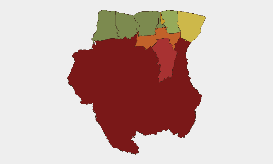
Sipaliwini district (risk score 92) dominates the threat landscape as the interior mining and border frontier, followed by Brokopondo (78), Para (74), and Paramaribo (71). These four regions account for structural vulnerabilities: Sipaliwini and Brokopondo host unregulated artisanal mining, informal labor migration, and drug-trafficking transshipment; Paramaribo concentrates urban crime, administrative chokepoints, and law-enforcement activity; Para sits on the Brazilian border and experiences spillover trafficking. Border districts Marowijne (68) and maritime-access Commewijne (42) present secondary smuggling and smuggling-crew risks. Western and coastal zones (Saramacca, Coronie, Nickerie) show markedly lower risk. Corporate and expatriate presence in Paramaribo and interior mines should prioritize situational awareness in interior supply chains and border crossings.
How GeoBit Would Assist
Duty-of-care teams should deploy AOI Monitoring & Early Warning on Sipaliwini, Brokopondo, and Paramaribo to track emerging incidents and trafficking signals in real time. OSINT fusion (X/Twitter, Telegram, local media, and radio SIGINT) combined with Network & Actor Analysis will identify informal armed groups, smuggling networks, and state responses, reducing intelligence gaps. GIS & Spatial Analysis and Routing & Network Analysis enable alternative-route planning for personnel and supply movement, avoiding high-risk mining zones and border chokepoints during operational windows.
7-Day Outlook
The Sarakreek investigation will likely remain the primary public-facing security event for 5–7 days; judicial outcomes and any follow-on arrests will signal state capacity and criminal network structure. No acute escalation is forecast, but the opaque corroboration of recent ministerial statements suggests continued low-level tensions around mining regulation, environmental policy, or cross-border control. Teams with personnel or assets in interior zones should maintain heightened situational awareness and contingency protocols.
Highest-Risk Areas — Ranked
| # | State / Region | Risk |
|---|---|---|
| 1 | Sipaliwini | 92 |
| 2 | Brokopondo | 78 |
| 3 | Para | 74 |
| 4 | Paramaribo | 71 |
| 5 | Marowijne | 68 |
| 6 | Commewijne | 42 |
| 7 | Wanica | 38 |
| 8 | Saramacca | 29 |
| 9 | Coronie | 12 |
| 10 | Nickerie | 8 |
Sources
Previous Daily Briefs
A new Suriname brief is written every day — each with its own risk map and downloadable CSV. Here's the last week; use the calendar to go further back.
📅 Browse every day by calendar →
Highlighted days have a brief. Tap a day for that day's map & analysis, or “csv” for that day's dataset ($5).
Atlas — our AI intelligence desk — emails them this snapshot personally. Nothing else, no list.