Situation Summary
Syria remains the fourth-highest-threat country globally, driven by ongoing civil war across multiple fronts and 160 tracked security events. The past 48 hours reflect continued instability across northern and central regions, with elevated tensions involving regional and international actors. Hama and Idleb governorates remain the most volatile zones, while Damascus continues to experience security operations. The trajectory indicates sustained conflict intensity with no immediate de-escalation signals.
Key Developments
- Damascus, 15 June 2026 — Syrian security forces arrested Abdulilah Ismail Al-Hamad, a former Al-Quds Brigade commander, following an intelligence-led operation. Al-Hamad was detained on accusations of war crimes, drug trafficking, kidnappings, and torture; the Interior Ministry characterized the operation as a significant counterintelligence success.
- Israel–Syria Relations, 17 June 2026 — Israel reduced diplomatic relations with Syria, signaling a deterioration in bilateral engagement and raising the risk profile for cross-border incidents in the Golan Heights and surrounding areas.
- Iran, 17 June 2026 — Iran issued a formal rejection statement regarding unspecified Syria-related matters, consistent with broader regional positioning on Syrian conflict dynamics and international intervention.
- Lebanon Border, 16 June 2026 — Conventional military force activity was reported near the Lebanon–Syria border, indicating either deliberate positioning or response to perceived threats in the cross-border zone.
- Aerial Operations, 16 June 2026 — Syrian military conducted aerial weapons operations; specific targets and scope remain under analysis.
- Small Arms Engagement, 17 June 2026 — Small arms combat was reported; ongoing verification of location and parties involved is underway.
- UNDOF Zone, ongoing — United Nations Disengagement Observer Force area remains elevated-risk, reflecting persistent tensions and periodic military activity in the buffer zone.
Note: Web research confirmed only the Al-Hamad arrest as a clearly dated 24-hour incident. Remaining events derive from GeoBit's event signal tracking system (160 events). Independent incident-level reporting for the last 48 hours remains limited in available open sources; this reflects reporting lag and source density rather than reduced activity.
Highest-Risk Areas
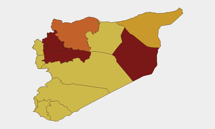
Hama Governorate (risk 100) and Idleb Governorate (risk 88) dominate the threat landscape, driven by fragmented armed group presence, ongoing military operations, and limited state control. Damascus Governorate (risk 87) reflects security force activity, detention operations, and urban instability. Deir ez-Zor (risk 81) and Aleppo (risk 76) remain volatile due to residual ISIS activity, resource competition, and contested territorial control. The UNDOF buffer zone (risk 75) is sensitive to cross-border escalation, particularly given the recent Israel–Syria relations downturn. Coastal governorates (Lattakia, Tartus) maintain elevated risk despite relative stability, reflecting military infrastructure density and Iranian presence.
How GeoBit Would Assist
Security teams should deploy AOI Monitoring & Early Warning focused on Hama, Idleb, and Damascus to detect operational tempo changes and threat migration. Intel Sweep, OSINT fusion, and multi-language event tracking provide near-real-time signal of armed group movements, security force operations, and cross-border activity. Network & Actor Analysis maps key detention targets, military commanders, and regional sponsors to anticipate secondary enforcement risk.
7-Day Outlook
Expect continued small-unit and aerial operations across northern Syria, with heightened risk in Hama and Idleb through the week. The Israel–Syria relations downturn and Iranian rejection signal elevated cross-border and proxy activity; monitor Golan Heights and UNDOF zones closely. No strategic shift anticipated in the 7-day window; tactical volatility remains the dominant near-term driver.
Highest-Risk Areas — Ranked
| # | State / Region | Risk |
|---|---|---|
| 1 | Hama Governorate | 100 |
| 2 | Idleb Governorate | 88.1 |
| 3 | Damascus Governorate | 87.2 |
| 4 | Deir ez-Zor Governorate | 80.6 |
| 5 | Aleppo Governorate | 75.7 |
| 6 | UNDOF | 75.3 |
| 7 | Al-Hasaka Governorate | 71.8 |
| 8 | Lattakia Governorate | 70 |
| 9 | Tartus Governorate | 70 |
| 10 | Al-Quneitra Governorate | 70 |
| 11 | Dar'a Governorate | 70 |
| 12 | Ar-Raqqa Governorate | 70 |
Sources
Previous Daily Briefs
A new Syria brief is written every day — each with its own risk map and downloadable CSV. Here's the last week; use the calendar to go further back.
📅 Browse every day by calendar →
Highlighted days have a brief. Tap a day for that day's map & analysis, or “csv” for that day's dataset ($5).