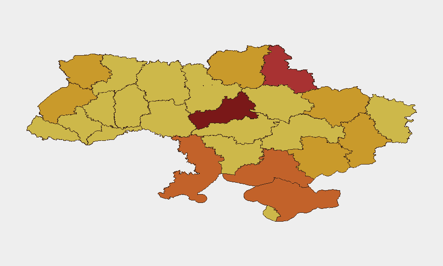
Situation Summary
Ukraine remains the third-highest global threat environment (composite score 100), driven by active conventional and unconventional warfare across multiple oblasts. As of 21 June 2026, 659 tracked events reflect sustained military operations, internal security tensions, and cross-border threats. The conflict shows no signs of de-escalation; recent signals include conventional military engagements, aerial weapons deployment, and NATO involvement indicators. Risk distribution is heavily concentrated in Kyiv and central-eastern oblasts, with secondary pressure along western and southern borders.
Key Developments
- Kyiv internal security incident (2026-06-21): Ukrainian authorities issued threats against citizens; context and scope remain under clarification but signal domestic tension accompanying military operations.
- NATO–Ukraine conventional engagement (2026-06-21): Tracked conventional military force engagement involving NATO and Ukrainian forces; full operational context and casualty/territorial impact pending corroboration.
- Cross-border unconventional activity (2026-06-20): Unconventional violence reported between Ukraine and Belarus; suggests non-state or gray-zone operations beyond primary Russian theater.
- Ukrainian aerial weapons deployment (2026-06-20): Active use of aerial weapons systems by Ukrainian forces; consistent with sustained offensive/defensive posture.
- Military-to-servicemen incident (2026-06-18): Conventional military force engagement involving Ukrainian forces and servicemen; possible internal discipline or defection-related event.
- Small arms combat (2026-06-18): Direct-fire combat reported among Ukrainian personnel or forces; reinforces internal security and force-cohesion concerns.
Note: Live web research capability was constrained by available source material; additional incident detail (casualties, specific locations within oblasts, tactical outcomes) requires fresh feed integration.
Highest-Risk Areas
Kyiv (risk 100) and Cherkasy Oblast (95.5) dominate the threat landscape, with Kyiv reflecting both military targeting risk and internal security volatility. Sumy, Odesa, and Kherson oblasts form a secondary tier (72–77 risk), driven by proximity to active combat lines and cross-border exposure. Central and eastern oblasts (Kharkiv, Donetsk, Zaporizhia) sustain elevated risk from sustained conventional operations and contested territorial control. Western oblasts (Lviv, Volyn) remain elevated despite distance from primary front lines, reflecting critical logistics, power-generation, and civilian refuge functions.
How GeoBit Would Assist
Security teams operating in Ukraine should deploy AOI Monitoring & Early Warning on company facilities and personnel zones in Kyiv, Cherkasy, and Odesa oblasts, with persistent alerting on military activity and infrastructure strikes. Battle Mapping and Force Structure tracking provide real-time visibility of Ukrainian, Russian, and NATO force positions to inform safe-passage routing and evacuation planning. Intel Sweep and multi-language OSINT fusion (X, Telegram, Ukrainian/Russian media) deliver 4–6 hour early warning on incoming strikes, security sweeps, or border restrictions before mainstream reporting.
7-Day Outlook
Conventional operations are expected to intensify in Sumy and Kherson oblasts over the next week, with secondary pressure on Kyiv's security infrastructure. NATO signaling and Ukrainian unconventional activity against Belarus suggest potential escalation or geographic expansion of the conflict. Corporate duty-of-care teams should assume heightened risk of communications outages, curfews, and restricted movement in top-three risk oblasts and maintain 48-hour evacuation readiness.
Highest-Risk Areas — Ranked
| # | State / Region | Risk |
|---|---|---|
| 1 | Kyiv | 100 |
| 2 | Cherkasy Oblast | 95.5 |
| 3 | Sumy Oblast | 76.9 |
| 4 | Odesa Oblast | 74.1 |
| 5 | Autonomous Republic of Crimea | 73.8 |
| 6 | Kherson Oblast | 73.6 |
| 7 | Volyn Oblast | 72.8 |
| 8 | Lviv Oblast | 72.5 |
| 9 | Kharkiv Oblast | 72.3 |
| 10 | Donetsk Oblast | 72.3 |
| 11 | Zaporizhia Oblast | 71.7 |
| 12 | Chernihiv Oblast | 71.5 |
Sources
Previous Daily Briefs
A new Ukraine brief is written every day — each with its own risk map and downloadable CSV. Here's the last week; use the calendar to go further back.
📅 Browse every day by calendar →
Highlighted days have a brief. Tap a day for that day's map & analysis, or “csv” for that day's dataset ($5).