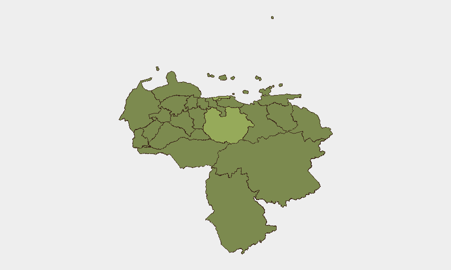
Situation Summary
Venezuela is experiencing a nationwide crisis following two major earthquakes on 24 June and continuing aftershocks through 27–28 June, prompting declaration of a state of emergency. Infrastructure damage is widespread, casualties are reported in the tens of thousands, and tens of thousands remain missing. International search-and-rescue operations are underway in Caracas and affected regions, while security and essential services remain severely strained. The security environment has deteriorated significantly, with foreign travel advisories now advising against all travel to Venezuela.
Key Developments
- Nationwide – 27–28 June 2026: Venezuela declared a nationwide state of emergency following back-to-back major earthquakes and multiple aftershocks, with widespread infrastructure damage, disrupted transport (airport closures, flight suspensions), and confirmed high casualty figures.
- Caracas – 27–28 June 2026: International rescue teams, including U.S. Urban Search and Rescue units (California, Virginia) and specialized teams from Mexico, Chile, and Colombia, deployed in-country to conduct active search-and-rescue operations for survivors trapped under rubble.
- Caracas and western Venezuela – 27–28 June 2026: Emergency responders indicate the next 24–48 hours remain critical for survivor recovery, signaling ongoing intensive rescue efforts and elevated risk in affected urban areas where infrastructure collapse remains a secondary hazard.
- Multiple regions, including coastal areas – 27–28 June 2026: Humanitarian organizations (WFP, UN-linked responders) report large-scale displacement, severe building and infrastructure damage, and significant access constraints; operations prioritizing emergency food, medical support, and shelter in most-affected zones.
- Nationwide – 27–28 June 2026: Updated international travel advisories cite heightened security and safety risks, severe infrastructure damage, and disrupted essential services (water, power, medical care) across the country.
- Caracas – 27–28 June 2026: Security system strain is acute; police and emergency services are overwhelmed by displacement, missing-persons reports, and demands for immediate aid, creating secondary risks including potential civil unrest and reduced government capacity to maintain order.
Highest-Risk Areas
Guarico State ranks highest (57.6) followed by the Federal District—Caracas proper (49.7), reflecting the concentration of earthquake impact, population density, and rescue complexity in capital and central regions. Vargas State (40.6) and Anzoategui State (37.4) also show elevated risk, consistent with reports of coastal and western damage. The ranking reflects a shift from the pre-earthquake baseline: acute physical infrastructure collapse, humanitarian need, and constrained security apparatus now dominate threat drivers in these regions over typical criminal or political event patterns.
How GeoBit Would Assist
Security teams operating in Venezuela should leverage AOI Monitoring & Early Warning to track real-time changes in Caracas, Guarico, and Vargas (satellite & imagery analysis, persistent watch with alerting for aftershocks, displacement, or secondary infrastructure failures). Routing & Network Analysis can identify alternative supply-chain, personnel-movement, and evacuation pathways as primary routes remain damaged or blocked. Multi-language OSINT and event-feed fusion will provide corroborated signals on emergency declarations, health-system status, and security-force positioning before they reach corporate channels, enabling faster duty-of-care response and asset repositioning.
7-Day Outlook
The immediate 48–72 hour window remains critical for rescue operations; aftershock risk persists, and casualty counts may rise as damage assessment continues. Over 7 days, expect stabilization of emergency response in Caracas, but widespread infrastructure repairs and service restoration will remain incomplete, sustaining elevated operational risk and mobility constraints. Secondary crises (disease, civil unrest, supply shortages) are likely to emerge as acute rescue phase transitions to recovery; security posture should remain elevated across all high-risk states.
Highest-Risk Areas — Ranked
| # | State / Region | Risk |
|---|---|---|
| 1 | Guarico State | 57.6 |
| 2 | Federal District | 49.7 |
| 3 | Vargas State | 40.6 |
| 4 | Anzoategui State | 37.4 |
| 5 | Carabobo State | 30.2 |
| 6 | Lara State | 28.4 |
| 7 | Tachira State | 28.2 |
| 8 | Barinas State | 27.9 |
| 9 | Miranda State | 27.9 |
| 10 | Zulia State | 27.7 |
| 11 | Aragua State | 27.7 |
| 12 | Monagas State | 27.7 |
Sources
Previous Daily Briefs
A new Venezuela brief is written every day — each with its own risk map and downloadable CSV. Here's the last week; use the calendar to go further back.
📅 Browse every day by calendar →
Highlighted days have a brief. Tap a day for that day's map & analysis, or “csv” for that day's dataset ($5).